México City in the time before humans – (México City and Me supplement one)
High – but not Rocky Mountain High
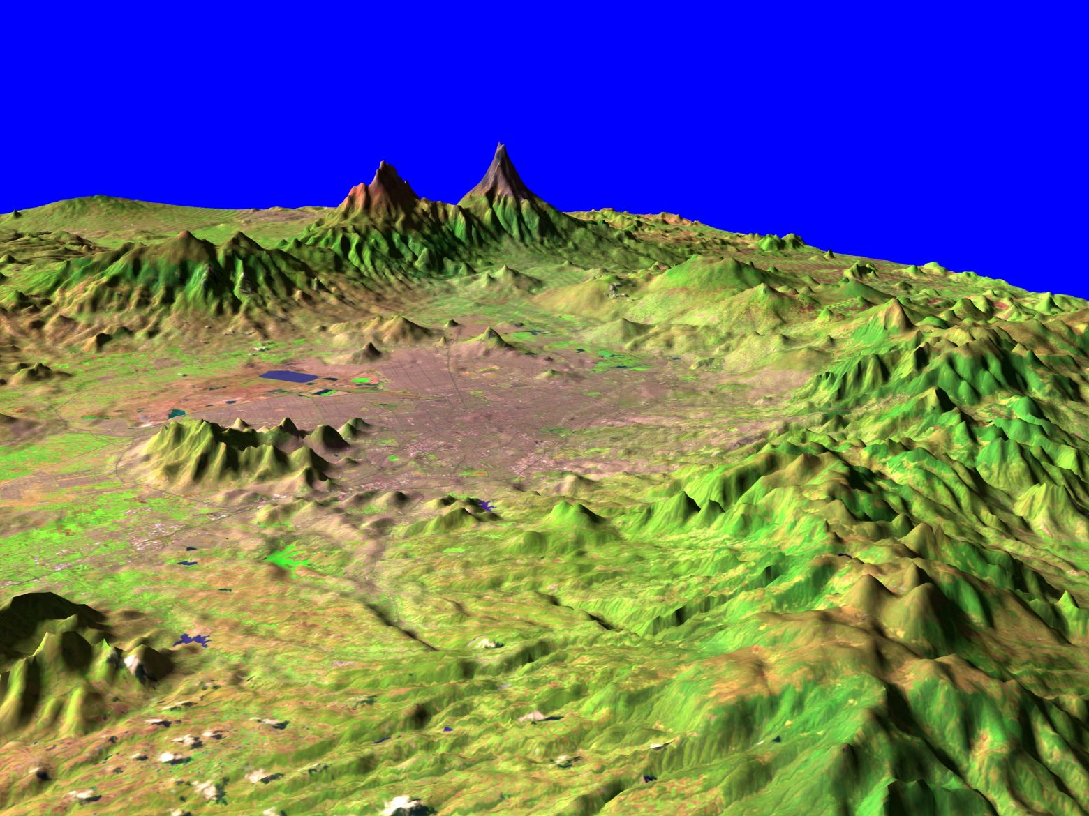
Sitting 2,240 meters above seal level México City is, by far, at the highest altitude of any city to host the Summer Games. Given that its elevation was among the concerns expressed by some people in the leadup to the Games it would be reasonable to assume that it sits somewhere in the midst of a mountain range and that this post would be primarily another cerebral tectonic collision. Reasonable but not entirely accurate.
Geologically, México City lies in the México Basin which is a volcano‑tectonic depression surrounded by the Sierra de las Cruces, Sierra Nevada, Sierra de Guadalupe and Sierra de Chichinautzin Ranges.

[From NASA/Goddard Space Flight Center Scientific Visualization Studio]
These andesitic-dacitic volcanic ranges are part of the Trans‑Mexican Volcanic Belt (TMVB). (Andesitic-dacitic describes volcanic rocks and magmas comprised of intermediate silica content that falls between andesite {lower silica} and dacite {higher silica, approaching rhyolite}). This discussion won’t exclude tectonics but will focus principally on volcanism.
The Ring of Fire – but not Johnny Cash’s Ring of Fire
We’ve encountered the Ring of Fire several times as we’ve journeyed through Olympic host cities along both sides of the Pacific Ocean. For those who don’t recall or haven’t read about this Pacific Ring of Fire
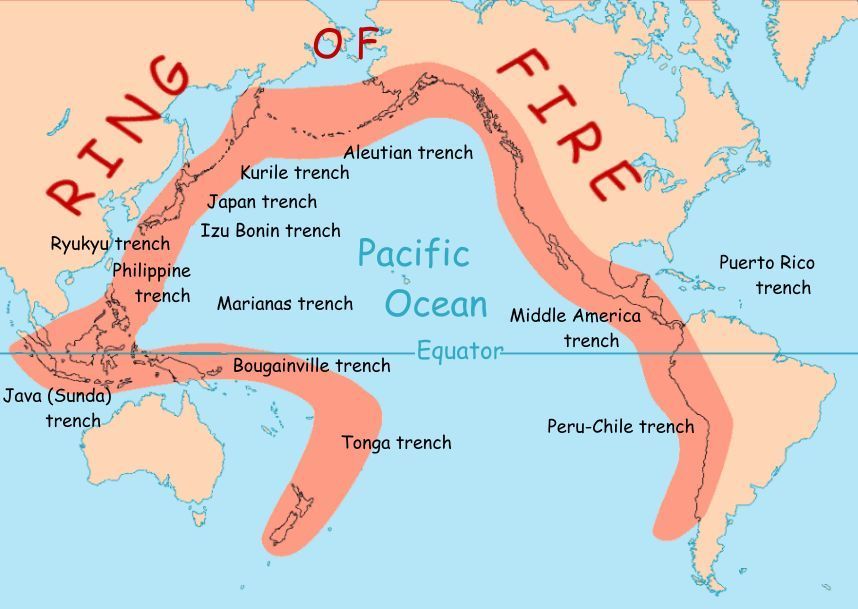
[From National Geographic and USGS.]
it’s essentially a belt encircling the Pacific Ocean where, according to the best geologic estimates, one can find evidence for 452 of the world’s 600 or so volcanoes known to have erupted in human history. As you can see from the map above, the Ring stretches over much of México including its capital city.
You might recall that when I wrote about Japan I called it geologically adolescent because the bulk of the land masses in the archipelago reached the surface about 500 million years ago (MYA) or only the most recent one-ninth of the planet’s history. If that analogy holds, México City and its surrounds are in their infancy.
Starting in the Miocene, around 23–20 million years ago, the Cocos and Rivera plates subducted beneath the North American plate generating substantial subduction related volcanism.
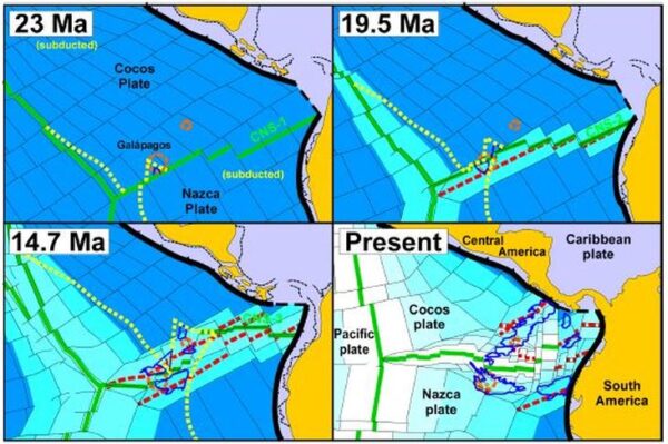
[From Americas: Tectonics – By Meschede and Barckhausen 2000]
This process created an east-west volcanic arc via flux melting, slab flattening, and later slab tears or windows, rather than compressional folding and thrusting.
(Flux melting is a process where the addition of volatile substances, such as water or carbon dioxide, lowers the melting point of hot solid rock in the Earth’s mantle or crust, triggering partial melting to form magma. Flux melting explains much of the explosive volcanism in circum-Pacific regions.
Slab flattening refers to a subduction zone process where the descending oceanic slab shifts from a steep dip to a near-horizontal orientation, suppressing typical arc volcanism.
Slab tears are gaps or ruptures in a subducting plate formed during tectonic processes. Stress localization in the downward headed slab, often triggered by subduction of mid-ocean ridges, slab breakoff, or lateral variations in plate convergence creates these gaps.
Slab windows emerge as the tear widens into a void, thereby allowing other mantle interactions such as being filled by upwelling asthenospheric mantle. This sometimes generates distinct effects like anomalous volcanism.)
Down in the valley – but not the valley so low
The subduction dance between the Cocos and Rivera plates began in the early Miocene (about 23 MYA) but another process began to take hold in the late Miocene beginning 11 MYA. About five million years into that period, continuing tectonic processes separated the Baja California Peninsula from mainland México and created the Gulf of California. Toward the end of this process, flat slab subduction prompted an inland migration of volcanism and the area was beset by a period of pulse vulcanism. (Pulse vulcanism is a rhythmic, cyclical activity within volcanoes, observed through seismic changes, ground deformation, and magma movement.) This late mafic pulse arose from slab tears and allowed the flow of hot ductile material from the asthenosphere (the weak flowing layer in the Earth’s upper mantle). Counterclockwise rotations and extensional tectonics segmented the belt into frontal (flux-dominated) and rear-arc zones with monogenetic fields. (These are small geographic areas with many small volcanoes, each formed by a single, short-lived eruptive event.)
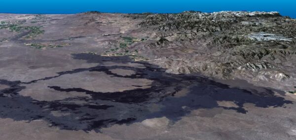
[From NPS – Craters of the Moon Monogenetic Field – Landsat Photo NASA Earth Observatory]
The Valley of México Basin originated as a tectonic depression amid the Trans-Mexican Volcanic Belt beginning in the Pliocene Era roughly three million years ago. In this eastern section of the TMVB, regional extension weakened the Earth’s crust, causing it to subside. Volcanic eruptions from nearby mountain chains that included peaks such as Popocatépetl and Iztaccíhuatl –
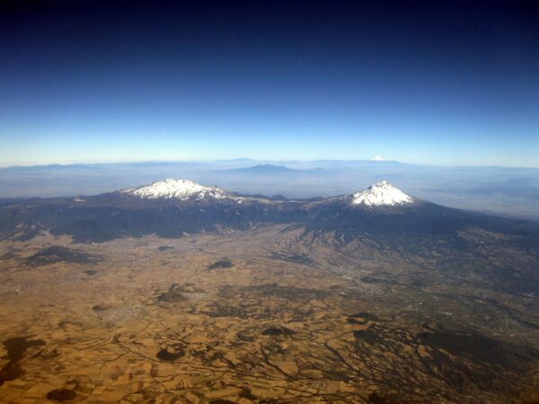
[From Wikipedia – By Haakon S. Krohn – Own work, CC BY-SA 3.0]
stratovolcanoes that formed within the last million years – reactivated faults channeling subduction-derived magmas. Fault systems like the Mixhuca and Tenochtitlan displaced Miocene rocks adding to its irregular floor shape. The erupting volcanoes produced lava flows, domes, pyroclastic deposits, destructive mud flows (lahars), and debris avalanches. These then form coarser ground on the basin margins and piedmont zones. Surrounding highlands formed natural barriers, trapping sediments and volcanic ash over time and the process provided the topographic bowl in which Lake Texcoco and related lakes developed. Pliocene-Quaternary basalts and calderas filled the basin and created the conditions for an endorheic lake.
(An endorheic lake is a lake with no natural outflow. Water collects and remains in the basin until it evaporates. Two lakes I’ve encountered in my travels are endorheic – Utah’s Great Salt Lake and Lake Titicaca – although the latter is often called semi-endorheic because it loses a small amount of its water through the outflow of the Desaguadero River into Lake Poopó. The Caspian Sea and Lake Chad are two other examples of endorheic lakes that readers might find familiar.)
During the Pleistocene, repeated glaciations in the closed basin deposited layers of fine-grained material such as silt, sand, and clay together with some organic matter collectively known as lacustrine sediments. These sediments act as natural archives of past climates, ecosystems, and geological events called paleosols.
México City and the great disappearing act of Lake Texcoco
During the Late Pleistocene and last glacial maximum (about 120,000 to 20,000 years BP), the basin held a much larger and deeper freshwater to slightly brackish lake that occupied most of the México Valley. Around 11,000 years ago the lake reached its largest extent – an estimated 5,670 km² with depths of more than 150m. It was fed largely by snowmelt and runoff from nearby glaciated mountains.
As the climate gradually warmed between 11,000 and 6,000 years ago, decreased snowfall and changing precipitation caused lake levels to fall. This fragmented the single large water body into several interconnected lakes, including Texcoco, Xaltocan, Zumpango, Chalco, and Xochimilco.
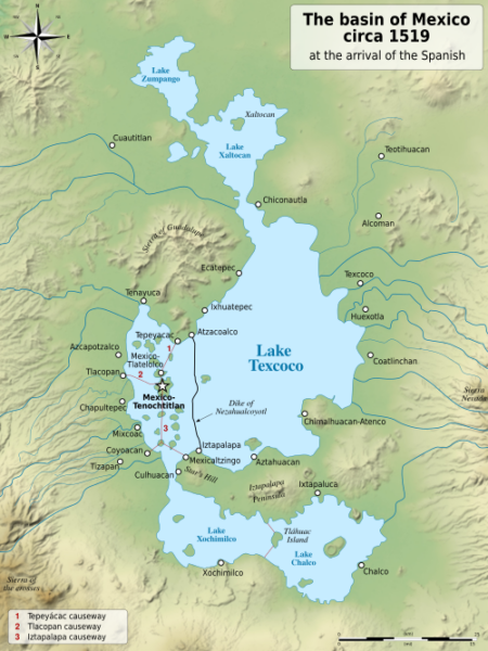
[From Wikimedia Commons (UTC) derivative work Sémhur, CC BY-SA 4.0.]
Geological and palaeoecological evidence indicates Texcoco experienced multiple cycles of desiccation and refilling over the last 30,000 years, becoming increasingly shallow, alkaline, and saline, with intermittent marsh conditions especially over the last 7,000 years. By the mid-to-late Holocene, Texcoco was the largest and lowest of the valley’s lakes. Despite inflow from higher, fresher lakes, the lake’s salinity increased because it was endorheic. Surviving remnants of shorelines from higher stands of the lake remain visible on slopes of nearby mountains such as Mount Tlaloc and provide a record of the long-term regression trend – a trend that humans would accelerate.
As noted above, a gradually warming climate over a 5,ooo year period contributed to falling lake levels. After establishing the island city of Tenochtitlán in the fourteenth century, Mexica construction projects such as chinampas, causeways, and dikes promoted sedimentation and altered hydrology in ways that accelerated drying in the saline Texcoco basin.
By the time the Spanish arrived in the early sixteenth century, the single lake had already fragmented into the five lake system seen in the map above. At an estimated 1,500 km² the entire system was slightly more than 25% of its original size.
Following the Spanish conquest in 1521, flood-control projects like the Nochistongo tunnel (starting in 1608) and prioritizing urban expansion over the natural lacustrine system irreversibly accelerated the lake’s dramatic decline.
México City itself began as a Mexica (Aztec) island city called Tenochtitlán. And we’ll take a deeper look at that aspect in a later post. But there’s considerable human history to explore before the Mexica established Tenochtitlán and that, too, is coming a bit later.
-

Here are the songs from the México City and México City Olympics posts
May 18, 2026 -

Notes on the XIX Olympiad – the quiet protest – (México City and Me addendum three)
May 18, 2026 -

Notes on the XIX Olympiad – Successes, failures, and a Flop – (México City and Me addendum two)
May 15, 2026 -

Notes on the XIX Olympiad – Understanding Carlos and Smith – (México City and Me addendum one)
May 13, 2026 -

Y no te puedo hallar
May 11, 2026