The Salmon Arches – Part 3
No Beating a Dead Horse.
As I left Arches to drive the short 26 miles to Dead Horse Point, (probably half that distance for a bird), in another demonstration of the importance of timing, there was no longer a backup at the park’s entrance. I still had the option of visiting Canyonlands because so close are the two parks that, the first 22 miles of the 26-mile trip from Arches is identical. To reach Dead Horse Point, you turn right to stay on Utah 313 for four miles. Eschew the right turn and continue onto Grand View Point Road (called on some maps Island in the Sky Road) for a similar distance and you enter Canyonlands.
And it was certainly a tempting option. Canyonlands is by far the largest of Utah’s “Mighty Five” National Parks. It’s more than twice the size of Zion, nearly five times larger than Arches, and dwarfs Bryce Canyon covering more than 10 times the acreage of its relatively tiny companion. (Of the 59 areas officially designated National Parks, only nine are smaller than Bryce Canyon while about 20 are larger than Canyonlands. Don’t confuse National Parks with National Monuments such as Organ Pipe or any of the 417 other units the NPS oversees.)
Canyonlands is divided into four major districts, two of which – the Island in the Sky and the Needles – are accessible by car. While I’m certain that enough daylight remained for me to make a quick pass through the closer of the two – Islands in the Sky – it seemed that such a visit would give short shrift to a place that the environmentalist Edward Abbey called “the most weird, wonderful, magical place on earth.”
Two other factors came into play as well. First, while it might be hard to believe, as I noted previously, I’d about reached what I’ll call my canyon saturation point for this trip. While there’s enough difference between them that the canyons hadn’t quite morphed into full on ooh-aah status, my reactions to their majestic scenery had grown perilously close to conferring that designation on them. Of greater importance was my long-standing mental date with the small nearby state park.
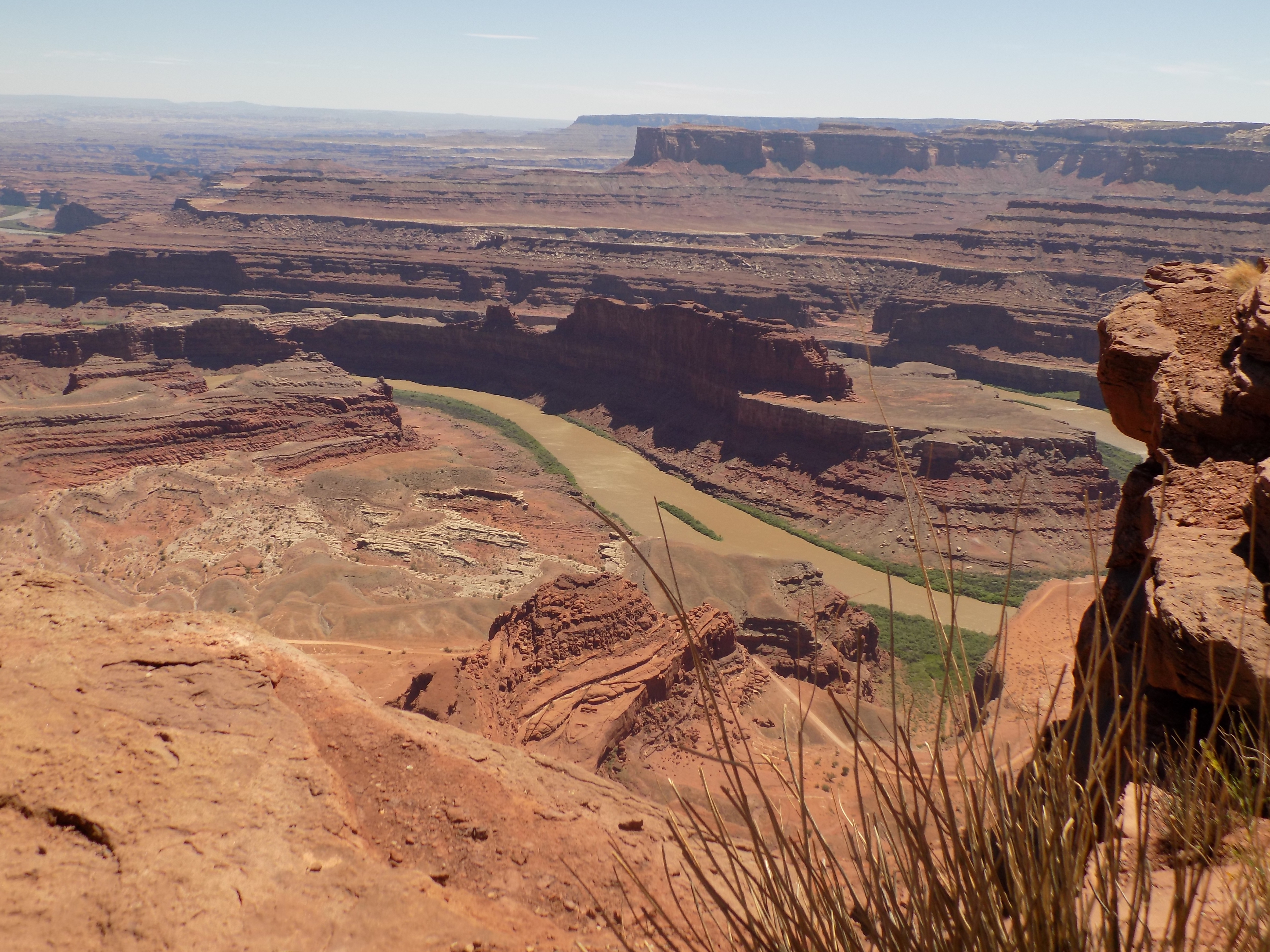
The 5,300-acre Dead Horse Point State Park sits atop a peninsula of land extending off the same section of the Colorado Plateau as the Island in the Sky district at Canyonlands but it’s at a higher elevation than the White Rim Trail of its giant neighbor.
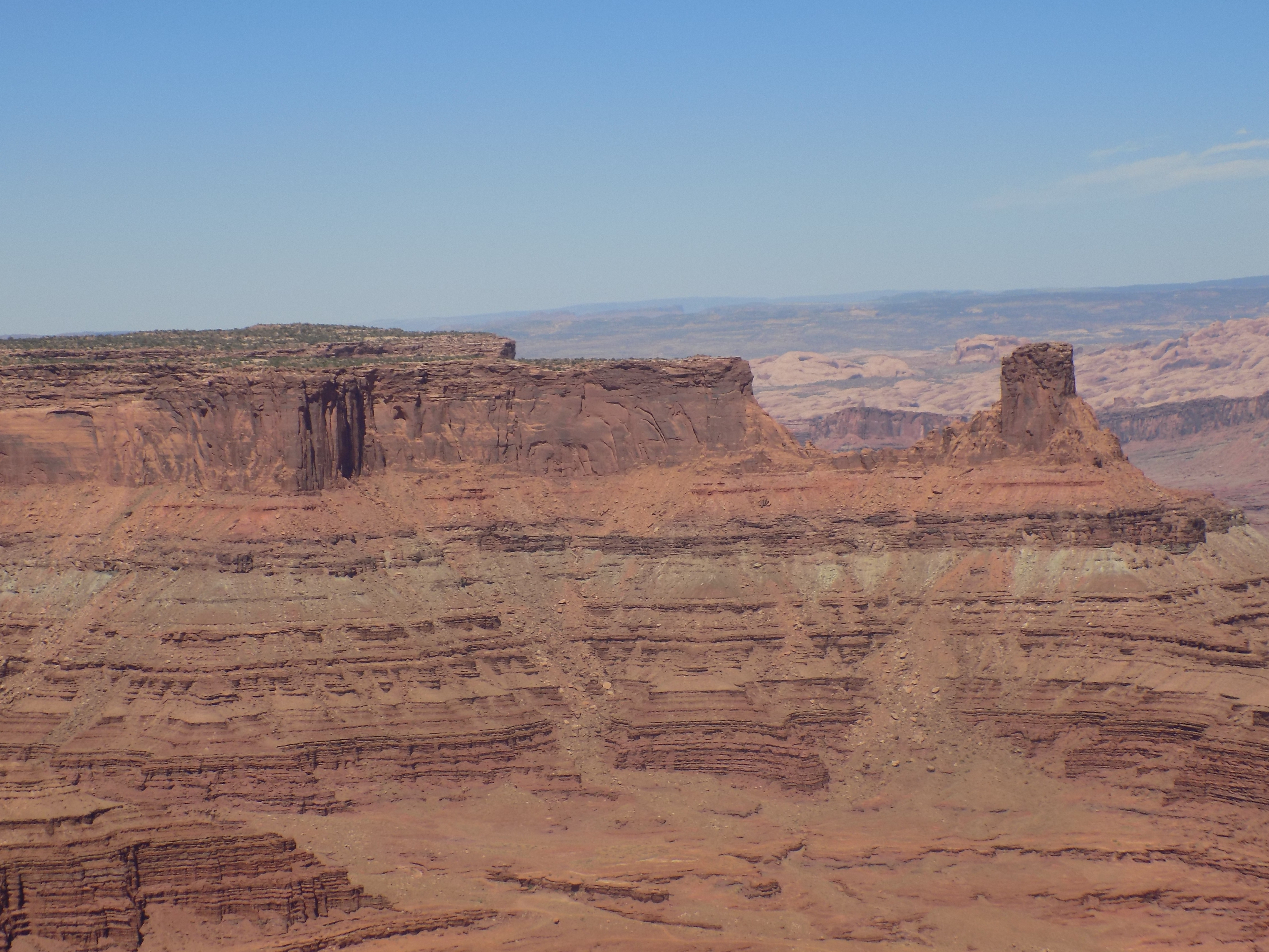
So why my obsession with Dead Horse Point? Well, it does have some impressive views like the one with the Colorado River below (or the others here)
but that wasn’t the reason at the top of the list. Before I reveal that, I’ll tell you how it came to have such an unusual name. (I was curious so I assume you might be, too.) This is from the park’s website:
According to one legend, around the turn of the century the point was used as a corral for wild mustangs roaming the mesa top. Cowboys rounded up these horses, herded them across the narrow neck of land and onto the point. The neck, which is only 30-yards-wide, was then fenced off with branches and brush. This created a natural corral surrounded by precipitous cliffs straight down on all sides, affording no escape. Cowboys then chose the horses they wanted and let the culls or broomtails go free. One time, for some unknown reason, horses were left corralled on the waterless point where they died of thirst within view of the Colorado River, 2,000 feet below.
The main reason I wanted to come to Dead Horse Point was to take a picture like this one:
Some of you might make the connection but I suspect most of you are still baffled. Although I couldn’t quite match the camera angle (mine from the rim, the movie from the floor), this is the backdrop for the final scene from a 1991 movie – and you know how I love visiting movie sites. So, let me show you a screen capture.
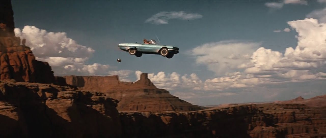 And, for those of you who still don’t recognize it, it’s Thelma and Louise.
No news.
You might recall that four trip days and many trip posts ago when I visited Petrified Forest I wrote, “My next stop at Newspaper Rock would affect the Utah portion of my trip.” Getting close up to the petroglyphs in Monument Valley also played a part in my next decision.
It’s about a two-hour drive from Dead Horse Point to Blanding and when I initially planned the trip, I’d included a small 25-mile round trip detour that comes up about two thirds of the way between the two. That stop was to have been at Utah’s Newspaper Rock State Historic Monument. In Navajo, the rock is called “Tse’ Hone” (rock that tells a story) and the website Desertusa has this description:
Newspaper Rock is a petroglyph panel etched in sandstone that records perhaps 2,000 years of human activity in the area. Etched into the desert varnish are symbols representing the Fremont, Anasazi, Navajo and Anglo cultures. The exact nature of these symbols’ meaning is still not clearly understood. But they are typical of many sites throughout the U.S. in their use of universal symbols, be it graffiti or a true “newspaper,” recording events of the times and earlier.
One aspect that makes this worth a detour is that unlike in Petrified Forest, here, one can approach very near the rock face and get a clear sense of the symbols chipped into it. The main attraction, though, is the sheer number – more than 650 – of the images in a concentrated space.
However, just as the very young can become quickly bored in some situations, as I’ve aged, I find that I can become relatively quickly jaded. I’d seen a dense concentration of petroglyphs in the Petrified Forest and seen them in close-up in Monument Valley. Nearing the end of this two week journey the detour to see more rock carvings seemed much less enticing than it had when I first learned about the site. Oooh-aah.
For me, the decision was relatively easy. Drive on. Check in at the motel. Chill out.
In the concluding series of posts, I hope to help you discover that, while my next stop is called Blanding, it’s far from bland.
-

Here are the songs from the México City and México City Olympics posts
May 18, 2026 -

Notes on the XIX Olympiad – the quiet protest – (México City and Me addendum three)
May 18, 2026 -

Notes on the XIX Olympiad – Successes, failures, and a Flop – (México City and Me addendum two)
May 15, 2026 -

Notes on the XIX Olympiad – Understanding Carlos and Smith – (México City and Me addendum one)
May 13, 2026 -

Y no te puedo hallar
May 11, 2026