The Salmon Arches – Part 2
The rest of the supporting cast.
More than 100 million years before the Entrada Sandstone (that I introduced at the end of the previous post) formed as part of a massive desert, this area was a foreland marine basin that was a large evaporative sea covering much of southeastern Utah and southwestern Colorado. When the sea evaporated, it was replaced by shifting dunes of fine-grained sand. The grains were nearly spherical, so when they packed together, they formed a type of rock that’s very porous (think of marbles in a jar).
By contrast, the Navajo layer beneath it contains a mix of sand and clay. Because clay particles are much smaller than sand grains, a lot of them can pack together and fill in gaps between the sand grains. This makes the rock denser and less porous than purer sandstone.
Dig deep enough below the surface and you’ll find a thick layer of salts in a specialized salt bed called an evaporite. An evaporite is basically what it sounds like it would be – a mineral found in the sedimentary deposit of soluble salts that results from the evaporation of water. And where do you find most evaporites? If you answered, “a marine basin where evaporation exceeds inflow,” you aced the quiz.
Under pressure, salt is unstable. At Arches, as the tons of rock above it squeezed the salt, it flowed and bulged upward, in an anticline which is a type of fold in the earth that is an arch-like shape with its oldest beds at its core. A typical anticline is convex. For the more visual among you, here’s an example of an anticline (the photo is from Wikimedia and was taken on Route 23 in New Jersey).
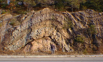
The hinge or crest is the location where the curvature is greatest, and the limbs are the sides of the fold that dip away from the hinge. Here’s where the evaporites played their part in Arches. Their presence formed more unusual salt anticlines or linear regions of uplift creating long domes that cracked the rock layers.
I don’t know if it was simply a matter of coincidental timing or my dawdling driving had sufficiently delayed my arrival at the park entrance but when I reached it, I encountered a delay even longer than the one I’d faced at Zion. Fortunately, once I got through the entrance station and made a brief orientation stop at the Visitor’s Center, the traffic thinned fairly quickly.
Once in the park, the first viewpoint gives you a chance to view the Moab fault. I’m not great at spotting these but I have a picture from the website paleoseismicity.org that shows the fault. And this is where we learn to hope that Godot (in the form of an earthquake) will continue to keep us waiting.
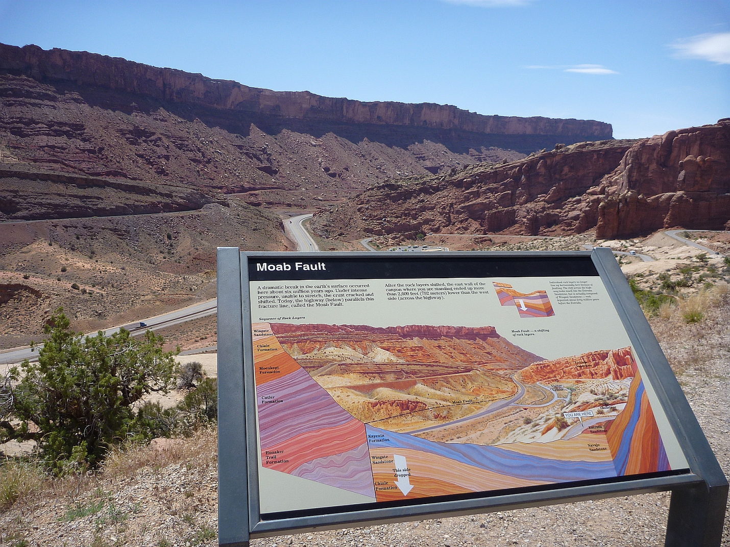
You see, while there is a fault line clearly visible, and earthquakes played a crucial role in uplifting the Colorado Plateau, one reason the arches are still standing is the long geological stability – or lack of seismic activity in the region. A temblor would cause the collapse of many, if not all, of the arches as easily as London Bridge falls in song. Fortunately for those who enjoy places like this, there hasn’t been an earthquake here for at least 50,000 years.
Where is everybody?
Before I bring on the star of the show in making Arches, I’d like to take a short intermission and bring up another point that makes Arches different from other parks I’ve visited. People lived (and still live) in the Grand Canyon. People lived (and still live) in Canyon de Chelly and people lived in Zion. Ancestral people passed through Arches but there’s almost no evidence that they ever dwelled here.
Here’s the evidence we do have. Hunter-gatherers migrated into the area about 10,000 years ago – a millennium or so after the end of the most recent glacial age. In Arches, they found pockets of chert and chalcedony which are two forms of microcrystalline quartz they used to make stone tools but that’s all the evidence they left behind. This, from the evidence we currently have, it appears they made their tools, left their dross, and moved on.
It wasn’t until sometime between two thousand and three thousand years ago that the regional nomadic hunters and gatherers began cultivating such plants as domesticated maize, beans, and squash. However, most evidence locates the closest settlements of Ancestral Puebloans in the Four Corners region which is 150 miles south of Arches and places the villages of both Ancestral Fremont and Utes closer to today’s central Utah.
Very few dwellings have been found in Arches or in nearby Canyonlands National Park but these ancestors did leave behind a noteworthy amount of rock art by chipping away the desert varnish on exposed rock surfaces to create petroglyphs similar to those we saw first in the Petrified Forest.
And now – the star of the show – Water!
Although the area is considered a desert, the 8-10 inches of precipitation that falls every year is the star in this rock shaping show. Here’s how: Drops of rainwater easily soak into the porous Entrada sandstone and then slowly dissolve the calcite bonding the sand. This effectively rots the rock from the inside out and creates water puddles just above the denser layer. Just as food caught in an inconvenient place in your teeth can erode them to the point where it creates a cavity, the trapped water in the clay and sandstone acts in similar fashion.
Rain erodes the rock and carries sediment down washes and canyons to the Colorado River which forms much of the southern boundary of the park. Any winter precipitation eventually melts and, as the winter snowmelt pools in fractures and other cavities it freezes, expands, and breaks off chunks of sandstone in the process generating a type of frost weathering akin to what we saw at Bryce. Small recesses develop and grow bigger with each storm. Little by little, this turns fractured rock layers into fins. The fins enlarge and rock falls away in one of the two processes that ultimately create the arches. Arches also emerge when potholes near cliff edges grow deeper and deeper until they wear through the cliff wall below them.
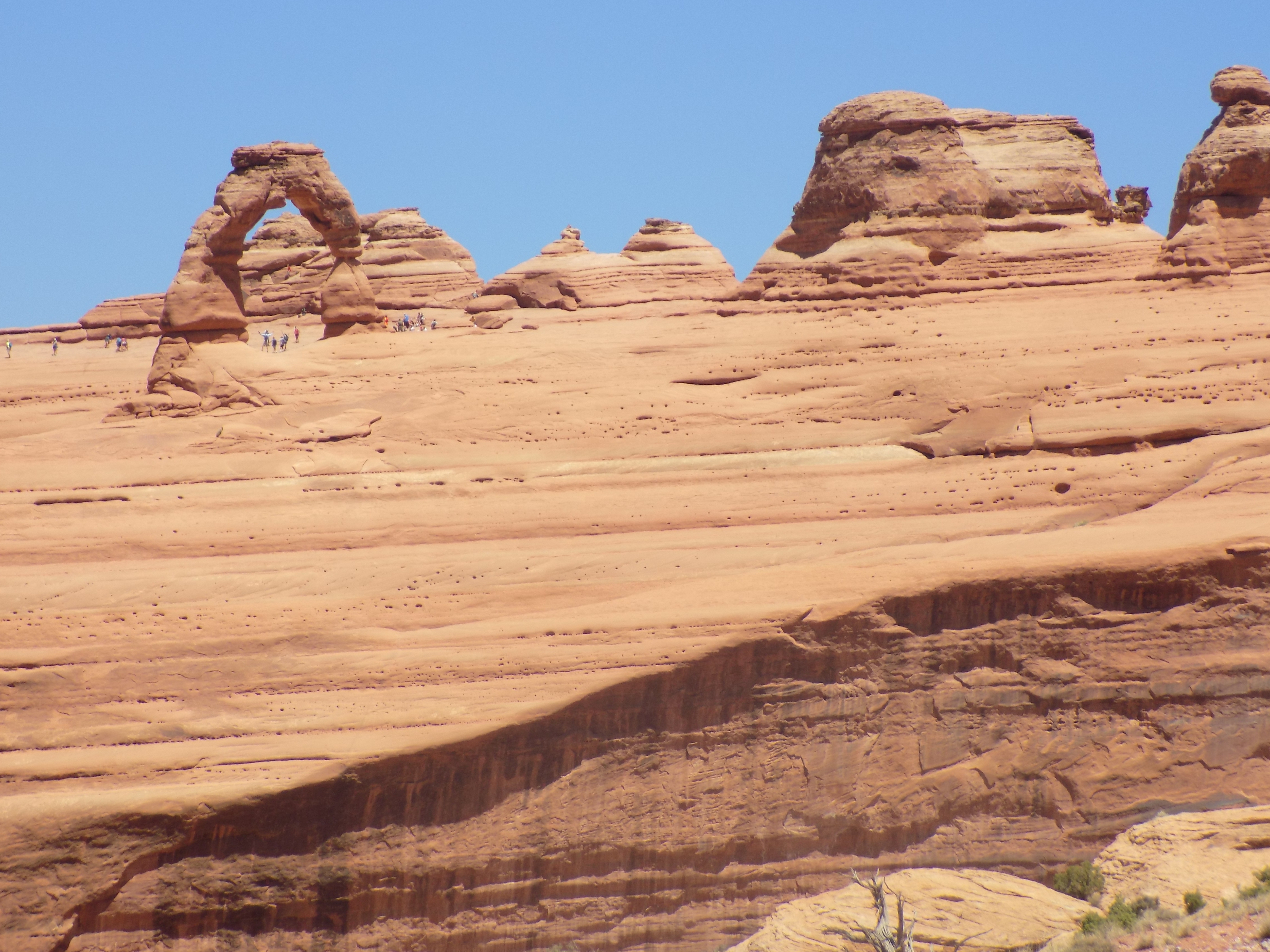
While I was able to see a few of the park’s more iconic formations, many others weren’t accessible because sections of the park were closed to traffic and I had long since passed the point of considering any strenuous hiking on this trip. Still, before I wrap up this visit, I’ll drop one more photo – of the iconic Delicate Arch here
and the link to the rest here. (Had I made the hike to and beyond the Delicate Arch, I might have had a look into Seven Mile Canyon where they filmed the opening of Indiana Jones and the Last Crusade. Didn’t do it.)
I leave you with this fact: The arches themselves are fragile and impermanent. Even with no seismic activity, 43 arches are known to have collapsed since 1977. As will be the case with the hoodoos in Bryce over time, the same forces that create the arches of Arches will continue to widen them until they suffer the same fate as the Azure Window and crumble.
-

Here are the songs from the México City and México City Olympics posts
May 18, 2026 -

Notes on the XIX Olympiad – the quiet protest – (México City and Me addendum three)
May 18, 2026 -

Notes on the XIX Olympiad – Successes, failures, and a Flop – (México City and Me addendum two)
May 15, 2026 -

Notes on the XIX Olympiad – Understanding Carlos and Smith – (México City and Me addendum one)
May 13, 2026 -

Y no te puedo hallar
May 11, 2026