The Salmon Arches
While today is technically the antepenultimate day of the trip it is, for all practical purposes, the penultimate day because Monday is almost entirely devoted to traveling home. I’ll have to drive several hours to reach my first and principal stop for the day – Arches National Park – but the route there also brings me close enough to a pair of roadside attraction stops that I’ll make the appropriate detours.
I’ll end the day at the Stone Lizard Inn in Blanding and, in addition to visiting Arches will backtrack to Dead Horse Point State Park. With my visit to Arches, I will have dropped in on three of the five national parks – Arches, Bryce, Canyonlands, Capitol Reef, and Zion – deemed by some as Utah’s “Mighty Five.” Given its proximity to both Arches and Dead Horse Point I could have easily included Canyonlands but, as odd as this might seem, I was teetering on the verge of canyon saturation and, while Dead Horse Point is also a canyon, I had a very specific reason for wanting to visit there.
Both of the intermediate stops were merely of the photo op variety and I didn’t anticipate they’d cause any significant delay in arriving at Arches. As things turned out, I found the first so disappointing I didn’t even bother to take a picture. (This was at the headquarters of Blendtec in Orem to see “the world’s largest blender”. It was just a glass (or plexiglass) structure with a faux handle above the entrance. Now, if it had had blades…)
I made stop number two in Helper, Utah where, had I arrived later in the morning, I could have spent some time visiting the Western Mining & Railroad Museum. The museum has a simulated coal mine in the basement and a room on the third floor dedicated to the 1924 Castle Gate Mine disaster that killed more than 200 miners. However, the museum didn’t open until 10:00 or about half an hour after I arrived and, after the incident at Zion, I was disinclined to wait and delay my arrival at Arches. Still, I was able to see the 18-foot-tall statue called Big John so there I had my photo op.
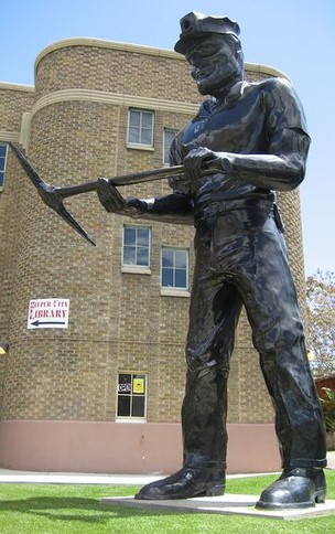
The town built Big John in 1964 about the same time they were planning the museum. He’s made of rails, spires, and plates from the Castle Gate Mine. For those of you who are wondering, he is, indeed, named for Jimmy Dean’s 1961 hit song.
At a fault but not at fault.
Helper is about the halfway point between Salt Lake City and Arches and, with a strong signal from KUER (Salt Lake City’s NPR affiliate) combined with my feeling that I was running a bit ahead of schedule, I eased up on the gas pedal and drove at a relaxed pace enjoying the feeling of leisure even if it wasn’t the most beautiful road of the trip. I don’t know if 20 minutes or half an hour would have made a difference but as it turned out, I should, indeed, have taken the Zion lesson more to heart. While I’m driving, I’ll tell you how Arches came to be.
You can find natural stone arches in many places around the world. One of the more famous on the east coast of the US, Natural Bridge, Virginia is about 200 miles southwest of my home in Silver Spring, Maryland or a bit less than halfway between Harrisonburg and Roanoke. Another, known as the Azure Window on the Maltese island of Gozo ( that I visited in 2012), showed us just how fragile these formations can be when it collapsed during a storm earlier this year (2017).
Fans of the HBO series Game of Thrones might recognize it:

As I write this, there are, according to the Park Service, more than 2,000 documented arches in the National Park bearing that name thereby making it the densest concentration of natural stone arches in the world. Now, you might have some trouble finding all of them if you went on such a quest. While the largest arch spans a distance of more than 300 feet, the National Park Service website officially describes others as “sliver-thin cracks.”
Many of the same forces working throughout the region – and with which you are now familiar – played supporting roles in creating the landscape at Arches. But other forces, beginning with the composition of the rocks, formed an ensemble cast centered around one clear star in this geologic drama. Let’s begin with the age of the rocks.
There are places in Arches where the vista certainly evokes Monument Valley. For example, there’s a formation called the Three Gossips
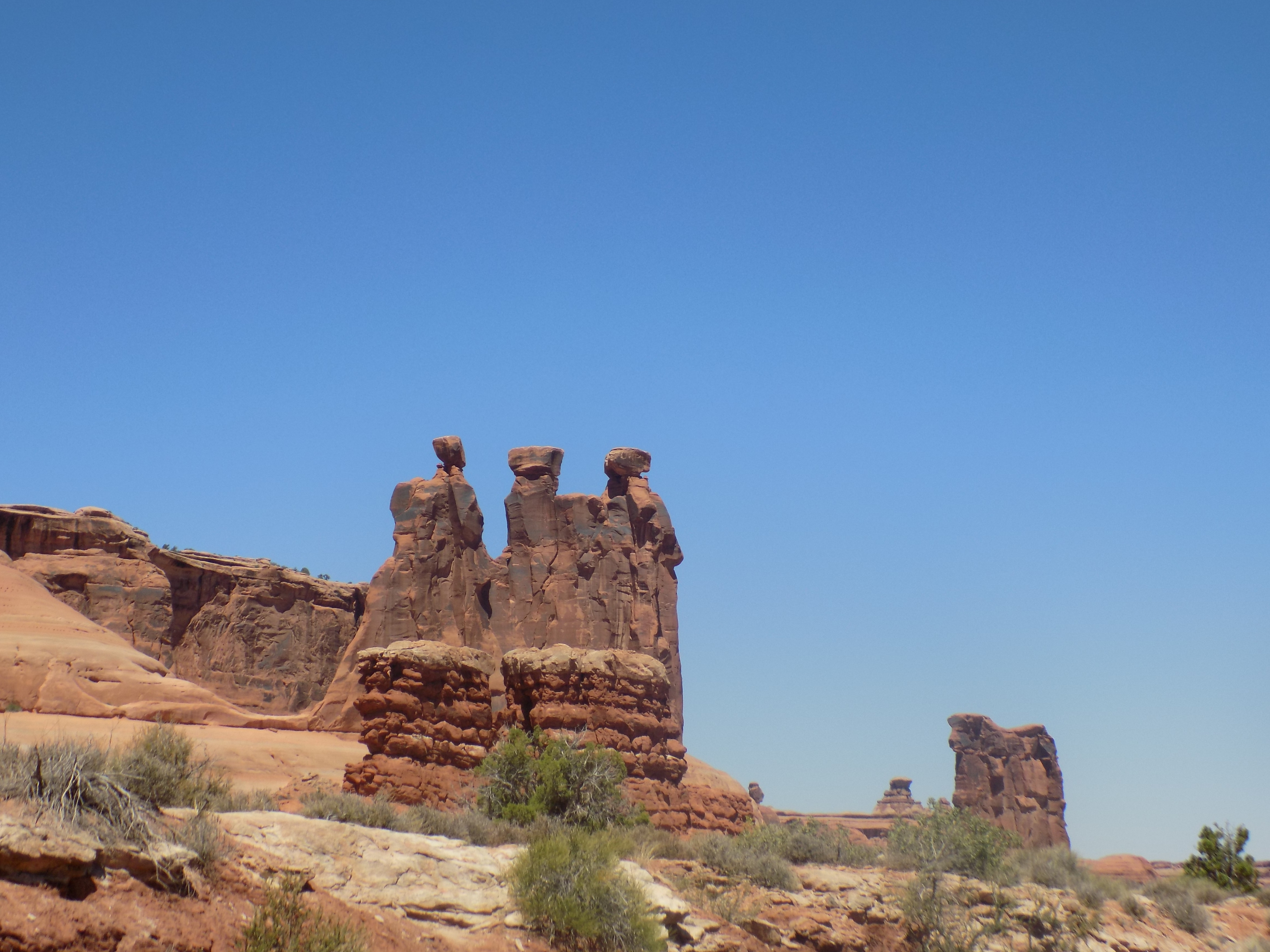
that somewhat calls to mind the Three Sisters. However, you may recall that all of the formations in Monument Valley are part of the Cutler Group sandstone. That’s not the case at Arches. The sandstone of the Cutler Group was laid down in the Permian Age roughly between 250 million and 300 million years ago. Arches is far younger. In fact, the oldest sandstone we see there is Navajo Sandstone which dates to the early Jurassic of 190 million years ago. This sandstone will be buff colored.
But there’s another, more prominent type of sandstone in Arches. This is Entrada Sandstone which was deposited in a conforming layer (recall the Great Unconformity we saw in the Grand Canyon) atop the Navajo Sandstone between 180 million and 140 million years ago. Entrada Sandstone has a color akin to salmon flesh. Nearly all the park’s visible formations are comprised of one or both of these materials. (So, if you want to visit a real Jurassic Park, Arches is your place.) As I continue the process of shortening the original posts to a more manageably readable length, we’ll meet the rest of the cast involved in staging this landscape in the next post.
Note: In keeping with my 2022-2023 reformation of the blog into shorter entries, backdated to maintain their sequence, any comments on this post might pertain to its new configuration. See the full explanation in the post Conventions and Conversions.
-

Here are the songs from the México City and México City Olympics posts
May 18, 2026 -

Notes on the XIX Olympiad – the quiet protest – (México City and Me addendum three)
May 18, 2026 -

Notes on the XIX Olympiad – Successes, failures, and a Flop – (México City and Me addendum two)
May 15, 2026 -

Notes on the XIX Olympiad – Understanding Carlos and Smith – (México City and Me addendum one)
May 13, 2026 -

Y no te puedo hallar
May 11, 2026
2 responses to “The Salmon Arches”
Amazing views, Todd. I was wondering how pioneers may have reacted to this if they were so unfortunately to venture that way. (Any commentary about wagon train crossings?).
It looks both majestic and bleak.
I didn’t realize this was one of the location that Game/Thrones used. (as a fan, I appreciate the illustration.)
The route of the LDS Pioneers wouldn’t have brought them near Arches. They followed the Platte River north through Nebraska and into Wyoming going as far north as Casper before continuing west and turning south through Fort Bridger more or less following the route traversed by I-80 from, say, Rock Springs, WY into SLC.
This crossing was something of a wagon train but people were also in horseback, in buggies, etc. I suspect that this was, because of the skills and insight of Brigham Young, better organized and provisioned then most similar crossings.
As for GOT, you might recall that Dubrovnik also serves (served?) as a location. If you missed it, I wrote about it in this post: https://gruncleodd.com/2016/09/19/dubrovnik-knacks-seeking-a-kodak-moment/