
Triangle of Confusion and making the Mostar of a long bus ride – part 3
Shaping Bosnia – 1991-1995
Let’s recap some of what we know to prepare for the discussion of the 1991-1995 wars. After World War II, Tito controlled the republics with a strong personality (aided by a strong internal security force). With no strong leader in sight who shared his vision of keeping the southern Slavs united, he drafted a constitution in 1974 that granted the republics the constitutional right to self-determination, including a right to secede thereby laying the foundation that the Republics would use to justify their secession. However, the constitution also had one article that required the consent of all republics and provinces before the borders of Yugoslavia could be altered and another that gave the Yugoslav Assembly the power to determine alterations in the state’s boundaries. These articles created some ambiguity regarding the possibility of unilateral secession. This wasn’t a good thing.
The 1974 Constitution also outlined governing plans for Tito’s succession. This came into play following his death in 1980. It proposed a rotating Presidency. Each of the republics and provinces would preside for a year over a sort of Assembly. This created a situation where governmental decision making became ineffective and overlong. Also, since each President tried to guide policy in favor of his region, it created an inconsistent federal policy leaving the country largely ungovernable.
Perhaps fueled at least in part by a rising tide of nationalist leaders like Milošević in Serbia and Franjo Tuđman in Croatia, by 1991, barely six percent of the population self-identified as Yugoslavian. And, of course, this is when we see the republics begin to secede beginning with the two wealthiest – Slovenia and Croatia – followed by Macedonia and B&H. Fighting in Slovenia and Macedonia was minimal. Fighting in Croatia was considerable and the war in B&H was the most severe.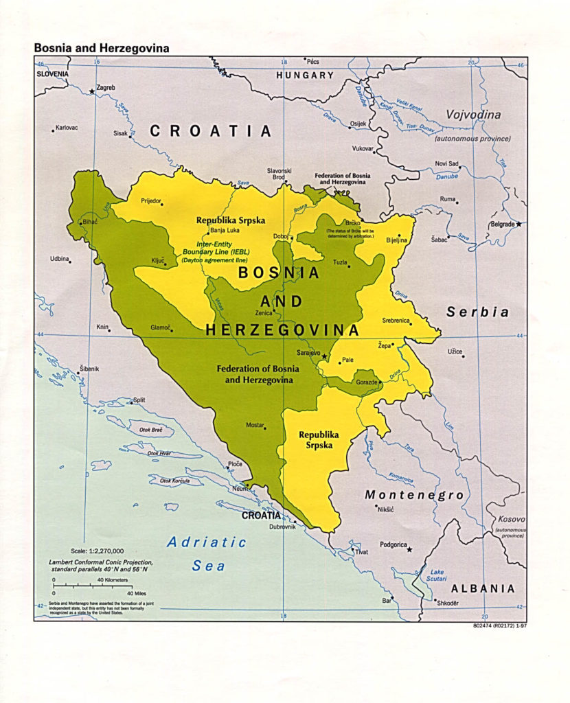 It’s important to note that when B&H announced its intention to hold a secession referendum, the country’s Orthodox (read Serbian) minority who had already been declaring Serbian Autonomous Regions in B&H and, hoping to delegitimize the vote, unanimously refused to take part. Many Serbians relocated either by force or by choice to the yellow areas on the map. By this time, they clearly saw themselves as Serbians rather than as Bosnians. When the U S and European Community recognized B&H as a sovereign nation, the Serbs attempted to secede thereby prompting the aggressive intervention ordered by Milošević under the pretense of protecting Serbs.
But Milošević wasn’t alone in intervening in B&H. Because many of the Catholics in Herzegovina similarly viewed themselves as Croatian, Croatia under Tuđman also saw an opportunity for a territory grab and invaded from the south. The underlying idea seemed to be that Serbia would control what has now become Republika Srpska, Croatia would expand to take all or most of the Herzegovina region and Bosnia would be left either to accede to one or the other or to fend for itself.
In a previous post, I included the video of Ratko Mladić on the eve of the Srebrenica massacre that finally prompted significant intervention by the U S and the international community. This eventually brought the parties to Dayton, Ohio in November 1995 where they would be quite isolated. After about three weeks of nearly constant negotiation an under the insistent guidance of Richard Holbrooke, the parties hammered out the final agreement that led to today’s blobby and fragmented B&H.
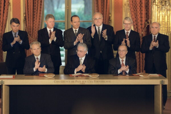
[Signing of Dayton Accords from Wikipedia – Public Domain.]
All the parties, Croats, Serbs, and Bosniaks needed to be satisfied as to the amount and nature of the territory they controlled and the protection of the various ethnicities. The Serbs and Bosniaks both gained a bit of territory while the Bosnian Croats lost some of their footprint. The Bosnian Serbs controlled about 46 percent of the territory before the war and that increased to 48 percent after the war but what they gained in quantity, they lost in quality as the Bosniaks gained some of the resource rich territory in the Sarajevo district. The Bosnian Croats were the big losers in terms of territory dropping from 25 percent before the war to 21 percent after it.
I don’t want to overwhelm you but I need to cover – or at least mention – two last topics. The first is something I’ll discuss in some detail later is the Dayton Accords. While probably being among the most impressive achievements and examples of conflict resolution ever crafted, it created an unwieldy governing system that should have been transitional and eventually subject to internal renegotiation. The governmental structure the accord put in place, and that remains in effect in 2016, continues to retard the development of B&H to this day. Here’s a bit of the reason why.
*Census or Senseless.
Before conducting its first post war census in 2013, B&H’s most recent census was taken in 1991. In that census, Bosniak Muslims made up 43.5 percent of the population, Orthodox Serbs 31.2 percent and Croatian Catholics 17.4 percent. The results (shown in a previous post) were finally made public on 30 June of this year (2016). There’s little question that B&H lost a significant part of its population because of the war so some demographic shifts should be expected. The Dayton accords based power sharing upon the relative populations of the country’s three main ethnic groups at the time of the most recent census. The accord left unaddressed any changes to the power structure resulting from future censuses.
When no group has a majority, the power sharing situation remains complex but retains some relative balance because no one group can act unilaterally and it’s this constant struggle to form coalitions that retards the government from implementing many policies that would be beneficial to the populace. They require support from at least one other group. The new census, showing the Muslims comprising 50.1 percent of the population dramatically shifts the balance of power effectively turning B&H into a Muslim state with two ethnic minorities rather than the three minority state it was at the time of the 1991 census.
The authorities in the Republika Srpska needed about 20 nanoseconds to reject the results of the census. Their main complaint was that the census counted people who fled Bosnia during the war and now live abroad. It’s probable that large majority of people living abroad are, in fact, Muslims and Croats who fled what is now Serb controlled territory and counting them would further weaken the Serbian grip within their region because in the census 16 and a half percent of the population in Republika Srpska is not Serbian.
Brčko is not a tree.
The last item I can’t omit in the discussion of B&H’s map is ignoring one other element that the Dayton accords never finalized – the status of the Brčko District. (it’s pronounced BIRCH-ko.) You can’t see it very well on the map above but it’s in the northeast portion of the country. Here’s a close-up courtesy of Wikipedia and PANONIAN:.
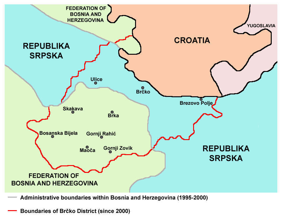
This bizarre little corner of the world (or at least bizarre little corner of B&H) is a self-governing administrative unit as well as being a political territory over which multiple sovereign powers (in this instance the Federation of B&H and the Republika Srpska) formally agree to equally share sovereignty and exercise their rights jointly, without dividing it up into ‘national’ zones. (Interestingly, in diplomatic circles the technical term for this is condominium.)
The Dayton Accords were signed in 1995 with the status of the Brčko District unsettled. Four years later after a fairly lengthy arbitration process undertaken by the High Representative for Bosnia and Herzegovina the odd solution established the Brčko District. The Federation of B&H claims 52 percent of the territory and Republika Srpska 48 percent in an area that’s governed by neither but by both simultaneously. To me, this seems like the sort of solution that could only happen in a place as confusing as B&H and yes, some of the political decisions taken over the past 17 years are as confusing as you’d expect them to be. The EU continues to maintain a peacekeeping force in the district.
I promise to get us to Mostar in the next entry.
-

Here are the songs from the México City and México City Olympics posts
May 18, 2026 -

Notes on the XIX Olympiad – the quiet protest – (México City and Me addendum three)
May 18, 2026 -

Notes on the XIX Olympiad – Successes, failures, and a Flop – (México City and Me addendum two)
May 15, 2026 -

Notes on the XIX Olympiad – Understanding Carlos and Smith – (México City and Me addendum one)
May 13, 2026 -

Y no te puedo hallar
May 11, 2026