Triangle of Confusion and making the Mostar of a long bus ride – part 2
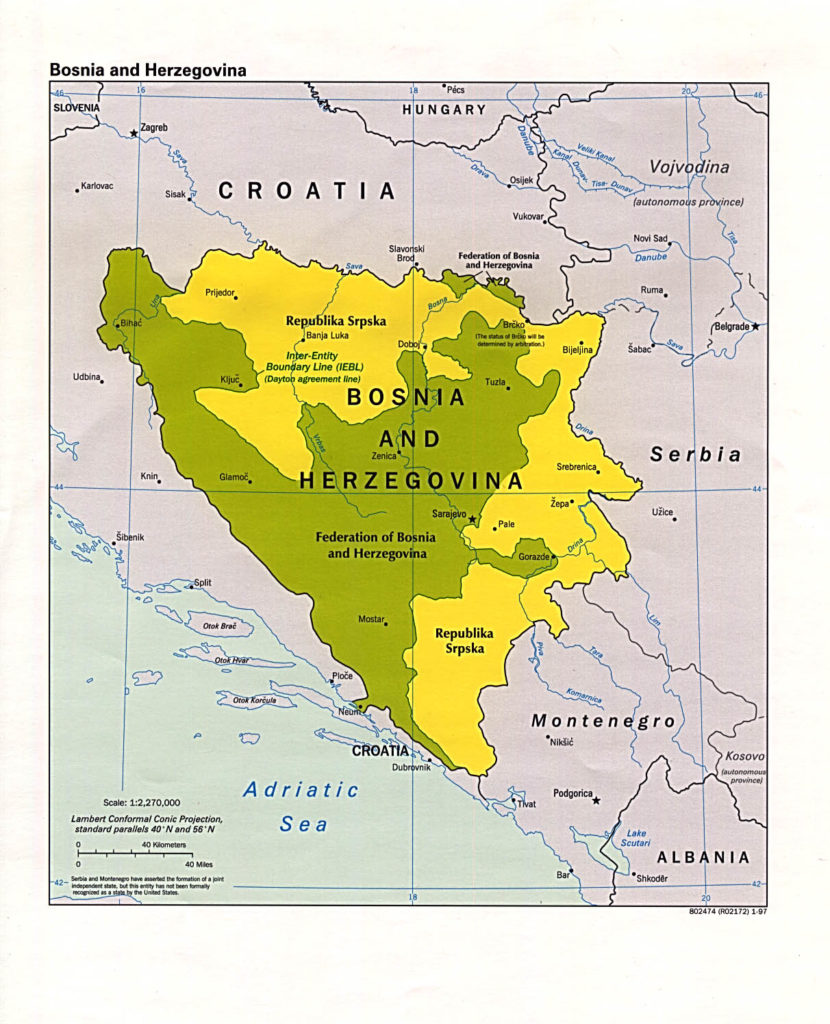
In tracing the history behind the odd 20-kilometer wide strip of land that’s part of Bosnia and Herzegovina (B&H) and two Croatian counties, I ended the previous post when the 1878 Treaty of Berlin gave Vienna control of all of B&H. We need to, as we will often do, keep this map in mind.
 In 1918, Habsburg rule ends and Neum becomes part of the Kingdom of Serbs, Croats, and Slovenes which in 1929 then became the Kingdom of (all together now) Yugoslavia. There’s a period of relative stability between World Wars One and Two and Yugoslavia survives WW II more or less intact thanks largely to the efforts of one Josip Broz Tito who led the Yugoslav Partisans in defense of their homeland.
I’ll get to more about Tito when we return to Croatia and visit Kumrovec, his birthplace. For now, it’s enough to know that Tito held the fractious factions of Southern Slavs (Yugoslavia means “land of the Southern Slavs”) together from the end of World War II until his death in 1980 three days shy of his 88th birth anniversary. He managed this in part by maintaining traditional boundaries and since B&H and Croatia were Republics in a single Yugoslavia, keeping this small seaside strip nominally part of B&H made sense for Tito. In the post about Islam’s arrival in the Balkans, I briefly mentioned the Constitution of 1974 that provided the mechanism through which the Republics could seek their independence from the Yugoslav Federation and it becomes important at this point of the story.
After Tito died, ethnic tensions rose and a fractious but inexplosive decade followed. Then, in December 1990, Slovenia, followed in very short order by Croatia in May 1991 held the requisite referenda and declared their independence from Yugoslavia. Macedonia followed suit with their declaration in September 1991 and finally Bosnia and Herzegovina in April 1992. This left Serbia and Montenegro to form an alliance called the Federal Republic of Yugoslavia (aka “rump Yugoslavia”) with Slobodan Milošević as President and claiming to be the legal successor to the now failed Yugoslav state – a claim the international community never recognized.
While all of this is happening, the European Economic Community set up the Arbitration Commission of the Conference on Yugoslavia. (I will refer to it as it was commonly known – the Badinter Committee for its President Robert Badinter.) The Badinter Committee met from late 1991 to the middle of 1993 just as war was breaking out all over the peninsula. Their first ruling pertinent to the present discussion came in 1991 when they declared that “the Socialist Federative Republic of Yugoslavia is in the process of dissolution.”
In January 1992, they made another important ruling this time regarding borders: “The boundaries between Croatia and Serbia, between Bosnia and Herzegovina and Serbia, and possibly other adjacent independent states may not be altered except by agreement freely arrived at…Except where otherwise agreed, the former boundaries become frontiers protected by international law.”
Seven years later in 1999, Croatia and B&H signed an agreement regarding their borders. B&H wanted to maintain their albeit tiny connection to the Adriatic because it permits them to be defined as a maritime nation and fuels their ambition to turn Neum into a major port. Among the stipulations in that 1999 agreement were that the borders be defined on the basis of the border situation at the time of the cessation of existence of SFR Yugoslavia in 1991 and, of the mutual recognition between Republic of Croatia and Republic of Bosnia-Herzegovina in 1992.
For reasons I’ll get to later, Croatia was the first country to recognize and independent B&H. The 1992 recognition coupled with the latter 1999 agreement means that today Croatians wanting to drive from Split to Dubrovnik must pass through B&H and back into Croatia and Americans on a 40-passenger bus wanting to go to Mostar from Dubrovnik have to do the same but they also need to enter B&H a second time. So,
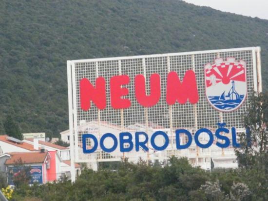
as the sign says, Welcome to Neum.
In truth, this situation isn’t good for the Croatians beyond the traffic issues attendant on having to pass through a two-lane international border crossing to drive from one county to another in their own country but also because in order to complete their EU membership and become part of the Schengen Area their country must be contiguous. Fortunately, the Croatians designed a (somewhat controversial) way around this dilemma. Although the EU maintains more than one solution is possible (a tunnel, for example), the Croatian government claims this as the only acceptable alternative.
Here’s an enlarged (from Wikicommons) section of the map above:
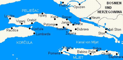
Note the Pelješac Peninsula that’s part of Croatia that juts into the Adriatic at Mali Ston just south of B&H. The plan is to build a bridge at the map’s red line reconnecting the peninsula with the mainland thereby allowing the Croatians to bypass B&H and meet that EU requirement of being contiguous. Unfortunately, this is the Balkans where nothing is ever simple.
Construction of the bridge began in 2007, slowed in 2009 due to the economic crisis and was halted in 2012. Environmentalists within Croatia objected because of the possible impact the bridge would have on the Bay of Ston. Bosnians began to haggle over shipping lanes, international waters and the height of the bridge. As I write this, construction remains delayed.
(Update: the Pelješac Bridge opened on 26 July 2022.)
Why is the internal map of B&H so blobby?
In order to understand the “blobby-ness” of the map of B&H We’re going to have to again dip our collective toes in the waters of the 1991-1995 wars. As I have previously, I’m going to try to avoid a headlong dive into this whirlpool not only because people far smarter and with significantly broader knowledge than I, have covered the topic in great depth but also because I hope not to shred your interest in continuing to read this blog on the jagged rocks lurking below the surface.
I wrote several posts trying to provide a bit of insight into not only how three religious groups came to occupy the Balkan Peninsula but how the manner of their ascension sowed the seeds of the conflicts that persist to this day. It’s also important to know – and it should be somewhat apparent from the historical patterns – that the groups tended to cluster geographically and, with one exception, are not close to being evenly disbursed across the various national borders.
Understanding that if one of these groups represent two percent or less of the country’s population, I will exclude it, here’s a rough idea of the current demographics:
Montenegro: 72% Orthodox; 19% Muslim; 3% Catholic.
Serbia: 84% Orthodox; 5% Catholic; 3% Muslim.
Croatia: 86% Catholic; 4% Orthodox.
Slovenia: 57% Catholic.
B&H: 50.1% Muslim; 30.8% Orthodox {Serbs}; 15.4% Catholic {Croats} (or is it?)*
Croatia wasn’t always quite as Catholic as it is today but I’ll return to that in another post. For the present time, notice how B&H stands out from the other four former Yugoslav Republics as the only one where you see a significant presence of all three religious groups. I’ve excluded North Macedonia [ 64% Orthodox; 33% Muslim] because we didn’t visit there and it played essentially no role in the 1991-1995 wars. (An interesting aside is that on most maps and in the U N the country is referred to as FYROM. This is an acronym of Former Yugoslav Republic of Macedonia. You might not find this in the U S because George W Bush signed a 2004 Executive Order recognizing the Republic of Macedonia. It’s mainly the Greeks who are behind this but it has no bearing here other than somehow being so typically Balkan. You can look up the controversy on your own if you’re curious. But if you go to Google Maps and search Macedonia, this is what you’ll see:
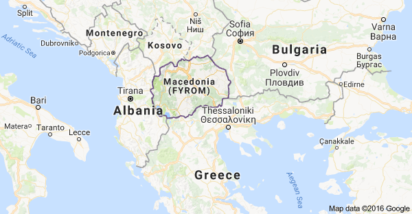
Update: In February 2019 FYROM reached an agreement with Greece and officially became the independent country of North Macedonia.)
Getting back to B&H’s “blobby-ness,” if you look again at the map at the top of the post, you’ll see the yellow area identified as the “Republika Srpska” and I hope your internal ear has made the connection between Srpska and Serbia. Although this wasn’t always the case, today, this area is populated almost exclusively by Orthodox Christians. Look at the area labeled the Federation of Bosnia and Herzegovina and draw a north-south line from where Croatia is marked on the Adriatic through Mostar to the Yellow area of the Republika Srpska, you’ve roughly identified the Herzegovina region. Nearly all the Catholics live here. The rest of the green area is where you’ll find most of the Muslims. So, just as the religions have generally grouped together in different countries throughout the Balkans and though they were majorities in their current areas, they have, since the nineties wars, clustered even more closely internally (usually not by choice) within B&H creating its “blobbiyness.”
-

Here are the songs from the México City and México City Olympics posts
May 18, 2026 -

Notes on the XIX Olympiad – the quiet protest – (México City and Me addendum three)
May 18, 2026 -

Notes on the XIX Olympiad – Successes, failures, and a Flop – (México City and Me addendum two)
May 15, 2026 -

Notes on the XIX Olympiad – Understanding Carlos and Smith – (México City and Me addendum one)
May 13, 2026 -

Y no te puedo hallar
May 11, 2026