It’s not Idaho, it’s Bosnia & Herzegovina
You might think I got a bit carried away in the previous entries but making sense of B&H is akin to sweeping up all the tiny shards from the crystal wineglass you just dropped. Just when you think you’ve got them all, you spot, or more likely, step on another. In today’s entry I’ll try to focus more on my travel experience. We’ll make a brief stop in Mostar before reaching the day’s ultimate destination – Sarajevo.
To begin, I’ll solve the puzzle of today’s title. Once we passed through the little strip of B&H that separates Dubrovnik and Neretva County from Split and Dalmatia County, we needed to remain on the Magistrala because our bus was too large for the interior roads of B&H to accommodate. So, after crossing back into Croatia, we eventually had to make a more formal border crossing into B&H.
Although this route is slightly longer in distance and time, it afforded us the chance to pass through (or by) the rather interesting town of Počitelj and the pronunciation (POH-chi-tel-ye) is, to my ears, close enough to Pocatello that, well, I just can’t help myself. (And hey, it could have been far worse, I could have gone with a mushroom pun.)
I won’t delve deeply into the history of Počitelj but the area was settled as a fortress in the early to mid-15th century. It was a strategically important spot and was under Hungarian rule in the latter part of that century. But guess who came along in 1471? If you thought Ottoman Turks, treat yourself to a prize.
The Ottomans hung around in Počitelj for more than 200 years and they were busy. They constructed several public buildings including mosques, an imaret (charitable kitchen), a mekteb and medresa (Muslim primary and high school), a hamam (Turkish bath), a han (inn), and the clock-tower.
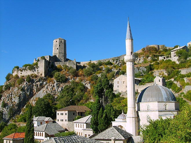 (This photo isn’t mine but is considerably better than the one I was able to shoot out the bus window.)
The Venetians pushed out the Turks in 1698 and, like the rest of B&H, the town came under Austro-Hungarian rule in 1878. The town held no strategic importance for the Habsburgs and, as a result, its status, population, and physical condition began to deteriorate. However, its diminished importance also meant that no Austrian “improvements” came to Počitelj allowing the preservation of the original urban architecture. Thus, today the town looks much like it did in the time of the Ottoman Turks.
Sadly, Počitelj was severely damaged from assault and bombing by Croatian forces. (Remember that one aspect of the war is that in the same way the Serbs were looking to annex the Republika Srpska, the Croats were seeking to add all or most of the Herzegovina part of B&H to their territory.) Shortly after the end of the war, in 1996, Počitelj was named as one of the world’s 100 most endangered cultural heritage sites by World Monuments Watch so some steps have been taken toward its preservation though we didn’t see them as we rumbled past.
Star of the town.
Follow the course of the Neretva River about 30 km north northeast of Počitelj and you reach the town of Mostar. If we were talking about France and I said Paris, the image most likely to pop into your mind would be the Eiffel Tower. Obviously, Mostar is neither as familiar nor as famous as Paris but for anyone who has been there or has thought about visiting, it’s equally likely that some variant of a single image will come to mind

and with good reason. Mostar, even down to its name, is all about its Stari Most or Old Bridge. The original stone bridge was built by the Ottoman Turks in 1566 and it’s considered among the most exemplary examples of Muslim architecture in B&H.
As a city that grew up on both sides of the Neretva River, it meant a bridge has always been a necessity in Mostar. A shaky wooden structure preceded the stone bridge that was commissioned by Suleiman the Magnificent. The name of the town comes from mostari – the native word for bridge keepers. It likely refers to the toll collectors who manned the span. A plausible alternative explanation exists, however. Mostari also refers to the two fortified towers – the Halebija tower on the northeast side and the Tara tower on the southwest corner – built to protect the bridge.
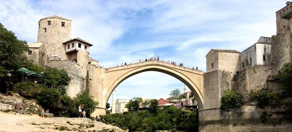
The 28-meter-long bridge spanning the river at a height of 20 meters has no foundations but rather abutments of limestone linked to walls along the riverside cliffs. The bridge was considered a wonder in its time and one 17th century Ottoman traveler described it as “like a rainbow arch soaring up to the skies, extending from one cliff to the other.”
Unlike our visit to Kotor, when we arrived in Mostar, we didn’t have to look too far or too hard to spot damage from the war. At the very beginning of our short walk to the market street and the bridge, we saw scars

and utter destruction.

Sadly, the bridge we saw and walked across and the bridge you see in the photos isn’t the same bridge that stood in that spot for 427 years. On 9 November 1993, Croatian forces deliberately destroyed the bridge targeting it with more than 60 shells. (You can see a photos of the destruction in Part 3.) Croat forces, claiming that the bridge was strategically important, admitted that the destruction was deliberate. Many historians doubt their claim and believe that the bridge held little strategic value.
After the war, the International Criminal Tribunal for the Former Yugoslavia (ICTY) determined that the bridge could have been considered a strategic target but that its destruction also caused disproportionate harm to the Bosniak citizens of Mostar. Many historians see it as an act of cultural property destruction or an attempt at killing memory by destroying evidence of a shared cultural heritage and, perhaps more importantly, peaceful co-existence.
The bridge we saw (and walked on over the steeply sloped, very smooth, and somewhat slippery stones) was reconstructed under the guidance and financing of several international institutions including UNESCO, the World Bank, the World Monuments Fund, and the Agha Khan Trust for Culture. The reconstruction used local material (including some original bridge stones recovered from the river) and Ottoman building techniques. The process required more than three years and it reopened in July 2004.
In order to better grasp what led to the destruction of the Stari Most, we need to take our first extended look at the war of a quarter century ago so please prepare yourselves for some unpleasantries.
-

Here are the songs from the México City and México City Olympics posts
May 18, 2026 -

Notes on the XIX Olympiad – the quiet protest – (México City and Me addendum three)
May 18, 2026 -

Notes on the XIX Olympiad – Successes, failures, and a Flop – (México City and Me addendum two)
May 15, 2026 -

Notes on the XIX Olympiad – Understanding Carlos and Smith – (México City and Me addendum one)
May 13, 2026 -

Y no te puedo hallar
May 11, 2026