Olympic Valley in the time before humans (Squaw Valley and Me supplement one)
The resort known as Squaw Valley when it hosted the 1960 Olympics is now called Palisades Tahoe. It’s new name blends two of the area’s prominent geographic features – the surrounding palisades of the Sierra Nevada range and Lake Tahoe that’s a mere eight miles east of the resort, is visible from the mountain peaks, and is North America’s oldest and largest Alpine lake. So, continuing the tradition of looking at how the geographic features that define the region of an Olympics host, it’s time to look at how these came to be.
What are palisades exactly?
While Palisades Park might have been immortalized by Freddy Cannon in 1962
(or the Beach Boys cover in 1976) the actual palisades aren’t a New Jersey Amusement Park. They are, rather, a roughly 20-mile line of steep basalt cliffs along the west side of the lower Hudson River. (The amusement park did sit atop these cliffs.) The Palisades Sill consists of magma that intruded among sandstones and shales of the Newark group. They are a 200-million-year-old diabase intrusion characterized by steep cliffs created when the magma cooled, contracted, and cracked into massive vertical, hexagonal columns hundreds of feet tall that later received an assist from erosion. (Diabase, also called dolerite, is a mafic, holocrystalline, subvolcanic rock chemically equivalent to volcanic basalt or plutonic gabbro and a pluton is an intrusive igneous rock body. The Palisades are a hypabyssal plutonic intrusion. This simply means it cooled at relatively shallow depths beneath the Earth’s surface)
[By Beyond My Ken – Own work, CC BY-SA 4.0.]
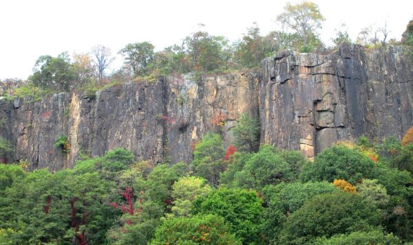
When early European explorers, notably Giovanni da Verrazzano in 1524, sailed past the The Palisades, they looked to him like a massive, defensive stockade built from upright logs and he applied the term to them. (Historically, the term palisade referred to a defensive wall or stockade made of upright wooden stakes.) As often happens, the specific proper noun gradually became a common noun. By the 19th century, geologists and the public alike started using it as a generic term to describe any similar line of steep, imposing, or columnar cliffs. In a northern California winter, they look like this.
[From Palisades Tahoe]
The plutons of the Sierra Nevada are granitic a trait that further differentiates them from the diabase of The Palisades. The principal mountain‑building phase that lifted these large granitic plutons is called the Nevadan orogeny, which occurred roughly 156–145 million years ago (Ma).
(The Nevadan orogeny marks the first significant phase of the overarching mountain-building event of western North America – the Cordilleran orogeny. The Nevadan was primarily driven by the collision of offshore volcanic island arcs and oceanic terranes with the western edge of the continent. The compression caused intense crustal shortening that resulted in tight, isoclinal folding, thrust faulting, and the widespread development of slaty cleavage. Massive volumes of magma intruded into the crust, forming large granitic batholiths across the region (found today in the Sierra Nevada, Idaho, and British Columbia.) High pressures and temperatures during these tectonic collisions caused widespread regional metamorphism, altering existing sedimentary and volcanic rocks into schists and phyllites. These events produced extensive intrusions (the Sierra Nevada batholith) that now form the coarse-grained granite exposed at Palisades Tahoe.
After the Nevadan phase, continued Cordilleran deformation (including effects related to the Sevier and Laramide orogenies), episodic plutonism, and much later Neogene to Quaternary normal‑fault block uplift shaped the present Sierra block geometry and steep eastern escarpment. In short, these Palisades are carved from Mesozoic granitoid plutons initially placed during Nevadan‑age magmatism. Subsequent uplift and jointing, combined with Pleistocene glacial sculpting produced the cliffs, slabs, and cirques characteristic of the resort area and that late uplift exposed and tilted the batholith that can be seen in the present time.)
Number 31
Why 31? It’s simple. By area, Lake Tahoe is the 31st largest lake in the United States. However, it’s the largest ancient lake in the US and, by volume, the largest natural fresh water lake west of the Mississippi River. In point of fact, it’s not particularly large. By area you could put more than 38 Lake Tahoes in Lake Erie – the smallest of the Great Lakes and nearly 166 into Lake Superior (the big lake they call Gitche Gumee). I started with this small an unimportant fact because I wanted to have a little fun.
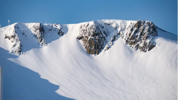
As you might recall from my trip to Lake Ohrid, geologically speaking, all of Earth’s lakes are young. Lake Zaysan in Khazakhstan is 65,000,000 years old and is, by far, the world’s oldest lake. Sub-glacial Lake Vostok in Antarctica holds the second spot at about 30,000,000 but on the surface you’d have to look at Kyrgyzstan’s Lake Issykul or Russia’s Lake Baikal (seen below)
to find lakes that are about 25-30 million years old. Lakes are generally so short-lived that lakes older than 1,000,000 years are considered ancient.
Why lakes don’t last
The terse explanation is that lakes form then slowly fill with sediment, drain, evaporate, or get reshaped by erosion and climate change over long timescales. Tectonic activity and glaciation are the two main lake forming processes though volcanic activity, meteor impact, certain river processes, or dissolution in karst terrain can also form natural lakes. Sometimes two or more of these processes will work in combination. (I don’t know if this makes other lakes jealous.)
Picture a lake as a cracked bowl that fills with water as rivers flow through the cracks and into the basin. (Direct rainfall adds some water but it’s not usually significant.) As the rivers flow in, they carry not only water but sediment leaving both behind. Sometimes they leave more sediment than water and this makes the lake gradually ever more shallow. They can also lose water through evaporation, outlet streams (most lakes are exorheic), groundwater drainage, or long-term climate shifts. Given enough time, a lake will become a wetland or dry up completely.
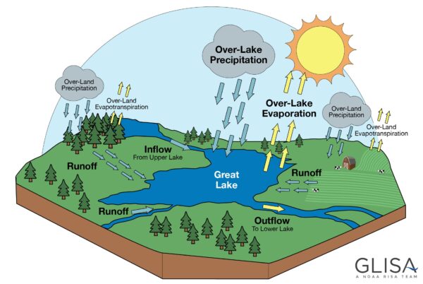
[From University of Michigan]
Then how do we know their age?
I don’t personally know any geologists or hydrologists who date lakes. Even so, while they might enjoy watching a sunset or a moonrise with their significant others, I doubt even the most passionate among them have a romantic in anything lacustrine. Geologists use five primary methods for determining a lake’s age:
- Sediment Core Analysis – Extracting deep sediment cores from lake bottoms, counting sediment layers, and analyzing their composition.
- Radiometric Dating – Applies this technique to volcanic rocks in and around the lake.
- Paleomagnetic Dating – Analyzes the magnetic orientation in sediment layers and matches them to known geomagnetic reversal timelines.
- Tectonic Basin Analysis – how plate tectonics drive the formation, evolution, and filling of sedimentary basins.
- Fossil and Biological Evidence – This involves looking at the evolution of any endemic species.
Hydrologists focus on the water cycle and the flow of the lake. They calculate residence time which is the average time a water molecule spends inside the lake before it evaporates or flows out and couple that with water age-dating. This technique uses environmental tracers and isotopes (like tritium) to determine how long water has been isolated or the age of incoming groundwater.
Number one or two or three and definitely top 20
With its estimated age of 2,300,000 years, it’s fair to call Lake Tahoe the oldest permanent freshwater lake in North America. (Some will opt for the past champion, Clear Lake that has a confirmed continuous age of 480,000 years but there’s been a body of water there for nearly 3,000,000 years. Others will point to Tule Lake but the best evidence indicates that its an intermittent lake.) In fact, if you limit your scope to lakes with ages that have been measured rather than estimated (Lake Zaysan is in the latter group) Tahoe places third globally behind Lakes Baikal and Tanganyika.
In its earliest days, Lake Tahoe formed through a mix of tectonic faulting and volcanism. More recently, glaciation also played a role in shaping the lake. The basin dropped between faults as the Sierra Nevada and Carson Range rose, creating a deep valley that later filled with water; volcanic eruptions then blocked the northern outlet, and glaciers later reshaped parts of the shoreline and surrounding valleys.
Geosciences professor Winnie Kortemeier at Western Nevada College staked Tahoe’s claim as the oldest on the continent based on research she started in 2012. After the USGS geochronology laboratory for radiometric dating provided three distinct dates of lava flows for five rock samples she’d sent, she reached a rather surprising conclusion. When the volcanoes erupted, basaltic lava interacted with lake water and sediments in the lake. The oldest rocks were 2,300,000 years old. This provided evidence that Lake Tahoe existed at the time of those oldest lava flows thus providing its current crown as North America’s oldest.
In the next entry, we’ll look at some of the first people to inhabit this part of the continent. Before that, if you’re wondering, the answer is yes, using Gitche Gumee was intended to evoke Gordon Lightfoot.
-

Olympic Valley in the time before humans (Squaw Valley and Me supplement one)
June 12, 2026 -

Here are the songs from the México City and México City Olympics posts
May 18, 2026 -

Notes on the XIX Olympiad – the quiet protest – (México City and Me addendum three)
May 18, 2026 -

Notes on the XIX Olympiad – Successes, failures, and a Flop – (México City and Me addendum two)
May 15, 2026 -

Notes on the XIX Olympiad – Understanding Carlos and Smith – (México City and Me addendum one)
May 13, 2026