A frosty Yellowstone morning – Part 2
The South Rim hike.
I hope you’ve prepared yourselves because, as promised, this is the section where I’m going to delve into the geology of Yellowstone. But I’ll start with a small artistic diversion. Those of you who have traveled with me since the beginning of the trip and who have long memories might recall that, on my first night at Moraine Lake in Banff National Park, I climbed the Rockpile to take the iconic picture of the lake and the surrounding peaks that probably every other visitor with a camera has taken. Now that I’ve arrived at the Grand Canyon of the Yellowstone, it’s time for another such photograph.
Though born in England, because his parents emigrated to suburban Philadelphia when he was a child, Thomas Moran is considered an American painter and part of the Hudson River School. In 1871, Moran joined the Hayden Geological Survey and spent 40 days exploring the Yellowstone region. His sketches, together with the photos by William Henry Jackson, another member of the Survey team, are said to have played a key role in Congress’ decision to establish the National Park in 1872 – the same year that Moran painted the first of two paintings called The Grand Canyon of the Yellowstone. (Recall that this park was the first of its kind in the world and was initially called by this simple and straightforward designation. The title of Moran’s painting refers to the river.)
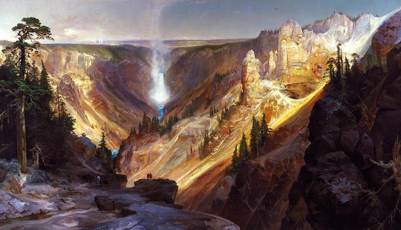
This painting is part of the Permanent Collection of the Smithsonian Museum of American Art and is frequently on display in that august institution fewer than 12 miles from my front door. It’s one I’ve seen often and with which I am quite familiar. Even in 1872, the area from which Moran painted this masterwork had been dubbed Moran Point. I’m reasonably confident that every visitor with a camera has taken a photo from this spot. And I am no exception.
I will point out, though, that Moran took some artistic license in his painting. Look closely at the upper left quadrant and you’ll see three spouting geysers. While there is some thermal activity in the area of the G C o Y and steam vents are sometimes visible along the canyon walls, there are no geysers and, as I hope you can see from the map in the previous post, the geyser basins are too distant for any spouters to have been visible.
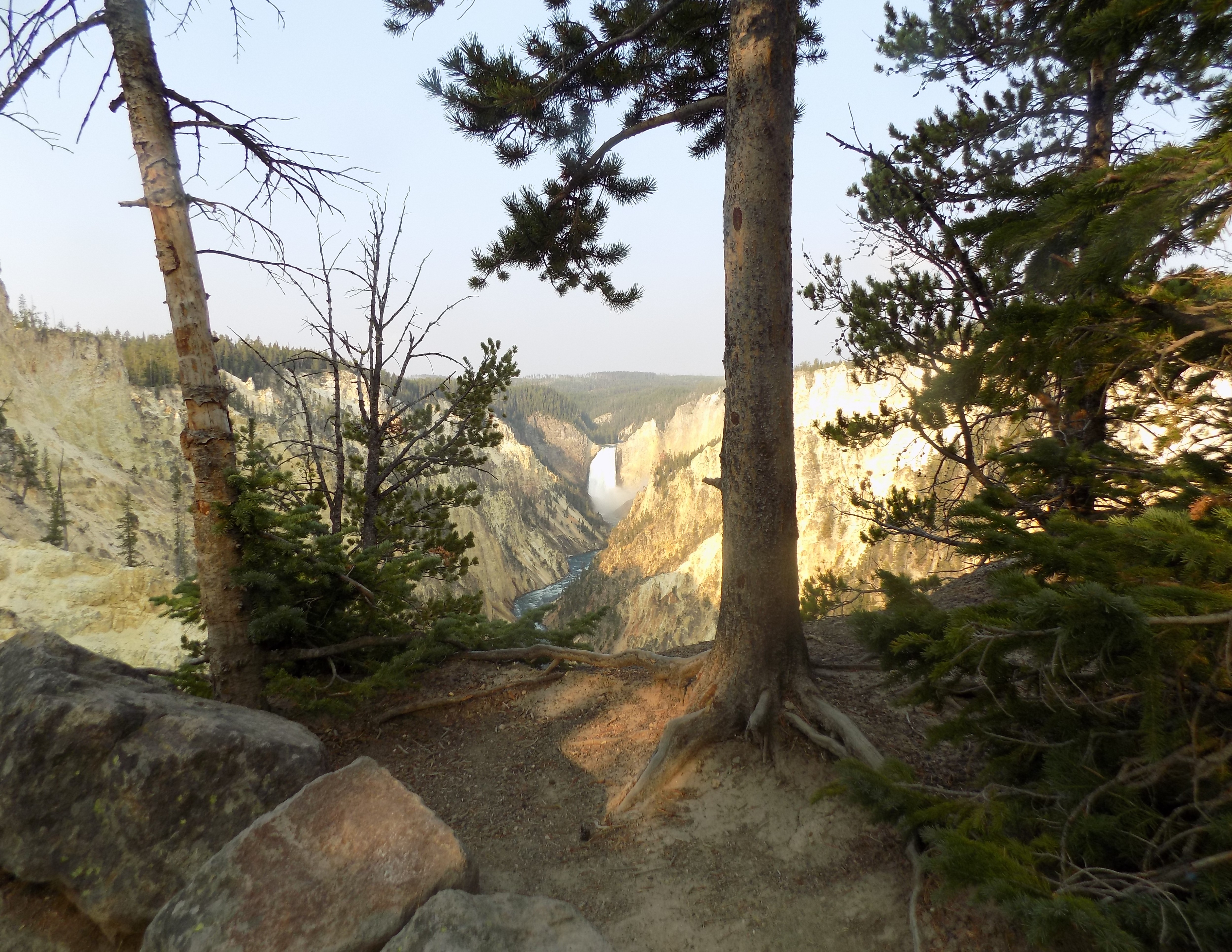
The yellow canyon walls, while heightened by the morning sunlight, in fact, do provide some evidence of thermal activity in and around the canyon. Much of the color is a result of sulfur rising up from below the surface and staining the rocks.
The canyon itself is quite young – a mere 13,000 years old and its depth, that varies from 800 feet to 1,200 feet along its 24 mile length also provides evidence of some of the thermal activity in the area.
(Compare this to the Grand Canyon which has an average depth of about one mile and maximum depth of 6,093 feet. But then consider that it’s taken the Colorado River more than 6,000,000 years to create a canyon of that depth. In other words, the G C o Y has reached about 19 percent of the Grand Canyon’s depth in about two-tenths of one percent of the time.)
The walls of the G C o Y are primarily rhyolite which is an extrusive igneous rock formed from granitic magma that has partially cooled in the subsurface. It’s usually pink or gray in color and is typically comprised of quartz, feldspar, plagioclase, and sanidine. All of these are generally quite hard – between 6.0 and 7.5 on the Mohs scale. Rhyolite usually forms in continental or continent-margin volcanic eruptions where granitic magma reaches the surface and it’s rarely produced at oceanic eruptions.
So, if the rock is so hard, how is it possible for the Yellowstone River to be so much more efficient in cutting through it to form a canyon than the Colorado has been in creating the Grand Canyon just 800 miles to the south? Once again, the answer lies in Yellowstone’s thermal activity.
A geologic step back in history.
According to the park ranger who led the walk, as large as Yellowstone National Park is, it is smaller than the magma chamber that lurks below it. In fact, Yellowstone sits atop not a mere volcano but rather atop a super volcano.
We’ll begin by looking at the difference between a caldera and a crater. In strictly volcanic terms, they are two different kinds of depressions. A caldera is formed when a large eruption of magma, or lava, leaves a gigantic empty chamber underground. The volcanic material above the chamber then collapses in on itself into the empty magma chamber.
A terrestrially formed crater is almost always a vent for volcanic activity. (Recall that craters, as we learned from my visit to the Barringer Meteor Crater in Arizona, can have extra-terrestrial origins as well.) When magma and other material is ejected from a vent, that material can build up over eons to form a mountain. A violent eruption such as the one in 1980 at Mount St. Helens will simply blow the top off the mountain and leave a crater behind.
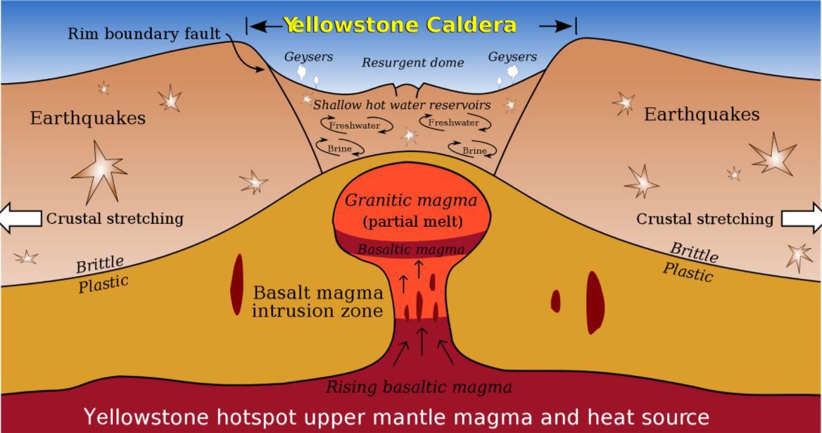
[From Wikipedia BY Kbh3rd – Public Domain.]
As we’ve traveled across the western United States, I’ve subjected you to repeated and lengthy discussions about the widespread mountain-building, volcanism, faulting, and glaciation processes that have shaped the landscape during the Cenozoic era (the last 66 million years of Earth’s history). Believe it or not, it’s time for a little more.
Approximately 30 million years ago, much of today’s West began stretching apart along an east–west axis. The pace of this stretching process increased about 17 million years ago creating the modern basin and range topography (north–south mountain ranges with long north–south valleys) that characterizes vast areas of the West, including Yellowstone. This stretching continues today.
At about the same time geologically speaking, an intense period of volcanism erupted near the intersection of present-day Nevada, Oregon, and Idaho. Geologists can trace repeated volcanic eruptions across southern Idaho towards Yellowstone. This created a 500-mile trail of more than 100 calderas as the North American plate moved in a southwesterly direction over a shallow body of magma. About 2,100,000 years ago, the movement of the North American plate brought the Yellowstone area closer to the shallow magma body. And that’s when we had the first Yellowstone eruption. The second occurred about 1.3 million years ago and the most recent eruption was 640,000 years ago.
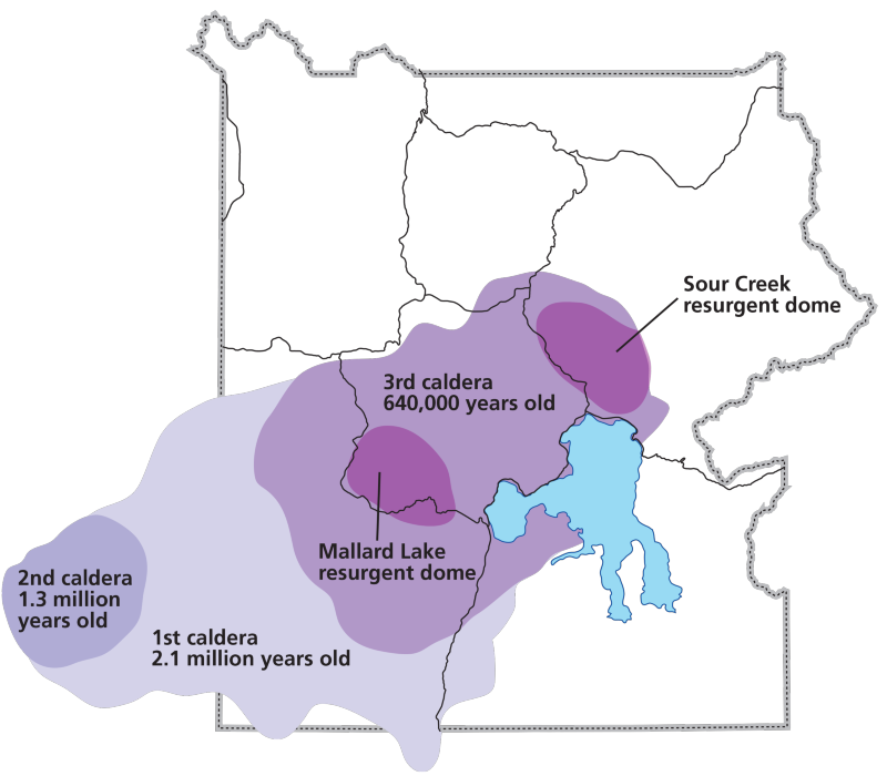
[From NPS Adapted with permission from Windows into the Earth by Robert Smith and Lee J. Siegel, 2000]
Up next, a possibly frightening look at super volcanoes and the reason we need to allow true wildfires in the park to burn.
-

Here are the songs from the México City and México City Olympics posts
May 18, 2026 -

Notes on the XIX Olympiad – the quiet protest – (México City and Me addendum three)
May 18, 2026 -

Notes on the XIX Olympiad – Successes, failures, and a Flop – (México City and Me addendum two)
May 15, 2026 -

Notes on the XIX Olympiad – Understanding Carlos and Smith – (México City and Me addendum one)
May 13, 2026 -

Y no te puedo hallar
May 11, 2026