A Frosty Yellowstone Morning
If I thought it had gotten chilly overnight when I was in Jackson, when I woke up Tuesday morning, it was as though Yellowstone was telling me, “Those wimps down in Jackson don’t know what cold means.” The windows on my car were so covered with frost that if I’d had a scraper, I’d have used it. You might remember that I’d picked up my hitchhikers because we were all going to the area called Canyon Village which is close to the Grand Canyon of the Yellowstone (G C o Y). When I finally got the windshields clean, I pulled out onto the Grand Loop Road and saw this:
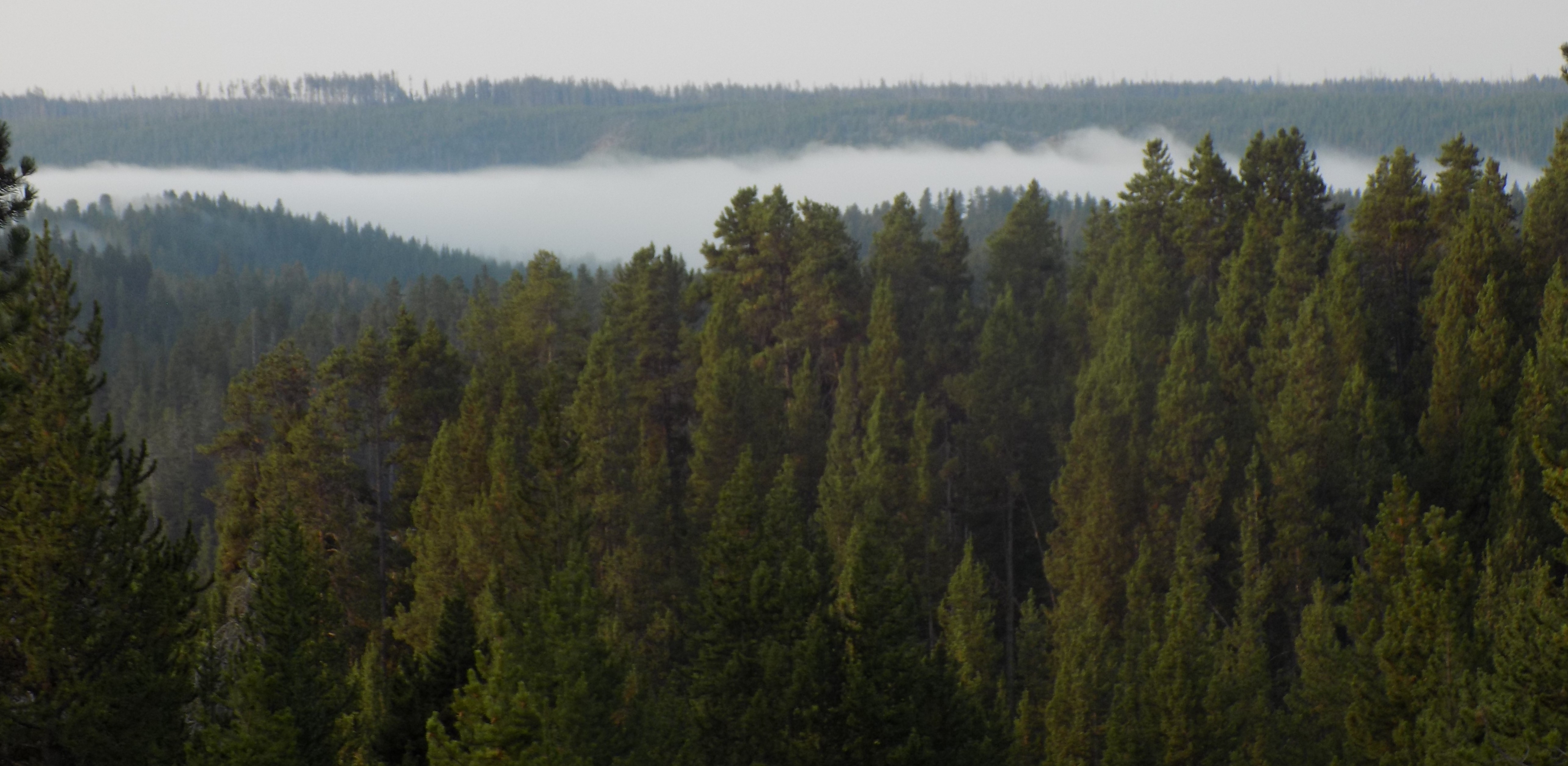
This time, it isn’t ash. It’s a cloud of mist rising from the very river that had cut the canyon.
I’d planned an early start because I had a full and extensive day planned starting with a drive along the North Rim Road and hiking to the brink of the Upper Falls with its 109 foot cascade. Then, time and (now) chill permitting, I’d hike to the Lower Falls which drop 308 feet or 140 feet more than Niagara Falls though its cataract is much narrower and its volume much less than its famous eastern cousin. After viewing the pair of falls, I expected to join a ranger led walk along the South Rim Trail before heading out to explore some of the different aspects of the park.
Once the canyon walk ended, I planned to drive back to the geyser basins because I wanted to see the Grand Prismatic Spring while perhaps coincidentally spotting some of the other geysers as they gushed. From there, I’d loop back north toward Mammoth Hot Springs, then east toward Tower Roosevelt and late in the day to the Lamar Valley in the hope that the wildlife for which that area of the park is so famous would be out and about. The route looked something like the one on this map.
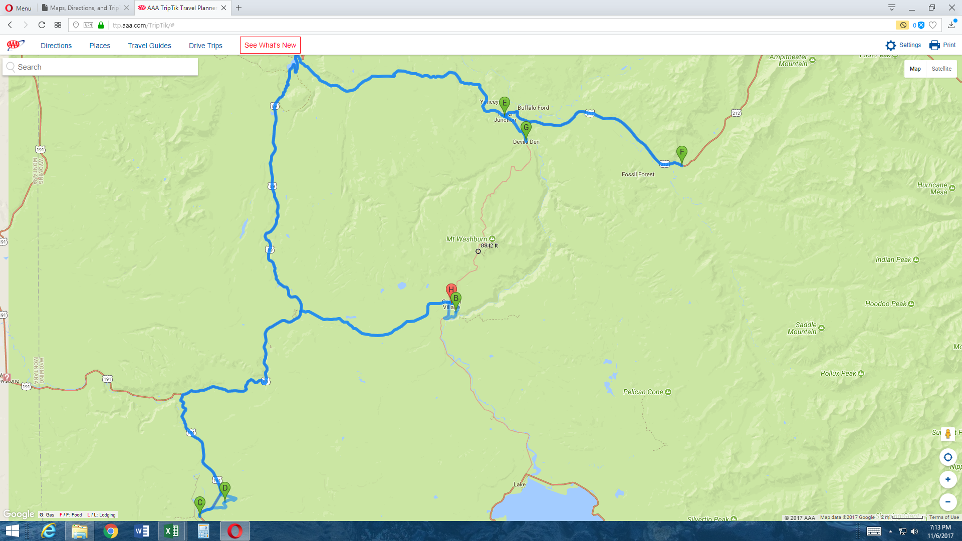 From the Lamar Valley, I’d return to Canyon Village via the Grand Loop Road past Mount Washburn – which at 10,223 feet is the highest peak in the Washburn range that dominates that part of the park. (The highest point in the park is Eagle Peak which is 11,372 feet at the summit and is about 7 miles east of the southeast arm of Yellowstone Lake.)
In all, I’ll drive about 200 miles today without ever leaving the park. It’s going to be a long day so settle in and let’s see how much of my ambitious plan I accomplished and how much I missed.
First stop – the Upper Falls of the Yellowstone River.
Some American visitors to Yellowstone National Park become confused when they see that the Lower Falls of the Yellowstone River are north of the Upper Falls. I think this is mainly because Americans have a predominantly North to South bias in our world view (and I include myself in that number). Our maps are drawn with north at the top and south at the bottom. Since this is also the way we read it’s the direction our eyes move and this reinforces the notion that north is up and south is down.
The first successful European settlements were in New England and worked their way south. The north was the triumphant side in the American Civil War. And the country’s predominant river, the Mississippi, flows north to south. Thus, we can become a bit disoriented when confronted with a river like the Yellowstone that flows from south to north. But this is, indeed, the direction it flows so the Upper Falls are south of the Lower Falls.
The headwaters of the Yellowstone River, which gives its name to the park, rise at Younts Peak in the Bridger-Teton National Forest east of the park. The river flows for 692 uninterrupted miles before its confluence with the Missouri River in North Dakota making it the longest free flowing river in the lower 48 states. Interestingly, in terms of volume, the Yellowstone is not only the largest tributary of the Missouri but, at their confluence is the larger of the two rivers.
The origin of the name Yellowstone is uncertain and two possible explanations have been put forward. The Apsaalooke or Crow Indians, whose presence in the area antedated the Europeans by millennia, called the river (and pardon my poor transliteration) iichiidikara’ashe or Elk River and one explanation is that there’s enough similarity between the Crow words for yellow (shiile) and elk that French fur traders simply misheard and began calling the river Roche Jaune or Yellow Rock.
(In my three posts about some of the treaties signed and broken, {the link will take you to the first of those} that led to the battle at Greasy Grass, I noted that the use of the Bozeman Trail was a contributing factor in Red Cloud’s War and then the 1868 Treaty of Laramie. Settler intrusion into these traditional Apsaalooke hunting grounds and the establishment of trading posts along the river was another factor that led to that war and treaty.)
The second explanation ascribes the name to a different tribal branch of the Hidatsa, the Minnetaree, who lived near the confluence of the Yellowstone and the Missouri. Their name for the river, Mitsedazi, indeed translates as Yellow Rocks and was possibly drawn from the yellow sandstone bluffs along the lower river. The Lewis and Clark Expedition encountered them in 1805 and recorded the river’s name as Yellow-Stone.
One of the first stops on the North Rim Road is at the trailhead to the Upper Falls. This is a short but modestly steep trail with a 75-foot change in elevation over just a few hundred yards but I found the view so exhilarating that it made the hike up seem quite easy. While you might enjoy the photo,
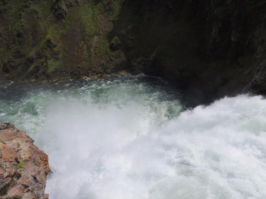
I think my video is a bit more interesting. (I decided to pass on the hike down to the brink of the lower falls because the trail, though relatively short at 3/8 of a mile is very steep with a 300 foot change in elevation and I thought the round trip would take so long that I might reach the South Rim too late for the ranger guided walk.)
We’ll start that walk and have a lesson in geology in the next post.
Note: In keeping with my 2022-2023 reformation of the blog into shorter entries, backdated to maintain their sequence, any comments on this post might pertain to its new configuration. See the full explanation in the post Conventions and Conversions.
-

Here are the songs from the México City and México City Olympics posts
May 18, 2026 -

Notes on the XIX Olympiad – the quiet protest – (México City and Me addendum three)
May 18, 2026 -

Notes on the XIX Olympiad – Successes, failures, and a Flop – (México City and Me addendum two)
May 15, 2026 -

Notes on the XIX Olympiad – Understanding Carlos and Smith – (México City and Me addendum one)
May 13, 2026 -

Y no te puedo hallar
May 11, 2026
3 responses to “A Frosty Yellowstone Morning”
Looks like Mars and Karelia in one. Impressive.
Hope the vulcano is not going to wake up !
I’ll take your word for that, I’ve never been to Mars or Karelia.
Really interesting post!