Lake Placid in the time before humans (Lake Placid and Me – supplement one)
The Appalachian Mountains are almost unfathomably ancient – at least a part of the chain is. That part would be the range called the Blue Ridge Mountains that begins in southern Pennsylvania near the spot marked South Mountain on the map below and stretch through much of western North Carolina into the Great Smoky subrange. Although the full range of the Appalachian chain is much younger – with an average age closer to 480,000,000 years – some of the Precambrian gneisses and granitoids in the core rocks of the Blue Ridge date to the Grenville Orogeny some 1,250,000,000 years ago and this is the time when these mountains arose.
Look closely at the map and you can spot an oddly shaped bubble that the legend lists as Adirondacks. They’re shown separately for good reason. While nearly all of the rocks found in the Adirondacks date from the Grenville orogeny, the processes that gave rise to these particular mountains happened quite differently and much more recently (geologically speaking) than their neighbors to the east. In fact, they are sometimes described as young mountains of old rocks.
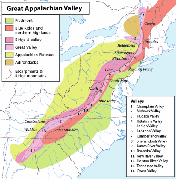
[From Wikipedia By Greatvalley-map Pflyderivative work CC BY-SA 2.5]
Most of Earth’s mountains rose from orogenic processes and most orogenic processes result from plate tectonics. These include subduction zones, continental plate collisions, and the accretion of terranes and other crustal fragments driven by tectonic plate movement. (Subduction is a geological process that takes place at convergent boundaries of tectonic plates where one plate moves under another and is either forced down or sinks due to gravity into the mantle. Regions where this process occurs are known as subduction zones.) This is not what happened to form the Adirondacks. Although they were affected by some of the same continental collisions that uplifted the Appalachian Mountains, they aren’t geologically related to them.
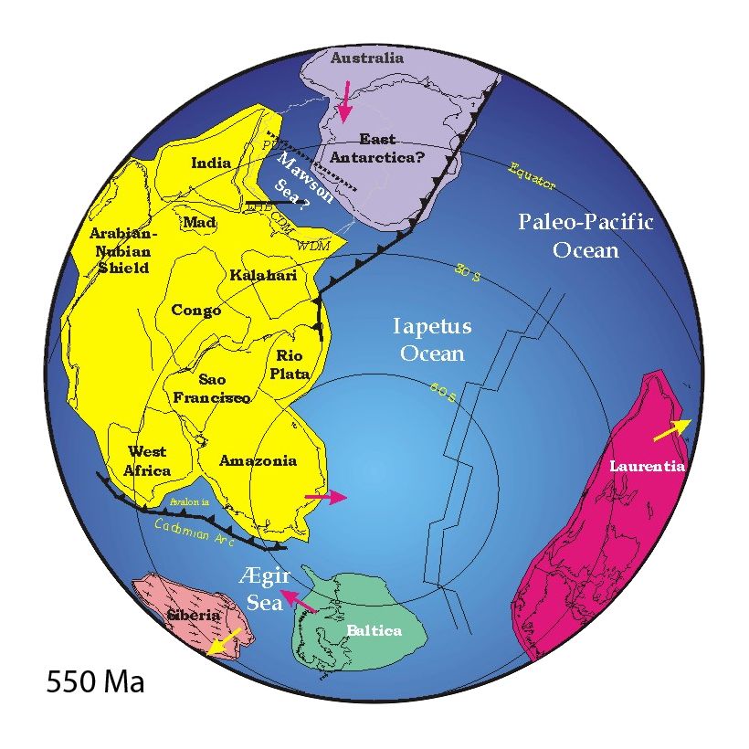
We could fire up the WABAC machine and watch a series of orogenies beginning with the Grenville Orogeny a billion years ago that uplifted mountains that certainly rivaled the elevations of the Andes and possibly the Himalayas. Over the ensuing 400 million years, we could watch these mountains and plateaus – now part of the supercontinent Pannotia – erode to flat lands when Pannotia

[From Wikipedia – Public Domain]
began breaking apart, gradually producing continental blocks such as Laurentia, Baltica, Amazonia, and Río de la Plata, and the Iapetus Ocean.
About 550 million years ago, a long volcanic island arc formed in the Iapetus Ocean. It then collided with what was later to become North America. However, it took another 00-300 million years before the continental blocks of Pannotia began colliding to form the supercontinent Pangaea. These collisions generated the Alleghenian Orogeny and built the Appalachian Mountains.
[From Britannica.com]
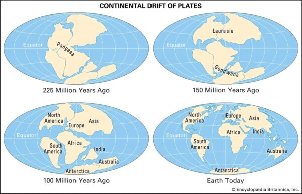
(Over the next 100-150 million years, Gondwana would break off from Pangaea and then these two supercontinents would break apart to shape the Earth we inhabit today.)
The formation of the Adirondacks is a geologic puzzle because they lie entirely within one mostly stable tectonic plate. These types of mountains are called intracratonic mountains and the mechanisms that create them aren’t well understood.
Using data from an advanced seismic imaging method measuring the speed of seismic waves traveling through the Earth available only since 2010, UMass Amherst postdoctoral fellow Xiaotao Yang and UMass Amherst assistant professor Haiying Gao, constructed a detailed model of the North American Plate down to about 62 miles in which they discovered what they termed a “pillow” of low-density, relatively light rock material. They say a column of this lighter material appears to have squeezed up under the Adirondacks, possibly expanded by heat, to form the dome-shaped mountains.
They hypothesize that between 90 and 120 million years ago, the North American Plate passed over a geologic “hot spot. As we learned from looking at the formation of the Hawaiian Islands, hot spots remain stationary and, over the course of time can accrete layer upon layer until a new land mass forms. But this particular hot spot is now under the western Atlantic Ocean, in the New England seamounts. And yet, somehow, the hot spot activities may have contributed both active and residual heat to the processes forming the Adirondack Mountains.
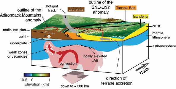
[From AGU]
Additionally, it could have been the movement of this lighter, buoyant material into a fracture or vacant space within the asthenosphere (a mechanically weak, ductile region of the Earth’s upper mantle located just below the lithosphere) with an onset of about 20 million years ago to begin pushing up a dome about 150 miles across. Erosion caused the system of parallel valleys seen in the first map above while simultaneously exposing the billion years old rocks.
But we’re not quite done with the region’s oddities.
A second quite recent series of events began shaping the Adirondack landscape during the Pleistocene Epoch that began 2,600,000 MYA. This period represents Earth’s most recent period of repeated glaciations and scientists from the International Commission on Stratigraphy have identified four ages within the Pleistocene: the Gelasian (2,6oo,ooo to 1,800,000 years ago,) Calabrian (1,800,000 to 781,000 years ago), the Chibanian (781,000 to 126,000 years ago, and the late Pleistocene (126,000 to 11,700 years ago).
Cooling and warming climates around the world led to the repeated advance and retreat of huge ice sheets globally but more intensively in the northern hemisphere. The Wisconsin glaciation represents the last advance of these massive ice sheets and in places buried the land under nearly two miles of ice deforming the land.
Beginning between 80,000 and 100,000 years ago, the Wisconsin glaciation reached its last global maximum. Its retreat began around 20,000 years ago.
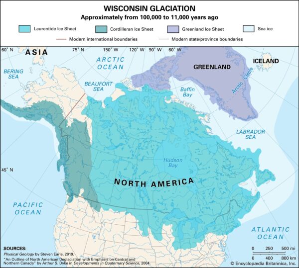
[From Britannica.com]
Glaciers carve landscapes as they advance and retreat. In coastal areas this advance and retreat creates fjords. Inland, it creates valleys by scraping away soil and loose sediment, wearing down bedrock, and depositing rock debris.
Also, as temperatures warmed and the ice sheets began a northward retreat known as the Wisconsin deglaciation, it created more than 3,000 lakes and ponds in the Adirondacks alone. The melting ice sheet released huge volumes of meltwater. Meltwater lakes formed in places where glacial debris had dammed valleys. Further, in the case of the Adirondacks, the retreating glacier rounded off the mountain peaks.
The last of our Adirondack oddities is that the mountains continue rising at an estimated rate of about a foot per century or nearly 50 percent faster than the Himalayas. The process of isostatic rebound – in which, freed from the burden of bearing the glacial weight, the land begins a slow process of reformation – may be a contributing factor. The other is likely the continued expansion of the “pillow” of expanding light rock.
If you find this interesting, you should stay tuned as more information becomes available and hypotheses are confirmed or disproven. But I’m not a geologist so it’s time to move on to see how some of the earliest Americans lived after populating the area.
-

Here are the songs from the México City and México City Olympics posts
May 18, 2026 -

Notes on the XIX Olympiad – the quiet protest – (México City and Me addendum three)
May 18, 2026 -

Notes on the XIX Olympiad – Successes, failures, and a Flop – (México City and Me addendum two)
May 15, 2026 -

Notes on the XIX Olympiad – Understanding Carlos and Smith – (México City and Me addendum one)
May 13, 2026 -

Y no te puedo hallar
May 11, 2026