
Melbourne in the time before humans (Melbourne and Me supplement one)
Ask a geologist to name two qualities that characterize the Australian land mass and the most likely answer will mention its antiquity and its stability. For example, the Pilbara Craton, in northwestern Australia, is one of the Earth’s oldest with rocks older than 3,600,000,000 years and, in southwestern Australia, the Yilgarn Craton contains low-grade granite-greenstone rocks with ages between 3,730,000,000 and 2,550,000,000 years.
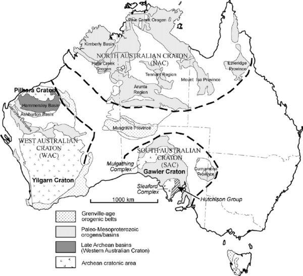
[From Research Gate uploaded by Elizabeth Ann Jagodinski]
The continent sits atop the Australian plate and, while the plate is moving at the relatively rapid rate of seven centimeters per year, Australia itself is so far from the plate’s tectonic boundaries that it’s mainly only along for the ride.
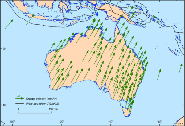
[From Digital NSW]
This geologic stability has been evident since at least the breakup of Gondwana some 300 MYA.
But there’s one in every family
The rebel. The non-conformist. For Australia, that would be the east coast. If you look at the first map above, ancient stable cratons are notably absent from the eastern third of the continent. However, one feature that is prominent on the eastern side of Australia is volcanoes.
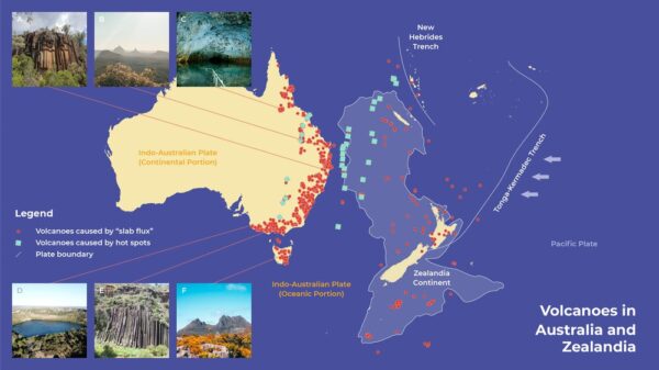
[From Phys.org]
But curiously, they’re volcanoes that shouldn’t be there. Until recently, geologists understood two mechanisms that created Earth’s volcanoes. We’ve encountered the most common of these in this blog’s discussion of the Pacific Ring of Fire. These volcanoes begin with the process of subduction when parts of the seafloor at a tectonic plate boundary get shoved into the Earth’s mantle. And it’s hot down there – hot enough for the seafloor to melt and then rise – as hot things like to do. Eventually, the hot stuff has to go somewhere and it erupts as a volcano.
Volcanoes can also form when stationary mantle plumes track the movement of tectonic plates. These so called “hotspot chains” are essentially the process that gave rise to the Hawaiian Islands. But, as we’ve seen, Australia is a long way from its plate boundary and nowhere near any hotspot chains. So what gives? How did these volcanoes form?
A whole new world
The apparent mechanism for forming these volcanoes involves water and carbon dioxide trapped in the seafloor that’s recycled down to the mantle. It then forms a reservoir and lies there quietly until it’s disturbed. Although it’s about 3,000km distant, there’s a subduction zone called the Tonga-Kermadec Trench
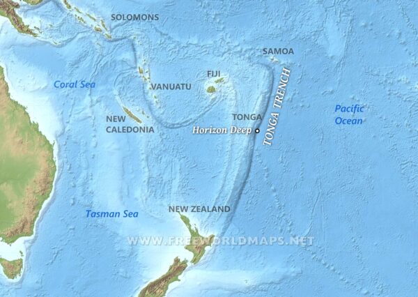
[From Free World Maps]
that’s close enough to agitate the reservoir resting 410km below the surface. When subduction occurs in this spot, the vibrations reach the mantle reservoir beneath eastern Australia causing the water and C O2 to rise up and produce volcanic eruptions at the surface.
Fortunately for the humans in the area – both the Aboriginal People who arrived some 40,ooo years to 60,000 years ago and the Europeans who arrived about 300 years ago, the most active period of this volcanism ended about 2,000,000 years ago. That’s not to say that we can sound the all-clear bell. Most of these volcanoes are dormant rather than extinct even if the most recent known eruption on the mainland happened at Mount Gambier in South Australia some 5,000 years ago.
To go way back, we need the WABAC
Truth be told, I’m not programming the WABAC to take us nearly as far back as I could. I’m only going to ask the machine to take us back to the Gondwanda breakup that you might have read about in the post Sydney in the time before humans. In fact, all I’m going to say about that is that you should remember that as Gondwana began breaking apart into the continents that support life today, Australia and Antarctica were a bit like a pair of conjoined twins. They stayed together for a mere 80 to 90 million years (geologically speaking) at which point Australia began its persistent northward march. And once it gained a little independence, Australia began racing northward.
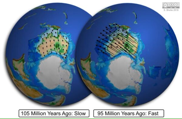
[From University of Sydney by Sascha Brune]
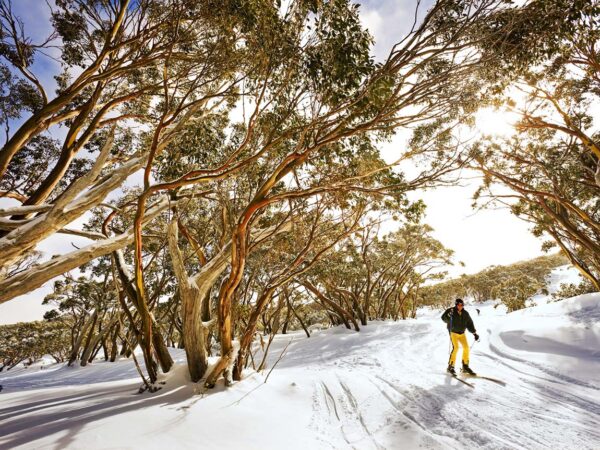
As Australia and Antarctica were breaking apart, the Tasman Sea began to open by seafloor spreading. This caused rifting along the eastern margin of Australia which, in turn, generated tension in the Earth’s crust. The tension caused by the rifting allowed hot mantle material to rise closer to the surface resulting in thermal expansion of the crust and subsequent uplift. The process of isostatic rebound uplifted the western edge of the rift basin. This then formed the Eastern Highlands and now Aussies can ski down mountains like Mount Baw Baw.
[From Visit Victoria]
Sedimentary not sedentary
While we’re in the WABAC hovering above the Eastern Highlands as they grow up, we can to look to our west to see the Murray Basin taking shape. Many of the rivers that flow into the Murray Basin begin in the highlands of the Great Dividing Range rushing down toward the flat plains of the basin where their flow slows considerably. The Murray is exceptionally important because it’s called Australia’s food bowl.
However, as fascinating as that might be, because our focus is Melbourne, we need to turn our attention to the east and the Yarra, Bunyip, and Thomson basins. The presence of Tertiary sediments and volcanic activity in the region indicates the time frame for their formation.
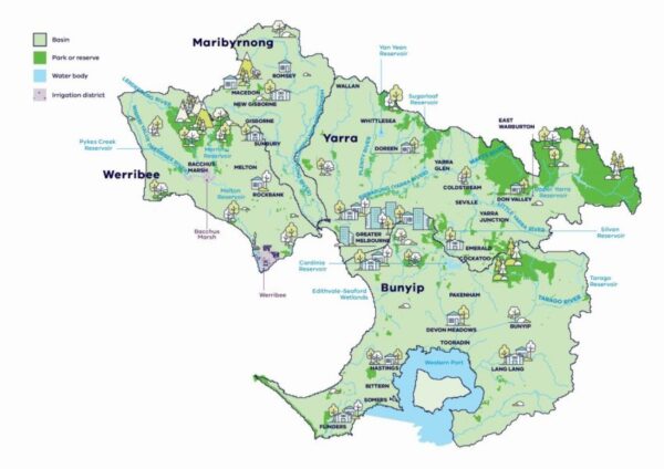
[From Victoria Water]
Volcanism was the key element in the formation of the Yarra Basin. Both Older Volcanic Series (Tertiary) and Newer Volcanic basalts (Pliocene to Recent) played a role in shaping the landscape. Old basalt quarries provide evidence for four distinct lava flow events that are visible through breaks in the basalt, changes in cracking patterns, and variations in vesicular (bubble) patterning. These eruptions occurred between 4,500,000 and 800,000 years ago. Volcanism altered drainage patterns, created new landforms, and influenced the course of the river itself.
On the other hand, the Bunyip River valley shows evidence of complex depositional terrain and alluvial fans, suggesting a long history of formation. As it emerged in its southeasterly flow from the ranges to the north, the river was (and remains) flanked by alluvial fans and terrace deposits reflecting the deposition of sediments as the river’s flow slowed upon reaching flatter terrain. The presence of higher level terraces and flood plains indicates the gradual deposition of sediments and multiple stages of development over time.
The southeastern section of Australia remains geologically active. The basins continue evolving through ongoing geological and hydrological processes, including sedimentation, erosion, and tectonic activity. Recent research suggests that mountain building processes have continued for the past 3,500,000 years and are ongoing in the present day. Frequent, small earthquakes observed along southeast Australia provide further evidence of continued tectonic activity in the region and Victoria’s Eastern Highlands are growing at a steady rate of 76 meters every million years.
Compared to the staid western two-thirds, this area is clearly Australia’s geological subversive.
-

Here are the songs from the México City and México City Olympics posts
May 18, 2026 -

Notes on the XIX Olympiad – the quiet protest – (México City and Me addendum three)
May 18, 2026 -

Notes on the XIX Olympiad – Successes, failures, and a Flop – (México City and Me addendum two)
May 15, 2026 -

Notes on the XIX Olympiad – Understanding Carlos and Smith – (México City and Me addendum one)
May 13, 2026 -

Y no te puedo hallar
May 11, 2026