Fennoscandia in the time before humans (Nordic cities and Me supplement one)
Fenno-where-ia?
If your memory is acute and you were paying very close attention while reading the post Moscow in the time before humans, you might recognize Fennoscandia as one of the three crustal segments comprising the East European Craton also known as Baltica. Since Norway, Sweden, and Finland all lie atop the Fennoscandian (or Baltic) Shield I’m going to provide a cursory look at this segment but, since I’ve previously discussed it, most of this post will look at the formation of three of the prominent geographic features of the area namely the Norwegian fjords, the Scandinavian Mountains, and the Baltic Sea.
Baltica in Brief.
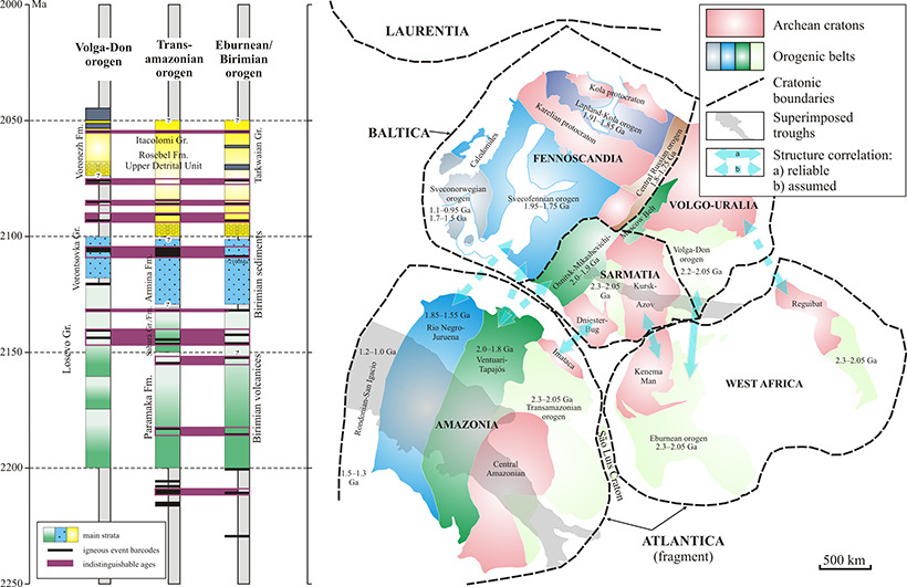
[Map from ScienceDirect].
When I first wrote about Baltica (remember I like Baltica better than East European Craton) my focus was on the area called Volgo-Uralia because that’s where we would find Moscow. With this entry, I’m shifting a little to the west to focus on Fennoscandia. In terms of age and composition Fennoscandia is dominantly Archean in the northeast, but Proterozoic in the southwest.
(Archean refers to the second of Earth’s four principal geologic eons and spans the period from about four billion years ago to 2,500,000,000 years ago. Proterozoic is the third eon spanning the time interval from 2,500 to 541 million years ago.)
While the crustal rock that deeply underlies Volgo-Uralia is also Archean, its upper layers are far more sedimentary than those in Fennoscandia where the rocks are generally accretionary. (In geology, accretion is the process by which material is added to a tectonic plate at a subduction zone. It’s found most frequently on the edge of existing continental landmasses. The added material may be oceanic crusts, seamounts, sediment, volcanic arcs, or other igneous features.)
Looking toward Fennoscandia’s southeast, we discover a continuation of the crust in the Shield that can be traced to a Proterozoic system of paleorifts in the East European platform.(Rifting is defined as the splitting apart of a single tectonic plate into two or more tectonic plates separated by divergent plate boundaries.) These rifts produced the crustal boundary that separates Fennoscandia from Baltica’s other two segments.
Form the mountains.
Normally, when the discussion turns to mountain building the expected baseline is the description of one or more sequences of orogeny. While the Caledonian orogeny, which was confined mainly to a series of tectonically related events was recorded in the northern parts of the British Isles, Svalbard, eastern Greenland and parts of north-central Europe, and the Grenvillian orogeny, which we’ve encountered in both Montreal and Atlanta, contributed to shaping much of the landscape of northern Europe, the Scandinavian Mountain Range appears to have attained most of its height from tectonic processes different from this type of orogeny.

[Photo from Soundcloud.com – to listen, click here.]
The collision between Baltica and Laurentia a bit more than 400 million years ago represents the Scandian phase of the Caledonian orogeny and contributed to the building of this mountain chain but currently the best evidence leads geologists to believe the Scandinavian Mountains reached their present height by tectonic processes different from the standard orogenic model.
Unlike orogenic mountains, no widely accepted geophysical model exists to explain elevated passive continental margins such as the Scandinavian Mountains. Various mechanisms of uplift have been proposed over the years. A study in 2012 put forth the hypothesis that the Scandinavian Mountains and similar elevated passive continental margins most likely share the same mechanism of uplift and that this mechanism is related to far-field stresses in Earth’s lithosphere. The Scandinavian Mountains can, according to this view, be likened to a giant anticlinal (consisting of rocks that compressed into a dome like shape rather than cracking) lithospheric fold (a process arising from the a head on collision of two plates).
In south Norway, where we find Lillehammer, the Scandinavian Mountains had their main uplift phase relatively recently – within the last 23 million years. Thus they are considerably younger than the part of the chain that covers northern Scandinavia which had its main uplift in the Paleogene era beginning some 66 million years ago.
The fjord ranger and the assembly line.
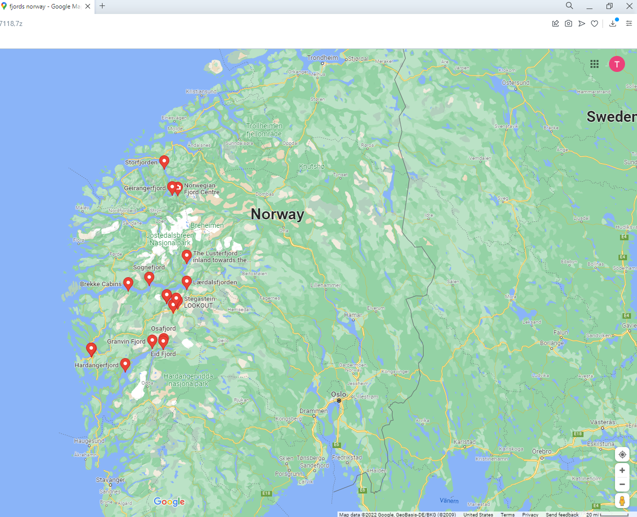
[From Google maps].
Here’s an astonishing fact that turned up on Google during my research about Norway’s fjord system:
Norway’s coastline is estimated to be 29,000 km (18,000 mi) long with its nearly 1,200 fjords, but only 2,500 km (1,600 mi) long excluding the fjords.
Given that the fjords comprise nearly 92 percent of its coastline, it seems safe to say that they are among the defining features of Norway. The map above resulted from simply entering Norway’s fjords as a Google search term and choosing maps as a delimiter. But this map misses at least one fjord – the Drammensfjorden just west of Oslo. Maps will usually label the inlet from the North Sea to Oslo as the Outer and Inner Oslofjord but this body isn’t a geological fjord.
If you recall from the geological supplement in the Moscow chapters, you might remember that an ice age is defined as a succession of alternating glaciations and interglaciations spanning at least one million years and that we are currently living in the interglacial period of an ice age.
Glaciers come:.
Fjords are carved by the advance and retreat of glaciers and the glaciers that carved Norway’s fjords have been doing this dance for two-and-a-half million years or so. While it’s not representative of the maximum glaciation of the Neogene epoch, the Don Glaciation dates 800,000 years into the past and lasted for approximately 200,000 years.
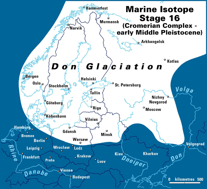
[Glacier map from qpg.geog_.cam_.ac_.uk].
As they advance, glaciers pick up debris and rocks that they slowly take with them. Coupled with the sheer weight of the ice, glacial advance and retreat carves deep U-shaped valleys in the land. This is how a fjord begins.
And glaciers go:.
The earth’s geothermal processes such as volcanism eventually warm the environment and the glaciers begin to melt and retreat. Areas where the glaciers covered not only the land masses but extended into the ocean are conducive to creating a fjord. In those places where the glacially carved valley dips below sea level, the sea fills the void as the glacier retreats and, although the process is achingly slow – about 1.02 mm per year – when it’s done you have a fjord like Geirangerfjord which I sailed through in 2015.

Baltic – a Sea.
On the night of 29 July 2015, I boarded this ferry
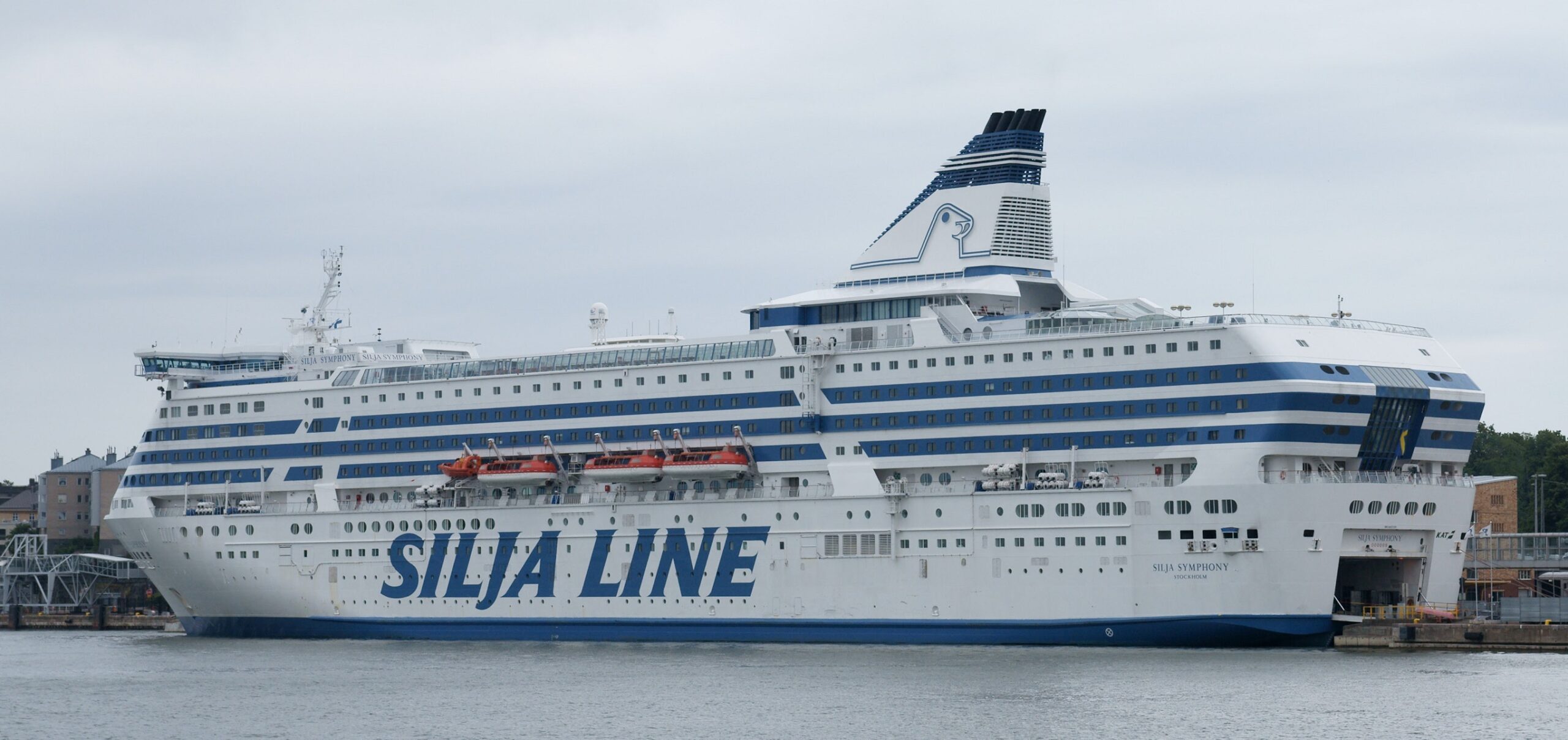
and sailed across part of the Baltic Sea into its eastern arm called the Gulf of Finland. My journey stopped at Helsinki. Had I or the ship continued to the east we would have eventually reached Saint Petersburg, Russia. This sea played a crucial role in the economic, social and cultural development of the nations that border it but this section will briefly examine how the sea itself came to be.
One could fairly describe the Baltic Sea as a young body of water. As the Pleistocene Epoch glaciations ended, the Scandinavian ice sheet that had once covered northern Europe as far south as the present German-Polish coastline, diminished in a retrogression toward the Arctic. In this instance, a combination of more melting than erosion and the fact that the land had remained closer to sea level, the process – that looked like this – yielded what became the largest body of brackish water in the world.
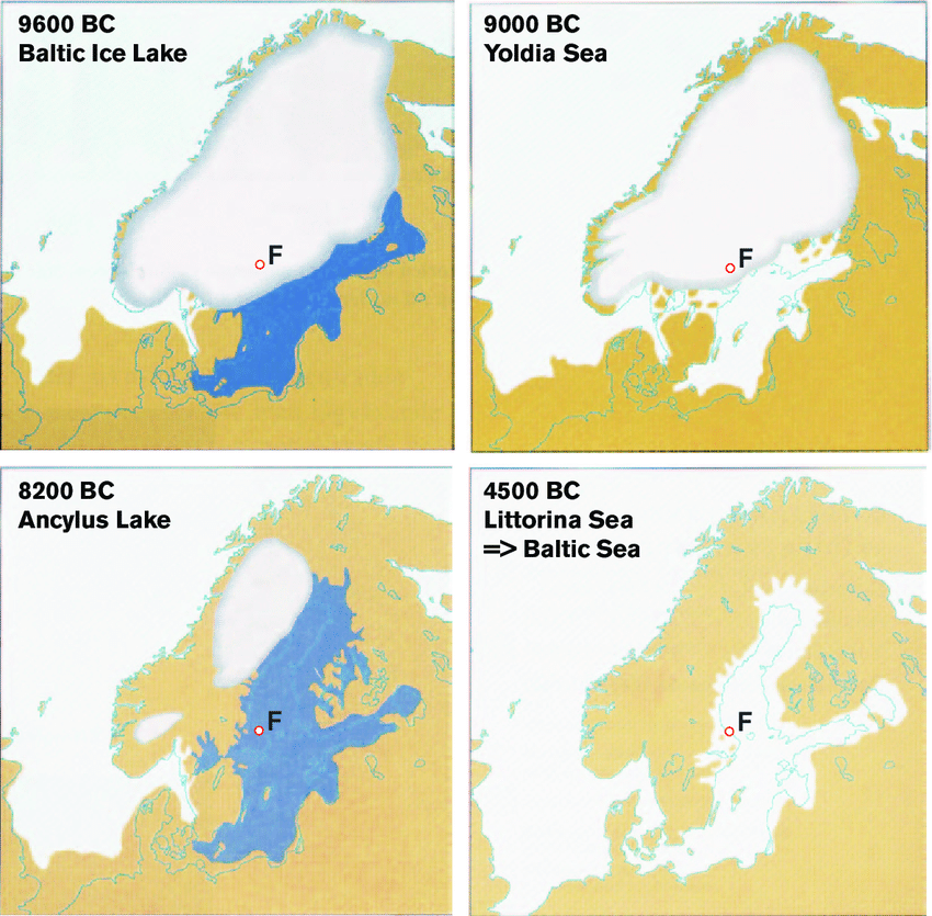
[Maps from researchgate.]
A look at the maps above provides a partial explanation for the low levels of salinity in the Baltic. The bottom maps show that today’s Baltic was a freshwater lake as recently as 8,400 years BP and that sometime in the period between 8200 BCE and 4500 BCE the North Sea breached the land separating it from Ancylus Lake.
Today, a combination of factors work to depress the salinity of the Baltic Sea. The principal reason is that it is nearly landlocked. Its main outlet, the Øresund, is both shallow and narrow. Of course rivers make their own freshwater contributions and the Vistula and the Oder, the two longest rivers feeding the Baltic, drain regions that have a temperate continental climate with low evaporation rates and high levels of spring snowmelt that keeps the water salt free.
Because of its proximity to the North Sea which has a typical oceanic salinity of 35 grams per liter of water, the highest salinity is found in the western Baltic but even its salinity is limited – 10 grams per liter at the surface and about 15 parts per thousand near the bottom.
Now that we’ve had a look at some of the region’s major geographic features, the next post can explore the first Nordic people.
-

Here are the songs from the México City and México City Olympics posts
May 18, 2026 -

Notes on the XIX Olympiad – the quiet protest – (México City and Me addendum three)
May 18, 2026 -

Notes on the XIX Olympiad – Successes, failures, and a Flop – (México City and Me addendum two)
May 15, 2026 -

Notes on the XIX Olympiad – Understanding Carlos and Smith – (México City and Me addendum one)
May 13, 2026 -

Y no te puedo hallar
May 11, 2026