Moscow in the time before humans (Moscow and Me supplement one)
It’s not a Monopoly property, it’s a paleocontinent.
If you’ve managed to slog through my posts on geology, or more specifically paleogeology, the names of some ancient supercontinents should be at least passingly familiar. Pangaea, Gondwana, Rodinia, or Laurentia should generate some recognition even if you can’t place any of them temporally or geographically. Now it’s time to introduce the latest paleocontinent to add to the list: Say hello to Baltica. I don’t plan to take another deep dive into tectonics and plate movement but be forewarned that Baltica likely won’t be the only new name you encounter on this WABAC ride.
In addition to a long setup for a pun, one reason for my fascination with Earth’s dynamic geology is that it helps me maintain a certain perspective. That which can be catastrophic on a human scale and timeframe is insignificant globally and geologically. For example, during my research on East Asia and the plates of China I learned that India is moving toward the northwest at an average rate of five centimeters per year. This means that if I live 100 years India will have moved about five meters or a distance I can cover in fewer than seven steps and yet the energy is so great and the time scale so long that it is part of the Himalayan orogeny. As Vizzini repeats, “Inconceivable!”
In geology there may not be Cartons but there are Cratons.
Craton is a term that has popped up here and there throughout this blog but for those who don’t recall,
a craton is the old and stable part of a continent’s lithosphere. Earth’s two topmost layers, the crust and the uppermost solid mantle comprise the lithosphere. If you’re more visual than verbal, Earth’s layers look like this:.
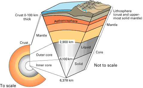
[Image from USGS.]
Because I like the word, I will generally refer to Baltica when discussing the craton that comprises the old, cold, and thick lithosphere underlying nearly all of northeastern Europe. However, it’s currently more commonly called the East European Craton (E E C) and while Baltica may be considered quaint, it’s more or less interchangeable with E E C.
It makes sense that as we look further into the past details become fuzzier and this is the case with Baltica. The evidence for our planet’s oldest supercontinent dates back between 2 point 1 and 1 point 8 G a (G a = billion years) and it’s sometimes called Columbia and sometimes Nuna. Again, the terms are interchangeable. On this, there’s general agreement but take one step beyond and you can find more than a dozen models for this Paleoproterozoic supercontinent. (The Proterozoic spans the period from 2 point 5 G a to 541 M a.) For our look at Baltica, I’ve chosen to use a model proposing three crustal segments called Fennoscandia, Sarmatia, and Volgo-Uralia (and if you don’t like my choice there are others you can research on your own). Each segment has a specific crustal architecture and evolution and they are separated by the major Volga-Don and Central Russian Paleoproterozoic collisional belts.
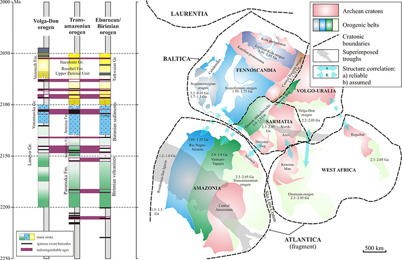
[Map from Science Direct.]
If we could run this model forward, we’d see all kinds of unexpected movement and locations. For example, we’d see not only part of what would become Siberia but all of Baltica, occupying an area in the southern hemisphere even as recently as 480 M Y A
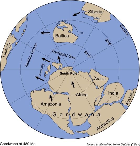
[Map from Science Direct.]
but that in a relatively short span of 40 million years both have moved at least partially into the northern hemisphere. (This isn’t the only available interpretation of evidence. It’s largely derived from paleomagnetic data. Other data sets can generate other plausible scenarios. I just think it’s fun to imagine an equatorial Moscow.)
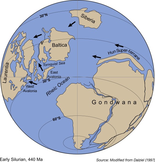
[Map from Science Direct.]
Now look back at the model of the various cratons and notice the large portions colored to indicate their age as Archean – dating it to the pre-Proterozoic. It’s on this ancient crystalline basement rock (rocks found below sedimentary basins that are metamorphic or igneous in origin) we find Moscow today.
Although it had little direct impact on the area around Moscow, the tectonic movements of the Caledonian orogeny – a mountain building era that spanned roughly 100 million years – during which Baltica made contact with Laurentia, and Avalonia and collided with both of them. This provided the time for the Volga-Uralia and Sarmatia basement segments to stabilize.
Over the course of a half billion years or so, as the platform stabilized, the territory around Moscow was repeatedly raised by endogenous processes (either folding, faulting, or volcanism) operating in the Earth’s crust along plate boundaries to form a part of a continent. Over this time, water erosion shaped some surface components and nearby sea levels rose and fell. The two processes combined to deposit a thick sedimentary layer of limestone, marl, sandstone, clay, and sand.
Central Russia saw its last marine basin about 80 million years ago during the Cretaceous period and the Earth’s crust gradually rose forming the continent called Laurasia that would eventually fragment into the present continents of North America, Europe, and Asia in the Paleogene period. As the continent formed, deep river valleys developed that, in the most recent two million years, were covered by extensive glaciation.
A few words about ice ages.
Believe it or not, we are currently living in an Ice Age. In fact, Earth has been in a geological ice age that began long before the dawn of humanity. You need to understand that a geological ice age is different from the relaxed more colloquial use of the term and that living in an ice age the planet needn’t look like the maps below.
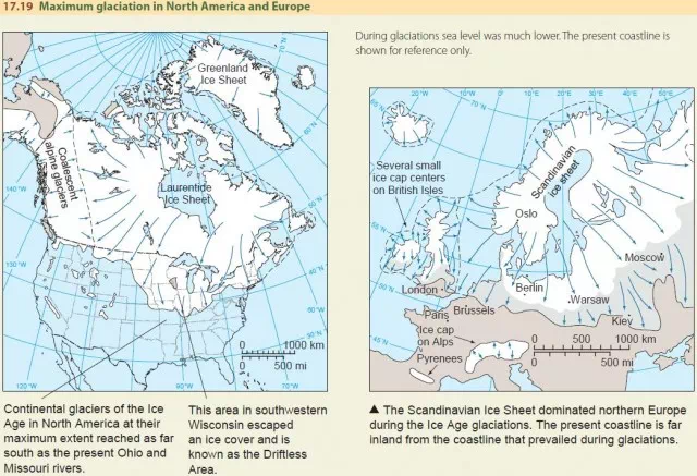
[Maps from Geography.name.]
Let’s get some definitions in place:
A glacier is a large natural accumulation of land ice that builds up when the average snowfall of the winter exceeds the amount of snow that is lost in summer by evaporation and melting and is affected by present or past motion.
Glaciation can be seen as a general term for glacier growth and glacially produced landform modification. It also describes the period when continental ice sheets grow and spread outward over vast areas.
Deglaciation occurs when ice sheets thin or melt completely. This occurs when the climate warms or snowfall decreases.
Interglaciation is the period between a deglaciation and a subsequent glaciation.
An ice age is a succession of alternating glaciations and interglaciations, spanning at least one million years.
The Late-Cenozoic Ice Age began some two-and-a-half to three million years ago according to evidence from deep-sea sediments. The last deglaciation began about 130 thousand years ago and lasted between 110,000 and 120,000 years placing us currently in an interglacial period. The glaciation shown in the map above presents the maximum extent of the Wisconsin Glaciation from about 18,000 years ago. Its deglaciation occurred rapidly spanning just a few millennia.
During the last deglaciation, western Russia including the area in and around Moscow remained covered by glacial and fluvioglacial deposits that were tens of meters thick in some places. Eventually, as the glaciers continued to retreat and melt, they left a one-and-a-half to two-and-a-half kilometer-thick sedimentary massif over the crystalline basement rock. This process formed the modern topography with the valleys of the Moscow River and its tributaries and soon thereafter, humans would arrive to reshape it.
-

Here are the songs from the México City and México City Olympics posts
May 18, 2026 -

Notes on the XIX Olympiad – the quiet protest – (México City and Me addendum three)
May 18, 2026 -

Notes on the XIX Olympiad – Successes, failures, and a Flop – (México City and Me addendum two)
May 15, 2026 -

Notes on the XIX Olympiad – Understanding Carlos and Smith – (México City and Me addendum one)
May 13, 2026 -

Y no te puedo hallar
May 11, 2026