Two days in Big Water
If this blog was something other than a vanity project, this entry would likely be the shortest in its history. It would read something like this:
We left Rio Saturday morning, took the two-hour flight to Foz do Iguaçu, left our luggage at the hotel, rode 40 minutes in a van to the Brazilian side of the Cataratas do Iguaçu (Iguaçu Falls), and gaped at them in wonder. Sunday, we crossed into Argentina, gawked at the Falls from a different angle, and Jill and I took a fabulously drenching boat ride up the river that took us under one of the cataracts.
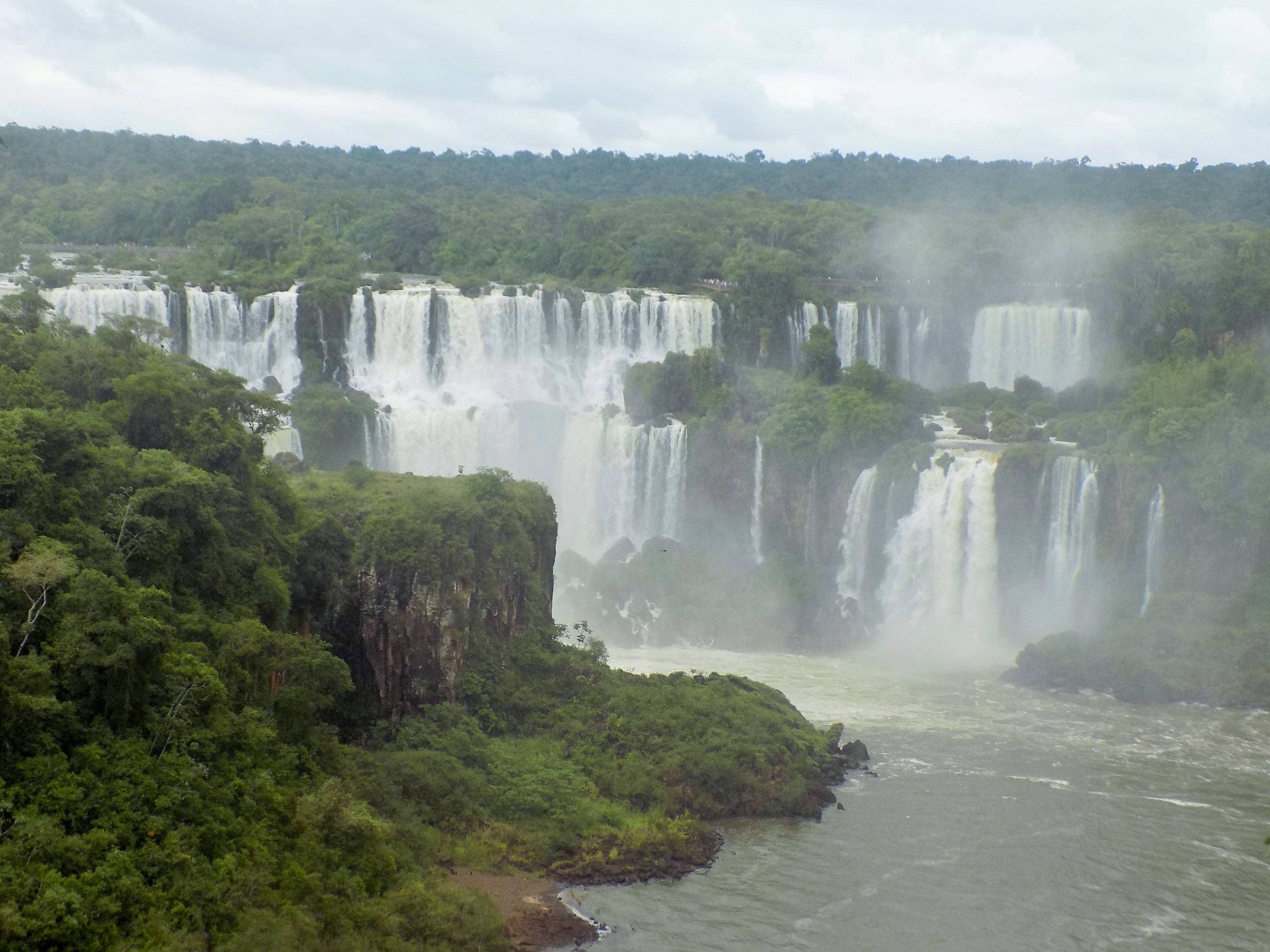
I’d then post a photo like this one,
a pair of links to my photos and videos (and those that Jan shared with me) of the Brazilian and Argentine views, STFU (as the texters say), and start writing about the bus ride to Asuncion. Unfortunately for you, dear reader, this is essentially a vanity project and one for which I’ve done enough research that I’m determined to try to impress you with the result. So, since you’ve read the TL;DR version, feel free to skip ahead to find the links and just look at the pictures and videos. Or take a deep breath and read on because we’re about to take another trip into our planet’s geological past and then enhance that with the local creation story to add some color.
(Note: While writing from the Brazilian side, I’ll use the Portuguese spelling. Once in Argentina, I will use Spanish orthography or Iguazú.)
Return to Gondwana.
Recall from a previous entry that 180 million years or so ago in the Jurassic period the super-continent Gondwana began to break apart. One outcome was the separation of South America from Africa that created rifts and fracture zones in the process. We also learned that the Tristan da Cunha hotspot was busy spewing plumes of magma from deep inside the Earth’s mantle. These volcanic eruptions are critical in the formation of these waterfalls.
When magma reaches the Earth’s surface, it begins a cooling process. We call that lava. Scientists (geologists, volcanologists, seismologists) distinguish three (or four) main types of lava based on their chemistry which is determined by the magma temperature, its viscosity, and the manner of its eruption. These types are felsic (high in viscosity and silica), intermediate (somewhat higher in temperature, less viscous, and comprised of transitional content from silica and aluminum to more magnesium and iron), and mafic (characterized by high temperature eruptions and high levels of magnesium and iron). The last category, also called basaltic lava, is found at Iguaçu. Basalt forms when mafic lava cools on the Earth’s surface. The terms basaltic lava and mafic lava are often used interchangeably.
(I particularly like science’s use of Hawaiian words {for which we can thank Clarence Dutton} to describe lava flow. A’ā refers to basaltic lava characterized by rough and rubbly surfaces. Pāhoehoe is a basaltic lava with a smooth undulating surface. It’s the latter type we find at Iguaçu.)
The activity of the tectonic movement and active volcanism along the rifting zones prompted two somewhat oppositional actions. Continental spreading created a minor uplift of the landmass as it broke apart while extensional forces thinned the crust causing some areas to subside. This early subsidence created fissures and channels for the lava to fill along the southern part of the South American Plate. The Pāhoehoe flow created hard, flat lying, and less erodible layers that the nascent rivers meandered across over time.
Although you can see the nearly one-kilometer width of the river as it approaches the falls and the sharp northward turn it takes into the much narrower (125 meters) channel downstream of the cataracts, what you can’t see from this NASA satellite photo,
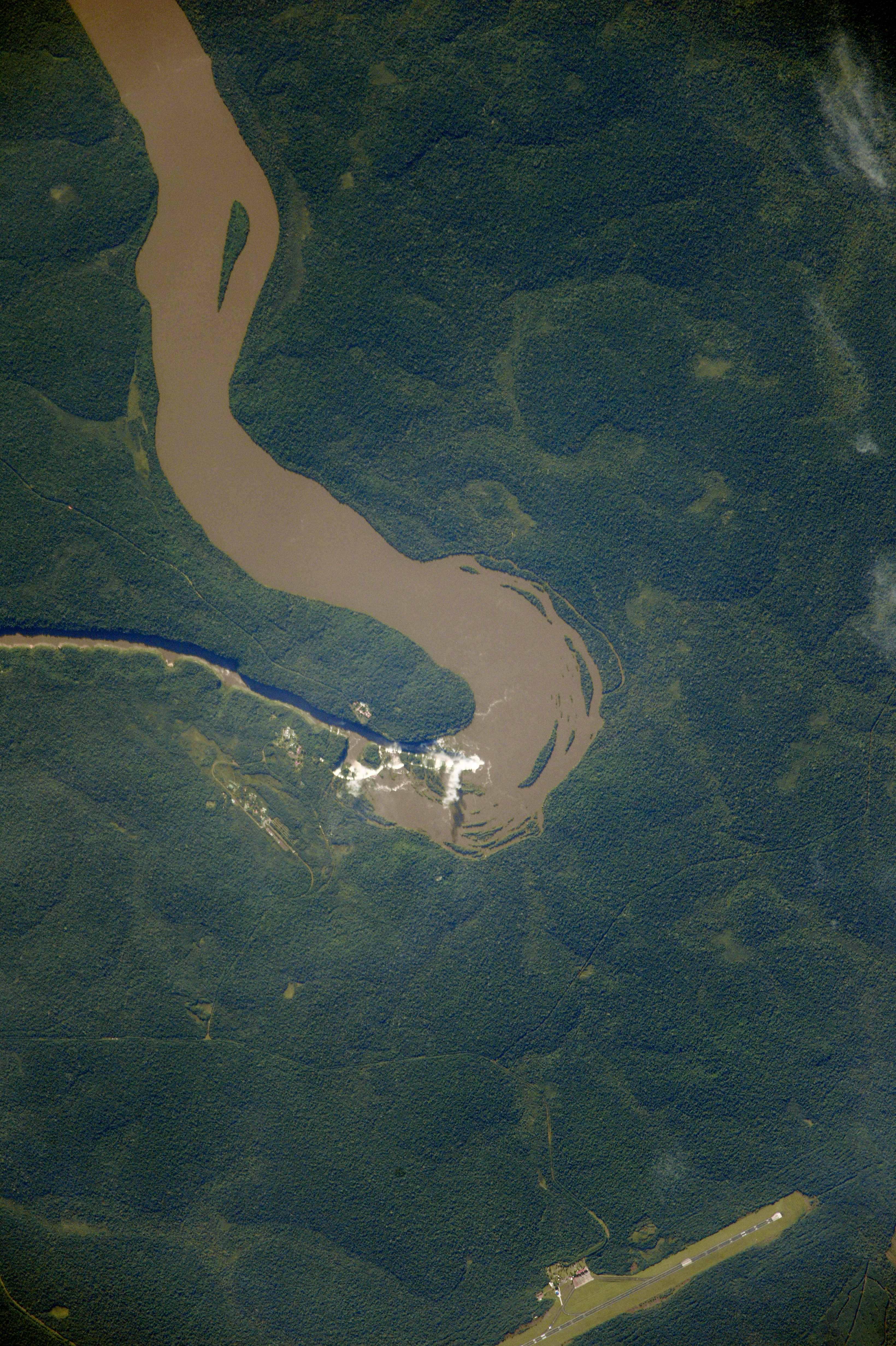
is the thickness of the basalt layer. The basaltic pile is nearly a kilometer thick and its reluctance to erode means that the falls are very young from a geologic perspective.
The Iguaçu River rises in Brazil in the Serra do Mar near Curitiba and mainly flows from east to west for 1,320 kilometers as it meanders across the Paraná plateau at the southern end of the Serra do Mar. The plateau appears to have formed during a sudden period of uplift about 80 million years ago. The massive lava flows, also known as basalt floods, had already laid down the basalt layers making the Paraná Continental Flood Basalt Province (or Paraná Sedimentary Basin) among the world’s largest. It covers an area of nearly 1,250,000 square kilometers spreading over parts of southern Brazil, northern Argentina, Paraguay, and Uruguay. (A sedimentary basin is a depression in the crust of the Earth formed by plate tectonic activity in which sediments accumulate.)
After uplift created the plateau, a slow process of erosion allowed the genesis of the falls we see today (Rivers want to find the fastest downhill route to sea level.). However, on a geologic timescale, the falls on the Iguaçu River are mere infants. It’s only in the past 20,000 – 25,000 years that the river finally exploited the natural breaks and weaknesses within the bedrock generating the massive flow volume that so impresses its human visitors. (On average the flow volume is 1,746 cubic meters per second over a year but has had a flow recorded as high as 46,800 cubic meters per second in June 2014.) The falls, which, like Niagara Falls in the United States, are gradually receding due to erosion, were at one time very near Iguaçu’s confluence with the Paraná.
As you can see from the photo at the top of this entry, the falls are, in many places a two-step waterfall with the steps typically between 35 and 40 meters high. Three layers of columnar basalt rock contribute to the staircase effect. The tops of the columns are characterized by 8–10 meters of highly resistant vesicular basalt and this controls the shape of the falls to a large degree. (Vesicular basalt contains lots of small cavities called vesicles that form when expanding gas bubbles become trapped inside lava and don’t escape before the rock cools.)
Although about 900 meters of the nearly 2,700 meter-long falls has no water flowing over it, Iguaçu is considered the widest true waterfall in the world. A number of islands along the edge divide the falls into many separate cataracts that vary between 60 and 82 meters high. I can’t tell you how many falls we saw but I was told that the number fluctuates from 150 to 300. Many of these falls, some of which have names such as San Martín, Adam and Eva, Penoni, and Bergano, merge into a single wall of water during flood stage.
About half of the river’s flow falls into this
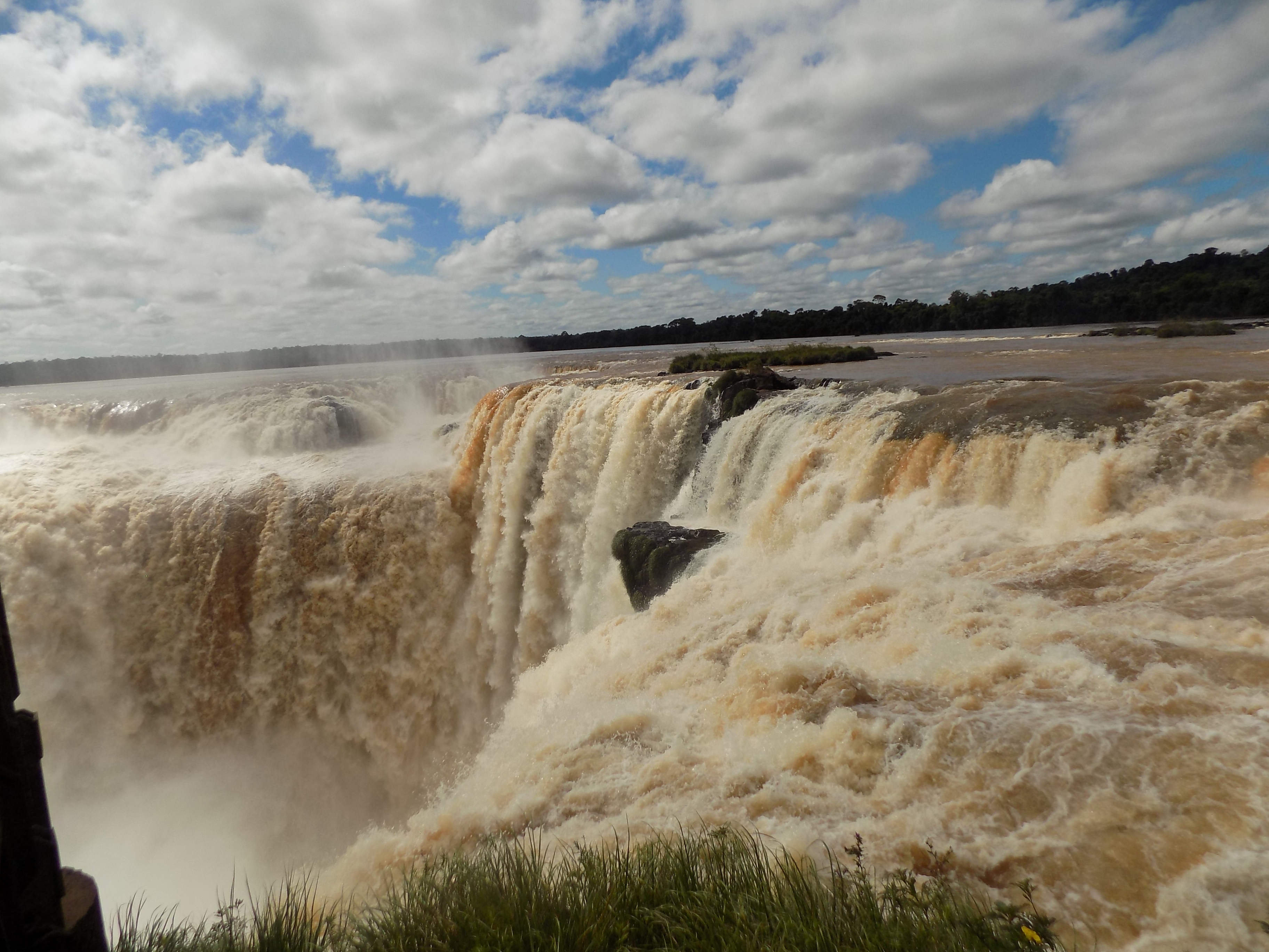
long and narrow chasm called Garganta do Diablo by Brazilians, Garganta del Diablo by Argentinians and Devil’s Throat by English speaking tourists. (Although in the next post I’ll tell the Guaraní story of the falls, I couldn’t find this indigenous people’s term for the Devil’s Throat.) To provide a better idea of its size, this canyon is 80 – 90 meters wide and between 70 and 80 meters deep.
-

Here are the songs from the México City and México City Olympics posts
May 18, 2026 -

Notes on the XIX Olympiad – the quiet protest – (México City and Me addendum three)
May 18, 2026 -

Notes on the XIX Olympiad – Successes, failures, and a Flop – (México City and Me addendum two)
May 15, 2026 -

Notes on the XIX Olympiad – Understanding Carlos and Smith – (México City and Me addendum one)
May 13, 2026 -

Y no te puedo hallar
May 11, 2026