The Salt Lake – Great yet not so great – Part 2
Why the Salt Lake is great – and why it isn’t.
I’d guess that no visit to Salt Lake City can be considered complete without at least introducing oneself to the body of water for which the borough is named so, of course, I had to at least dip my toe into it. And I’d also guess that by now you know that I’m incapable of simply declaring that I did so but that I need to write a brief treatise about the lake to accompany my toe dip.
Let’s start with what’s great about the Great Salt Lake. The first point is simple and straightforward: It’s the largest lake west of the Mississippi River and the largest salt lake in the Western Hemisphere. How big is it or, more accurately, how big was it? Until the 21st century, in a typical year, its surface area averaged 1,700 square miles though it could swell to more than 2,100 square miles. That made it larger than the state of Rhode Island and, in many years, larger than the land area of Delaware as well.
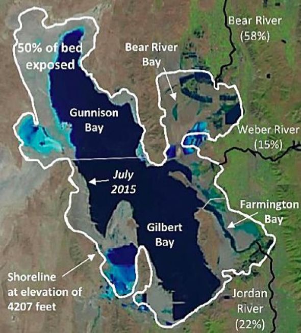
However, by 2016, the lake covered an area barely more than 1,000 square miles. Its surface elevation, which peaked at 4,212 feet in 1986 now equals its lowest point of 4191 feet to which it first declined in 1963. Because the lake has an average depth of only 14 feet (33 feet at its deepest point) a foot of water loss can make a significant difference in its total size. Here’s what that can look like [Map from accuweather.].
How the lake came to be.
As the glaciers retreated at the end of the last ice age, the process created Lake Bonneville which was actually a freshwater lake. (Bonneville is named in honor of the French explorer Benjamin Bonneville who, in 1837, was the first to map the outlines of the Great Salt Lake.) At 325 miles long, 135 miles wide and 1,000 feet deep, Lake Bonneville was a bit less than one and a half times the size of Lake Superior – meaning it was enormous.
About 17,000 years ago, Lake Bonneville overflowed at Red Rock Pass in Idaho and a yearlong flood ensued during which time the lake lost about 375 feet of water. As Lake Bonneville shrank, all of the minerals in it — including salt — concentrated into steadily less water and over time, the modern Great Salt Lake emerged about 10,000 years ago. (All freshwater bodies have some mineral content because rainwater leaches it from rocks and soil.)
If you look at the image above, you can see that the lake is fed by three rivers – Jordan, Weber, and Bear. You need to note this for two reasons – one of which will become important later in the discussion. For now, just note that three flow in but none flow out. This makes the Great Salt Lake a terminal lake.
Left to only natural processes, a terminal lake would hold everything that enters it except water which it loses to evaporation. Together, in addition to the water they carry, the three rivers make an annual deposit of between 1,100,000 and 2,200,000 tons of leftover minerals – mostly salt – from the extinct Lake Bonneville into the Great Salt Lake.
In the map above, you see the northern section of the lake is called Gunnison Bay while the southern section bears the name Gilbert Bay. Since all three rivers flow into the Gilbert Bay section of the lake, the northern arm is naturally more saline. It maintains a relatively steady salinity level near 25 percent while the southern arm can fluctuate – dipping as low as six percent or rising as high as 27 percent.
Natural processes aren’t the only forces at work on the lake, however. For example, five businesses extract salt and other minerals from the Great Salt Lake through solar evaporation ponds. Although no food-grade salt comes from the lake, the extracted salt is used for deicers, road salt, water softeners, and salt licks for livestock.
Two lakes in one.
In the course of my research about the Great Salt Lake, I happened across this rather curious NASA satellite image that provides a stark contrast between Gunnison and Gilbert Bays:
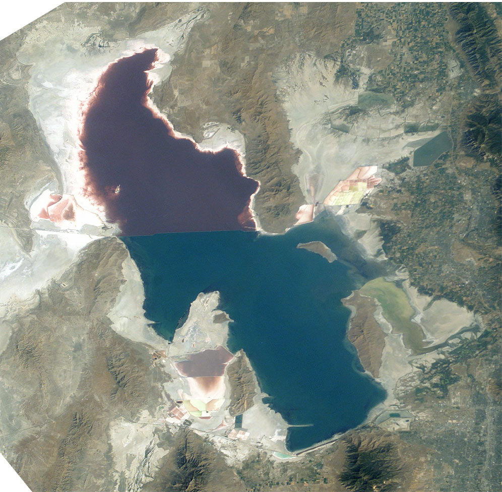
When I saw the two distinct colors, it fed a new mental tributary for my research to follow – a not uncommon occurrence. Although I knew about the water inflow and salinity differences between the northern and southern sections of the lake, I didn’t think that would account for such a stark difference in coloration particularly one that seemed so linearly definitive. I was right.
Here’s why. Recall that the first transcontinental railroad was completed in 1869 at Promontory Point. In 1904, the Southern Pacific Railroad built a causeway across the lake that created not merely a shorter route that saved 42 miles but one of lesser grade and curvature thereby generating even greater time savings.
The initial causeway consisted of two earth and rock-fill embankments extending from each side of the lake that were joined by a 12-mile open, wooden trestle that allowed the continuation of the natural exchange of water between the two bays. Maintaining the trestle proved to be quite costly and by the early 1950s, when maintenance costs became too high, the trestle was dismantled and replaced by a solid rock-fill causeway. Even without the photographic evidence, you can probably guess what happened.
While the open structure of the trestle allowed for the free mixing of brine water between the north and south arms of the lake, the solid causeway effectively divided the lake into two bodies by halting the mixing of water. Anyone think there were some unanticipated environmental consequences?
Now we must return to the geography of the three rivers. Since they all feed the lake south of the causeway, the northern arm experienced the natural hydrological process of evaporation but, with all the inflow from the southern arm to replace any of the evaporated water cut off by the causeway, its salinity increased to the point where the water became too saline for even the brine shrimp – one of the few species of plant or animal in that part of the lake – to survive.
Eventually, in 1988 in an attempt to rectify or at least mitigate the damage, engineers opened a 30-meter breach in the causeway. That first effort allowed the elevations and salinity to equalize to a certain extent. Still later, they installed three large pumps to keep salinity in the north arm at saturation levels of about 25 percent while the south arm continues its natural fluctuation.
But the damage couldn’t be fully repaired and the salinity difference has created two different ecosystems on the lake that account for the different coloration. The south arm is dominated by blue-green algae, which colors its water green. On the north arm, higher salt content has promoted the dominance of a different type of algae called Dunaliella Salina. The north arm’s wine-red color results from the beta-carotene and bacteria this algae releases.
And speaking of bacterial emissions, I was fortunate not to experience the effects of bacterial effluvia that so many in Salt Lake City cope with from time to time. You see, the Great Salt Lake is famous for occasionally emitting rotten egg odor. It’s a natural process. Some species of bacteria residing in the lakebed exhale hydrogen sulfide and when that bacterial count is high, the lake emanates the unpleasant odor associated with that molecule.
On my walk across that long stretch of exposed lakebed, I did encounter something else for which the lake is famous – brine flies. Although it’s said the flies don’t bite people, I found their preponderant swarming presence discomfiting enough that, once my toe touched the water, I quickly retreated. I tried to capture the flies in one of my photos but this video does a better job (even if it’s a little shaky).
In the next post, I’ll finally reveal what I saw on the news that prompted my schedule change.
-

Here are the songs from the México City and México City Olympics posts
May 18, 2026 -

Notes on the XIX Olympiad – the quiet protest – (México City and Me addendum three)
May 18, 2026 -

Notes on the XIX Olympiad – Successes, failures, and a Flop – (México City and Me addendum two)
May 15, 2026 -

Notes on the XIX Olympiad – Understanding Carlos and Smith – (México City and Me addendum one)
May 13, 2026 -

Y no te puedo hallar
May 11, 2026