Rio de Janeiro in the time before humans (Rio and Me supplement one)
I’ll make this confession at the start: Those of you who read my initial posts about Rio might recognize most of the text to follow because for the second time in this series I’m going to simply copy much of that original post. While I plan to add some new information, you can find most of what you need to know about Rio’s geomorphology from that post and I see no need to duplicate that effort. With that said, let’s get started.
Another wander back to Gondwana.
I suspect that anyone who has looked at a globe or a global map has noticed that it requires little imagination to envision the east coast of South America connecting with Africa’s west coast and locking together rather like a jigsaw puzzle. It might have looked like this:

[Rights to John Pangaea.]
As you can see, the breakup of the super continent occurred relatively recently – at least from a geological perspective. The map above shows the approximate configuration of Gondwana in the late Jurassic period about 195 million years ago. South America’s divorce from Africa (which was really neither’s fault – they simply drifted apart) began in the early Cretaceous or about 140 million years ago. (Despite the lack of evidence, some people argue that Africa’s desire for big brained hominid children – the continent did give rise to the earliest hominids some 5,800,000 to 6 million years ago – prompted the breakup.) One outcome of the split is that over the next 75 to 100 million years give or take we see the opening of the south Atlantic.
But the period wasn’t characterized by tectonic movement and ocean creation alone. As the gulf between the continents widened, four major oceanic segments marked by three fracture zones make convenient markers to define sections within the southern Atlantic.
(A fracture zone is a long, narrow rift on the ocean floor separating areas of differing depth of up to 1,500 meters. Of importance to the present discussion is that in places where such a zone crosses a mid-ocean ridge, it displaces the ridge by faulting. Faulting, of course, occurs in the Earth’s crust as a brittle response to stress which, in turn, is generally caused by plate tectonics.
In the present instance we must focus our attention on the southern segment demarcated by the Florianopolis Fracture Zone in the north and the Agulhas-Falkland Fracture Zone on the south. It is the volcanic and tectonic activity in this range that will not only give rise to the rock formations dotting the general area of Rio de Janeiro but will, through the magmatism of the Tristan da Cunha hotspot also engender the Paraná Basin and provide the tectonic energy to elevate the Andes Mountains.)
Rio’s formations might look imposing but they’re really gneiss. Please don’t take them for granite.
Mention Rio de Janeiro and it’s probable that it immediately evokes visions of beaches, bikinis, Speedos, and Carnival. It’s also likely that when you think of Rio an image something like this one
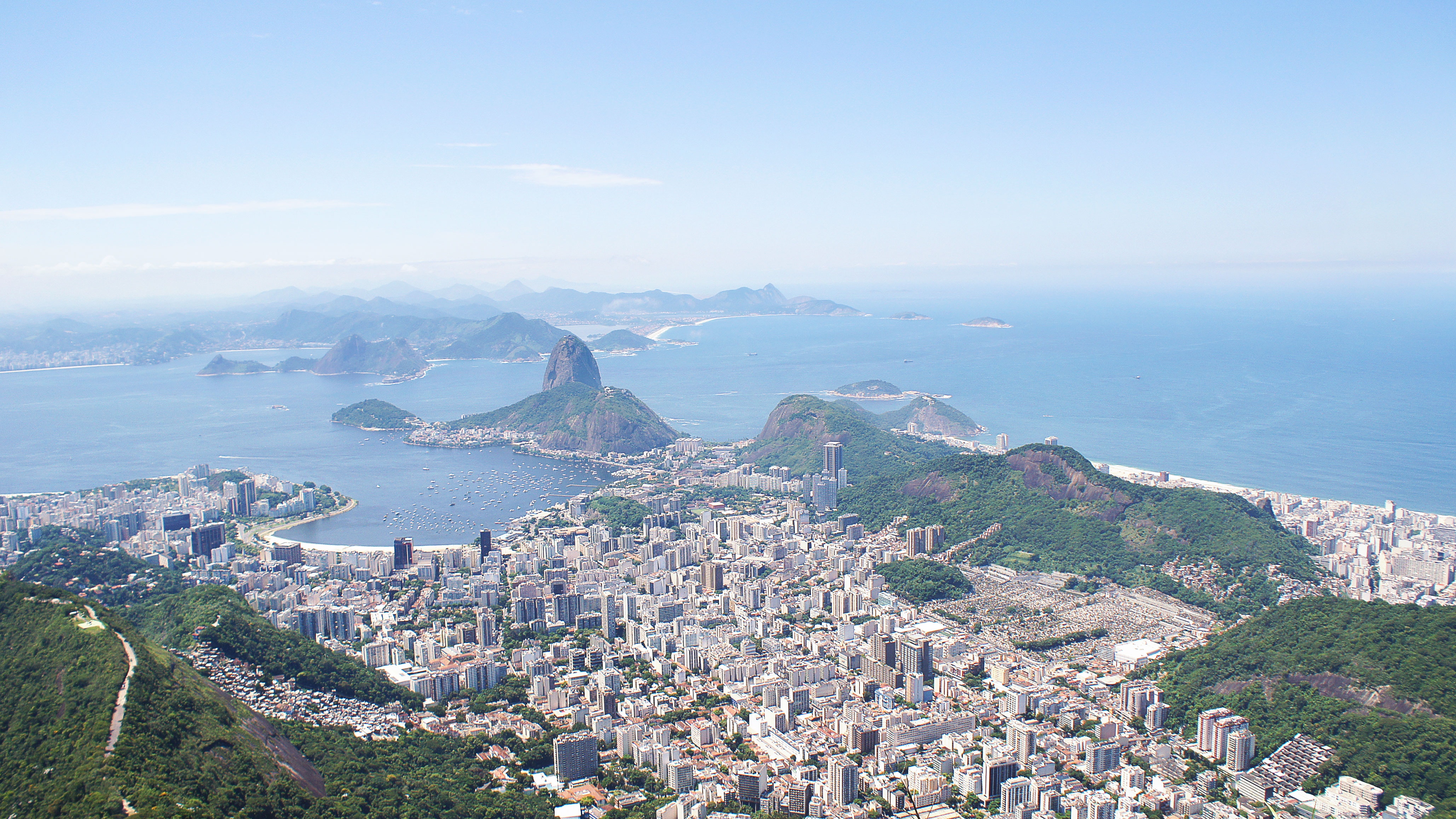
that includes what UNESCO calls Carioca landscapes, dynamic urban constructions, and beaches nestled between bornhardts enters your imagination. While the term bornhardt – a dome-shaped, steep-sided, bald rock outcropping at least 30 meters in height and several hundred meters in width and named after Wilhelm Bornhardt the German geologist who first described the feature – might not come to mind, the domed hills and mountains such as Corcovado and Pão de Açúcar (Sugarloaf Mountain) – the latter visible in this photo – almost certainly do.
On 3 April 1832, the HMS Beagle sailed into Guanabara Bay. Its most famous passenger, Charles Darwin, decided to explore the geology of the immediate region and climbed the nearly 400 meters to the top of Pão de Açúcar. His description,
This whole district is almost exclusively formed of gneiss, abounding with garnets, and porphyritic with large crystals, even three and four inches in length, of orthoclase feldspar: in these crystals, mica and garnets are often enclosed.
Nothing can be more striking than the effect of these huge rounded masses of naked rock rising out of the most luxuriant vegetation.
was quite accurate.
How did these “huge rounded masses of naked rock” come to be? Parts of Gondwana (think Laurasia and North America) had begun to slowly break apart hundreds of millions of years before the rift that separated South America from Africa. Throughout both processes, large bodies formed from magma fed by the Tristan da Cunha hotspot intruded into the weakened crust.
(A hot spot is a place where plumes of molten lava rise from deep within the Earth’s mantle and melt through the overlying tectonic plate. This process supplies magma to seamounts which are individual volcanoes on the ocean floor.
A tectonic plate passing over a hot spot creates a chain of volcanoes. The Hawaiian Islands, the Azores, and the Galapagos Islands are examples of hot spot chains.
As for Tristan da Cunha, it is considered the world’s most isolated populated island. You can find its general location in the middle of the southern Atlantic by drawing a line from Cape Town, South Africa to Florianopolis, Brazil.)
As they cooled in the upper crust these magmatic bodies formed a large granitic pluton (a body of intrusive igneous rock). During the movement of the continents parts of the pluton broke apart, a process of metamorphism and deformation of the rocks occurred and the cleavage of the gneiss formed. More recently, the metamorphic pluton was pushed upward. Darwin’s assessment of the mountain’s composition was correct. Hard augen-gneiss towered above weaker rocks which had slowly eroded and formed the dramatic modern landscape of Rio. The hard gneiss could date back as much as 570 million years. (The fact that similar magmatic structures can be found along the coasts of Africa and South America presents further evidence of continental drift.)
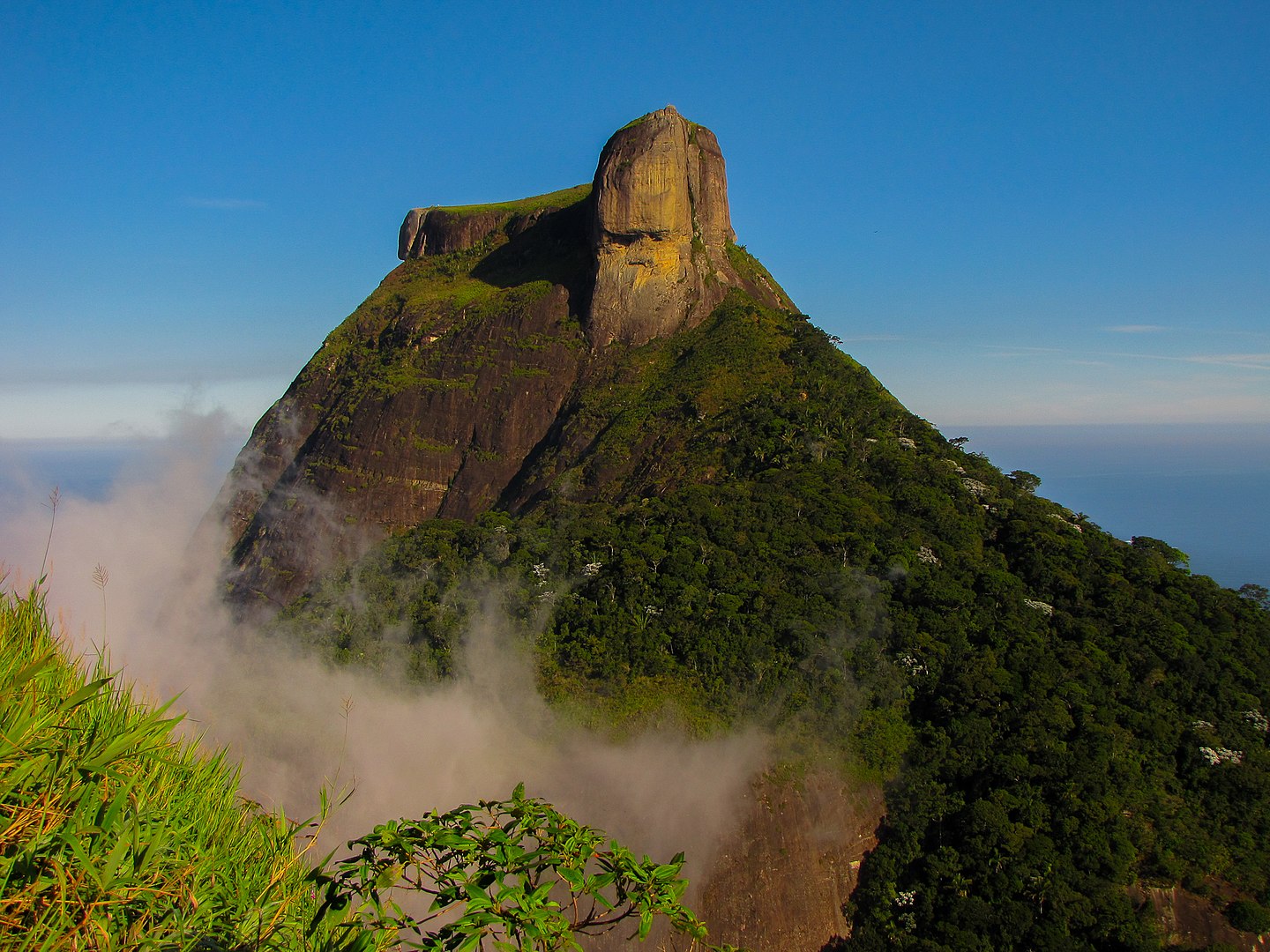
While Corcovado and Pão de Açúcar are probably the best known formations, two other bornhardts, Pedra da Gávea and Morro Dois Irmãos or Two Brothers Mountain are also quite striking. Just 10 kilometers or so west of Copacabana Beach, in the southern section of Tijuca National Park, Pedra da Gávea towers nearly 850 meters above Conrado Beach.
Pedra da Gávea is a monolithic granite dome akin to its neighbor Pão de Açúcar or even to Stone Mountain near Atlanta that I mentioned early in this series. Like other formations in and around Rio it is composed of granite (top 150 meters) and more ancient gneiss. Although it’s likely the result of differential weathering and erosion, in a fine example of pareidolia
[Photo from Wikimedia Commons By KarlaFPaiva CC BY-SA 3.o.]
many people see a face on one side of the rock. A bit to the northwest of Pedra da Gávea (Topsail Rock) is Pedra Bonita which is the launch point for hang gliders who will soar 10 kilometers south to the Morro Dois Irmãos
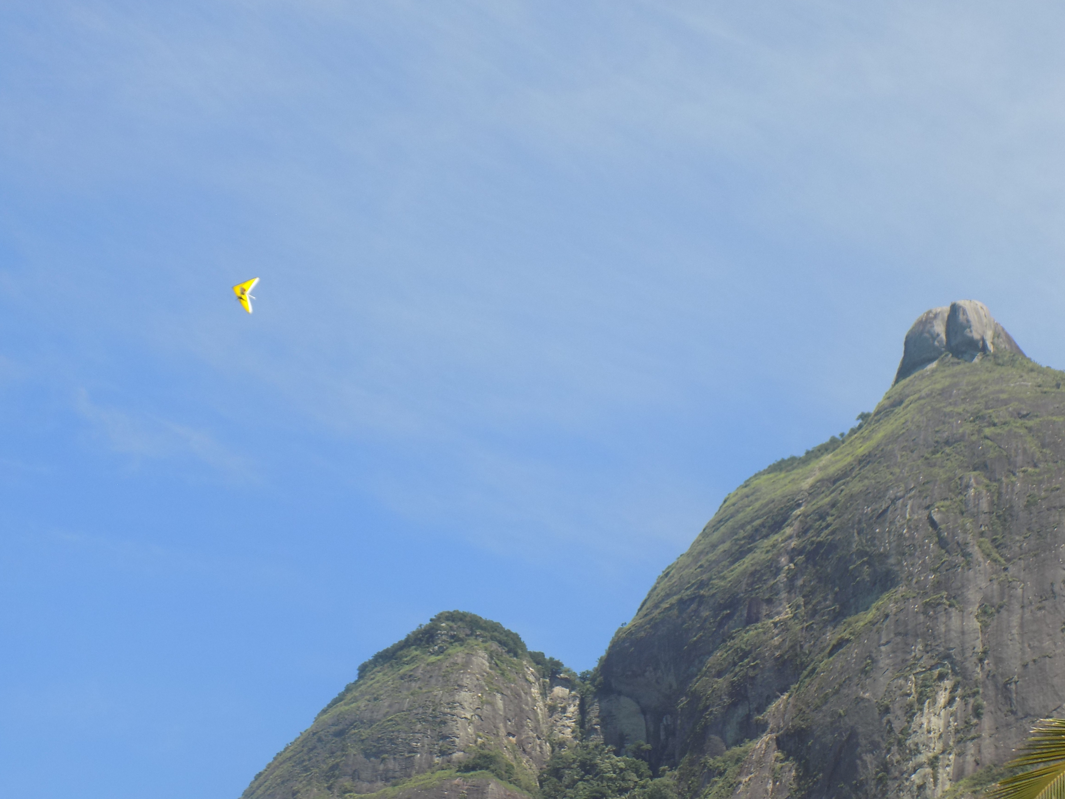
before returning to touch down on the Praia de São Conrado.
-

Here are the songs from the México City and México City Olympics posts
May 18, 2026 -

Notes on the XIX Olympiad – the quiet protest – (México City and Me addendum three)
May 18, 2026 -

Notes on the XIX Olympiad – Successes, failures, and a Flop – (México City and Me addendum two)
May 15, 2026 -

Notes on the XIX Olympiad – Understanding Carlos and Smith – (México City and Me addendum one)
May 13, 2026 -

Y no te puedo hallar
May 11, 2026