A few words of introduction.
Midway through my research into the early geology of Japan it struck me that over all the years and entries I’ve made in this travel blog I’ve provided little, if any, information about my process of gathering, synthesizing, and ultimately summarizing the information gleaned from uncounted hours of research. I note it now because a frequent step in my process is making an effort to reconcile conflicting interpretations of geological and archaeological evidence or different historical accounts of significant events to say nothing of editing the all too frequent tangential roads and riverways that often entice me to stray from the original focus.
I think no location has demanded more of this discipline than Japan. I suspect the information would be clearer and the conflicts fewer if I read and understood Japanese. Alas, beyond my normal words of greeting and courtesy – which I can speak but read not at all – this is not the case. I can only promise to endeavor to maximize my accuracy and limit my equivocation.
Relatively speaking Japan is an adolescent.
According to National Geographic, “Earth is estimated to be 4.54 billion years old, plus or minus about 50 million years.” The bulk of the land masses that comprise the islands of Japan as we see them today began reaching the surface in the Cambrian Period about 500 million years ago (MYA). Of course, as with much in the geologic record, we can trace some elements much further back in time and a recent discovery near Hiroshima unearthed the oldest known rock dated to about 2,500MYA.
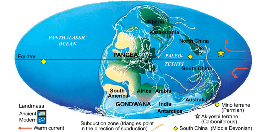
For now, let’s look back 750 million years to the breakup of one of Earth’s early supercontinents Rodinia. As Rodinia broke apart it made room for a large ocean called the Panthalassic when the planet might have looked something like this:
[Map from Researchgate.]
You might recognize the names of some of the later supercontinents from some other posts on this site.
Notice that along the eastern side of the Panthalassic you see a number of subduction zones in the areas labeled North China and South China. (Subduction, you may recall, is often part of the mountain building process. It happens when two tectonic plates collide and one is forced to go beneath the other one and becomes part of the mantle while simultaneously recycling part of the continental crust.) Subduction was one of the main processes that built the Japanese archipelago over the ensuing half billion years. By the time of the Jurassic Period, the islands are being built through accretionary processes (wherein material from the outer plate and trench is removed and added to the outer continental margin sometimes through a mechanism of thrusting and folding). This forms the backbone of the archipelago.
More recently, we can see a clear division between the western part of Japan where we find mainly Cretaceous to Paleogene felsic volcanic and plutonic rocks and the eastern part of the country which is covered extensively by Neogene sedimentary and volcanic rocks. During the Quaternary (the past 2.6 million years), volcanoes erupted in various parts of Japan, and alluvial plains formed along the coastlines.
Japan sits on a burning Ring of Fire.
Japan is a beautiful country of soaring mountains painted in a broad range of different shades of green punctuated by often unexpected bursts of different colors and areas of flatland covered with meticulously maintained rice paddies. It’s a wonder to visit. However, if you are someone who’s fond of geological stability, it almost certainly wouldn’t be your first choice of a place to reside.
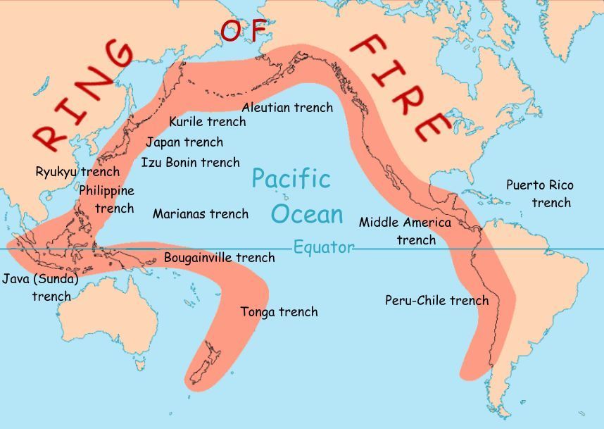
Follow the arc of the map below
[From National Geographic and USGS.]
and the area called the Ring of Fire or more specifically, the Pacific Ring of Fire. It’s an area that has earned its moniker. The best geological estimates place 452 of the world’s 600 or so volcanoes known to have erupted in human history in the Pacific Ring of Fire. Even looking at pre-history, scientists have been able to determine that 22 of the 25 largest eruptions have occurred in this burning ring of fire. Our humble planet holds another 750 potentially active volcanoes. You can find more than 100 in Japan.
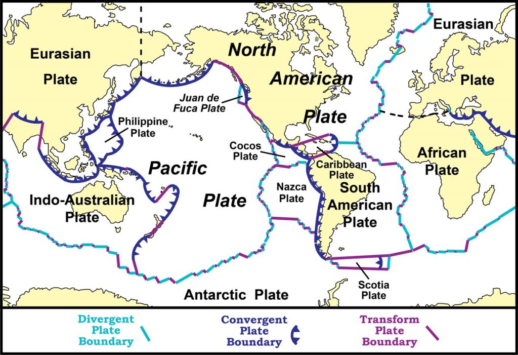
Further, 90 percent of our home world’s earthquakes occur in this region as well. This map
[Map from National Park Service.]
shows why. The massive Pacific plate is either knifing under or spooning against many smaller more dessert sized plates with the forks at the boundaries creating an entire place setting. If you look closely, you can see that Japan is located at the junction of not two but four tectonic plates – the Pacific, Philippine, Eurasian, and North American. Note that all of these plate boundaries are convergent meaning they are pushing against each other and eventually, one will slide under the other – et voila! subduction. And also, EARTHQUAAAAKE!
According to the Meteorological Agency of Japan, approximately 2000 earthquakes strike in the island nation annually. Many of these are small temblors with seismic readings of between one and two so with this in mind, it’s easy to understand why no one was particularly phased by the minor but measurable quake that occurred during the Nagano Olympics.
However, one needs to keep in mind that an earthquake needn’t shake any of the islands per se to create a massive human disaster. We need only look back to the 2011 Tōhoku quake to remind us of this danger. The massive (9.0-9.1) quake’s epicenter was more than 70 kilometers east of the Oshika Peninsula. It lasted nearly six minutes and generated a tsunami worthy of a disaster movie. Some estimates include a wave height of 40.5 meters, a speed in some areas of 700 kilometers per hour, and a 10 kilometer inland travel distance. This wave caused the Fukushima Daiichi nuclear disaster.
With all of that said, if you like living on the edge seismically speaking, Japan may be just the place for you.
And you didn’t think you were going to get away without this, did you?


a comment to see if you follow from portugal. interesting geological lesson. umwlax up to 4! still must get past nu again. good article in dbk about brenda and katie this past season.
I check in but only occasionally
I always look forward to your before the ___ articles. Your research is so extensive, I often google your references to learn more…they are always on point and relevant to your narrative.
Speaking of Tsunami’s…my favorite stat..
“Some estimates include a wave height of between 40 and 41 meters, a speed in some areas of 700 kilometers per hour, and a 10 kilometer inland travel distance.”
Mother Nature or Gaea (Mamba Jamba to me) is undefeated and always will be until proven otherwise…
The funny thing is that someone texted me today that he always skips the “before” posts. Not his thing. And I’m fine with that. It’s why I’ve tried to be consistent and clear in their titles. (I think he’s losing out but that’s his choice and I’m happy he’s reading and enjoying the other posts.)
On another note,
“Mother Nature or Gaea (Mamba Jamba to me) is undefeated and always will be until proven otherwise…”
spot on truth. That’s the thing about global warming. Whether human caused or not, in the end, Mamba Jamba is going to win. What she will do to humanity (or most of our species) remains an open question.