Falling for Plitvice – part 1
Our main stop today will be one of the most scenic and photographed places in Croatia – Plitvice Lakes (pronounced plit-vee-chuh) – and will almost certainly be one occasion when you, as readers, might celebrate the loss of my camera simply because the photos I’ll download will likely surpass any I took. But, on our way we’ll make a somewhat ironic (though ironic by choice) stop at Karlovac.
We needed to pass through Karlovac enroute from Zagreb to Plitvice and when we reached the town, we stopped at the open-air Museum of Army Collections from the Croatian Homeland War. The museum is technically in a suburb of Karlovac called Turanj (more on that spot in a moment) and the irony of our brief stop in Karlovac is that Croatians call the city grad parkova (the city of parks) and grad na četiri rijeke (the city of four rivers) so in a place known for its parks and rivers, we stopped at a war museum. Here’s a look at the museum and the area from above.
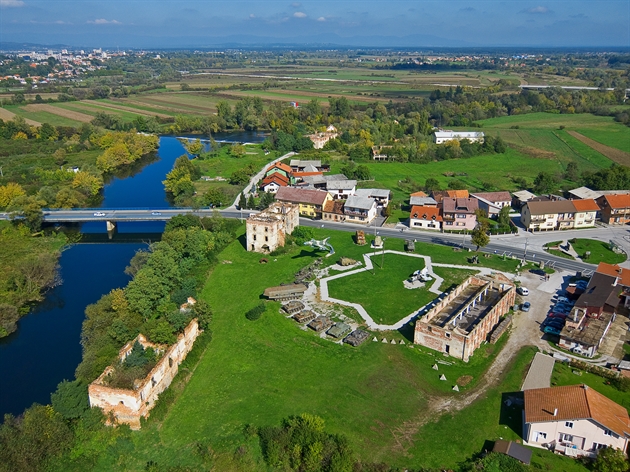
(Karlovac was established as a fortress in 1579 by the Austrians to serve as a southern bulwark against the Ottomans. Turanj {meaning tower in Croatian} was established in the same period when a wooden tower was erected along the Korana River {seen in the photo} as an advance guard post.)
Why Karlovac?
As you’ve read through the history I’ve included in this journal, you should have concluded that the notion of establishing a Greater Serbia long predated the various independence declarations in the 1990s of the former Yugoslav republics. It had its seeds sown centuries ago.
According to the 1991 census in Croatia, the ethnic population of the municipality of Karlovac was nearly 64 percent Croat, 27 percent Serb, and nine and a half percent other. Despite being outnumbered by nearly two and a half to one, the Serbs saw the area around Karlovac as rightfully part of Greater Serbia. In fact, this map (from Wikimedia) shows the extent of Serbian ambition:
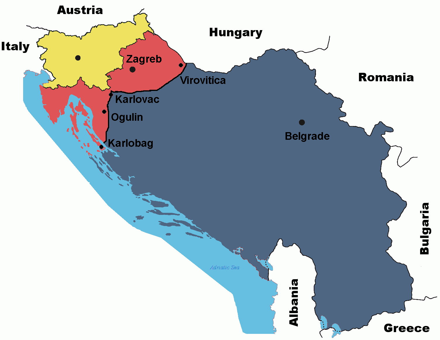 Notice that you don’t see Macedonia, Montenegro, Kosovo, Bosnia and Herzegovina, and much of Croatia. For reference, Karlovac is about 60 kilometers southwest of Zagreb. The unlabeled yellow area is Slovenia and the black dot is its capital Ljubljana. Such was the extent of Serbian territorial voracity.
Remember that after the Croatian independence referendum Serbian forces ferociously attacked Osijek (where Serbs made up only about 20 percent of the population) in Slavonia – the area east of Zagreb bordering on Hungary and Slovenia. After declaring a state (never internationally recognized) called the Republic of Serbian Krajina that, while it didn’t include Karlovac, did include much of the area near it as well as a significant portion of western Croatia extending a bit south of Knin, they attacked Karlovac in much the same way they had attacked Osijek.
The Serbs inflicted heavy damage by both shelling the city from some distance and launching more than one offensive against the town. Each time, the Croatian Army held the area including at Turanj and warded off the Serbian attempts to seize control of the city. This success is among the factors that led the government to making the somewhat ironic choice of establishing the war museum in the city of parks.
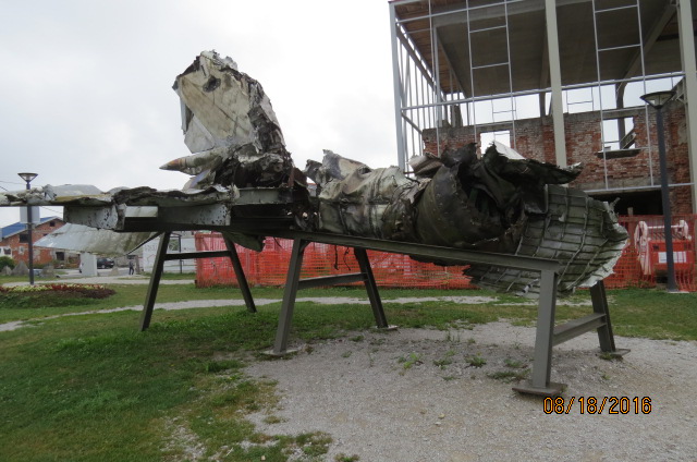
In addition to the tanks and the intact fighter jet (just to the left of center in the aerial photo), the museum display includes a downed fighter plane (Pat’s photo) and other ordinance.
The brick building shell behind mangled jet was a school. The visible construction behind the plane is for an expanded museum and not to replace the school. Another army barracks stood in this general area that the soldiers described with their own bit of dark humor.
[Downloaded from the website Follow the Flammias.]
One result of the fighting that we couldn’t see is the shift in the ethnic makeup of the city. It’s now more than 88 percent Croat and only eight percent Serb. The result we could see is that many of the buildings we passed on our way into and out of town – whether residential, commercial, or civic – still display the scars of the Croatian Homeland War.
More beautiful than Veronica.
Here’s something I knew as we left Karlovac: Our next stop was going to be at Plitvice Lakes National Park – a UNESCO World Heritage Site considered one of the most beautiful spots in Croatia. Here’s something I didn’t know: As Karlovac receded into mirrors and memory, so too would our exposure to nearly all traces of the wars that had ravaged so much of the Balkans a quarter century past. (Although there was an “incident” at Plitvice, it wasn’t something we discussed so I’m excluding it from the present report.)
Choose your preferred internet search engine and search for “European national parks” or “most beautiful European national parks” and Plitvice Lakes will appear at or near the top of almost every result. And with good reason.
The park, established in 1949 and nearly 300 square kilometers in size, is nestled in a region of the Dinaric Alps in Likka-Senj and Karlovac Counties on the western side of Croatia about 55 kilometers from the Adriatic coast (although because there’s no direct road, the driving distance can be twice that). But it’s more than just some lakes nestled in forested mountains.
Let’s start with the basics. There is a series of 16 cascading lakes at Plitvice. They are divided into the 12-lake upper section with four lakes making up the lower section.
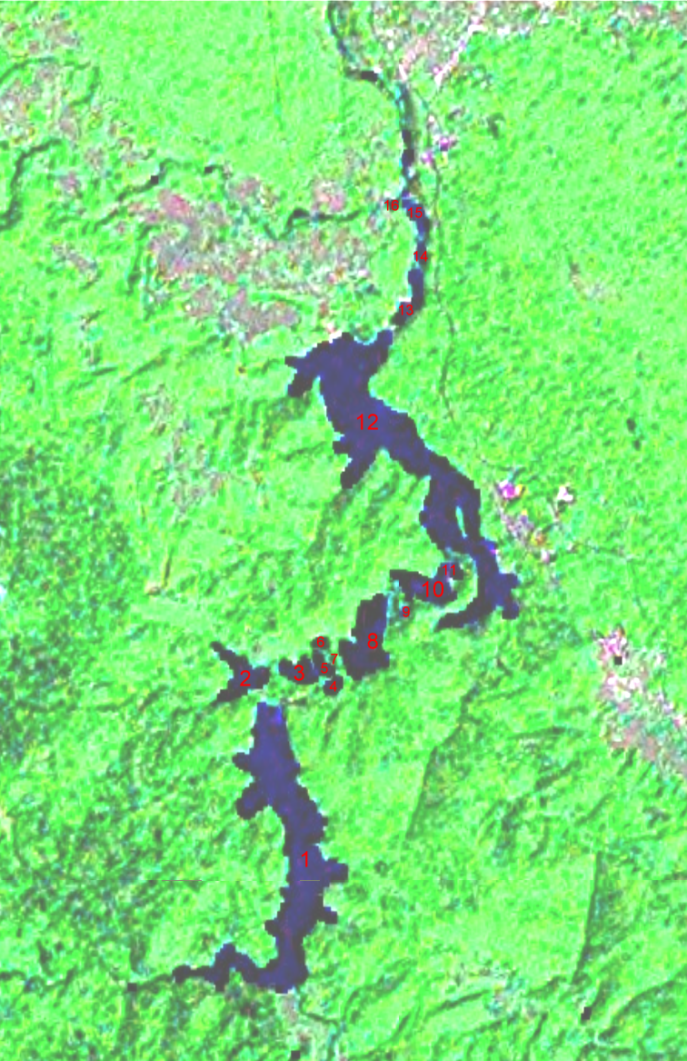 This cool satellite image, while not allowing you to see the drop in elevation of 133 meters from the very large (number 1 on the image) Prošćansko jezero (Lake Proshchansko) at the top to the tiny Novakovića brod (only four tenths of a hectare in area and 5 meters deep) at the bottom of the descent, does let you see some of the park’s extent.
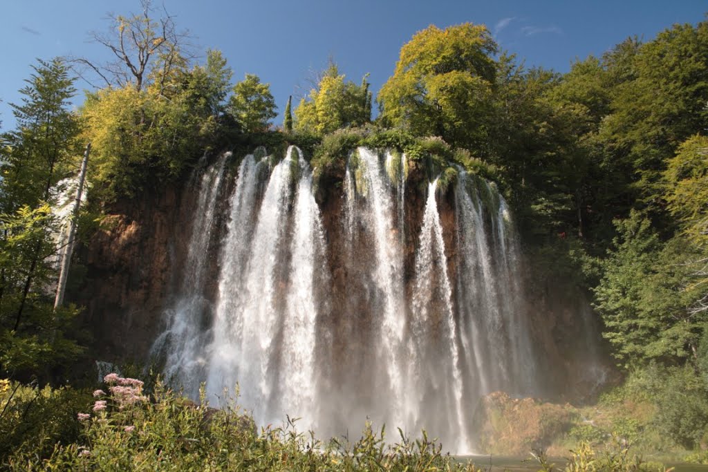
One of the truly unique characteristics of the lakes is that due in part to different depths of water but due more to differences in the mineral content filtering through porous rocks, they present distinctly different shades of water. The change in levels from a higher lake to a lower one is marked by scores (perhaps hundreds) of cascades and waterfalls. The highest waterfalls are the 78-meter Veliki slap (Large Waterfall) at the end of the Lower Lakes (which we didn’t see), over which the Plitvica river falls, and Galovački buk (which we did see)
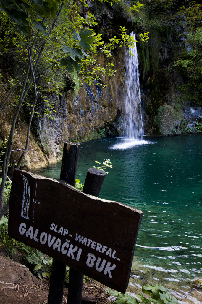
a 25 meter drop visible in the Upper Lakes. Walk past the sign and it reveals a more dramatic view:.
With our tickets already secured, we avoided one line and arrived at a relatively short line at the dock just before the biggest rush of visitors who come in the middle of the day. We took one of the electric boats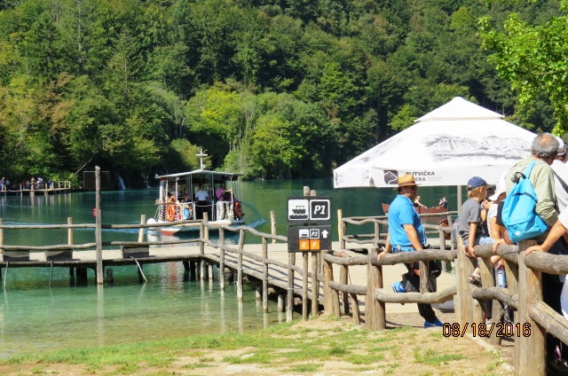
across Lake Kozjak (#12) which is the largest and deepest of the lakes. (No internal combustion propelled boats are permitted in the lakes. Neither is swimming.) The dock is near the cluster of buildings just opposite the lake marked 11 in the satellite view. Once across the lake, our walk took us on a five-kilometer circuit of the upper lakes section. And we’ll start that walk in the next post.
Note: In keeping with my 2022-2023 reformation of the blog into shorter entries, backdated to maintain their sequence, any comments on this post might pertain to its new configuration. See the full explanation in the post Conventions and Conversions.
-

Here are the songs from the México City and México City Olympics posts
May 18, 2026 -

Notes on the XIX Olympiad – the quiet protest – (México City and Me addendum three)
May 18, 2026 -

Notes on the XIX Olympiad – Successes, failures, and a Flop – (México City and Me addendum two)
May 15, 2026 -

Notes on the XIX Olympiad – Understanding Carlos and Smith – (México City and Me addendum one)
May 13, 2026 -

Y no te puedo hallar
May 11, 2026
2 responses to “Falling for Plitvice – part 1”
Dobrze napisane
Dziękuję Ci (This comment and my response are in Polish.) The comment simply says, “Well written” and my response is, “Thank you.”