Badlands, Wall Drug and two carved mountains – part 2 – The Presidents
The second carved mountain.
Mount Rushmore is 16 miles or so northeast from the site of the Crazy Horse Memorial – about a 25-to-35 minute-drive – depending on the vehicles ahead of you once you get onto road 244. Coming from this direction, you see nothing of the sculpture until you actually enter the park, whereas traveling southwest from Rapid City, you can get an interesting view of the presidents from the road.
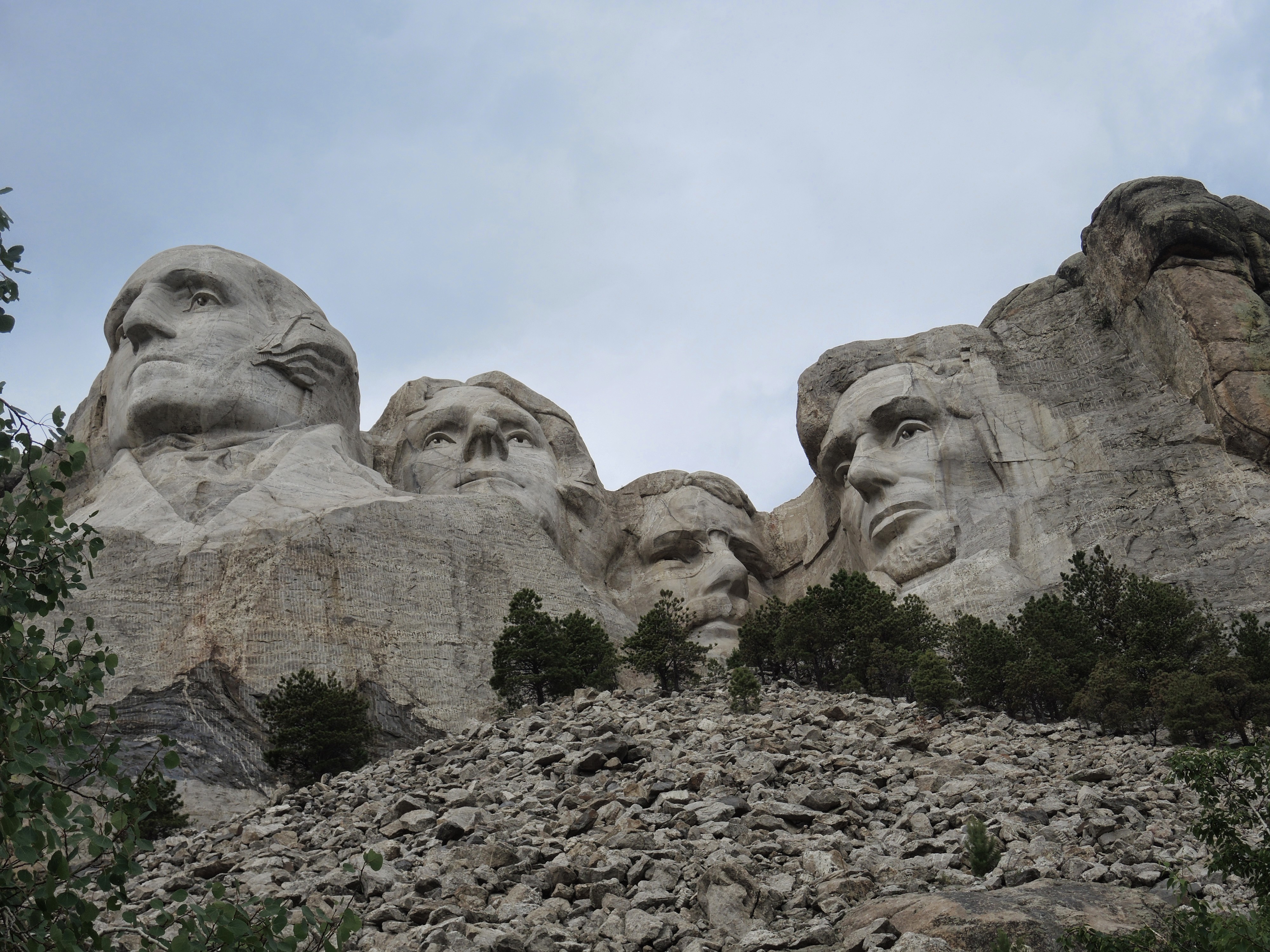
Here are your history lessons about this American icon: The mountain is named for a New York City lawyer – one Charles E Rushmore. Upon the discovery of tin in the Black Hills he was sent by a group of investors to secure rights to the Etta Mine about three miles northeast of the mountain that now bears his name. He wrote that he “was deeply impressed with the Hills, and particularly with a mountain of granite rock that rose above the neighboring peaks.”
One day he was with a group of men and he asked if the peak had a name. They replied that it didn’t. Again, according to Mister Rushmore, “one of them spoke up and said, “We will name it now, and name it Rushmore Peak.” That was the origin of the name it bears.
The genesis of the idea to carve the mountain came from Doane Robinson – a South Dakota state historian who wanted to create a tourist attraction. He wanted it to be of Lewis and Clark, Red Cloud, and Buffalo Bill. However, the sculptor, Gutzon Borglum opted for the four presidents to communicate the founding, expansion, preservation, and unification of the United States.
Borglum had originally worked on Stone Mountain in Georgia where he learned the blasting techniques he would apply to Mt. Rushmore. Though he apparently grew sympathetic to the views of the KKK (which had funded the Stone Mountain work), he left the project over artistic differences after he had completed the head of Robert E Lee.
Work on Mount Rushmore began in 1927 and ceased in 1941. The project was never fully completed as Borglum’s concept was to show all the figures from head to waist. In 1937, Borglum proposed adding Susan B Anthony but could never secure the funding to do so. He died in March 1941 and his son Lincoln oversaw the work’s completion adding the finishing touches before the attraction opened in October of that year.
Sometime in the last 15 years or so, the Park Service has added a trail you can walk to get the very close view of the sculpture you see in the picture. Standing on this observation deck, I saw twin boys of about 7 – Derrick and Evan. I asked them if they had seen the Geico gecko. I told them they had to look in George Washington’s eye. Then I said he was in Lincoln’s nose. This quickly devolved into a typical seven-year-old boy’s discussion about nose excreta that they found particularly amusing.
When (perhaps if) finished, I think the Crazy Horse sculpture will be even more astonishing and more impressive than Mount Rushmore. For me, now, I think I was more impressed with Mt. Rushmore because I could view it as complete and because it’s so iconic that seeing it in person is rather exciting.
Because I prefer interesting rock formations to clusters of trees, the Black Hills you see in my photos is not the best representation of the dense thickly forested mountains that give the area its name. However, looking at them from a distance, in certain light, the density of the trees makes the hills appear black. In addition to Mount Rushmore and the Crazy Horse Memorial, the southern Black Hills region is also home to Harney Peak which, at 7,244 feet, is the highest point in the United States east of the Rocky Mountains.
Now it was time to drive back across South Dakota to Watertown. You can look at this map to get some idea of Monday’s drive.
I started in Murdo which is near the junction of U S 83 and I-90 (about halfway between Chamberlain and Wall. I drove west through the Badlands then to Rapid City and the two mountain carvings then back east to Watertown which you can find if you look north of Sioux Falls on I-29. Because I chose to stay on the interstates, I probably drove about 20 or 30 miles further than I would have had I followed U S 14 but, for this day, time was the governing factor in my route choice.
As I drove along the prairie, I could only envision it in winter. Cold, snow covered, and bleak with nothing around you for miles and miles other than more miles and miles. It’s easy to be deceived by how lovely the land is at the height of summer when you are surrounded by the wide dome of sky, the green of new growth, and acres of wildflowers. Though you sense the sparseness of the country you are also engulfed in its beauty. For me, however, I think that summer beauty would turn to desolation in winter. This hit home even more as I drove north on I-29. Driving scores of miles, I rolled along past houses, farms and fields. Even at most interchanges there was no development – no gas stations, motels, or stores. The road didn’t even have the profusion of billboards of I-90 advertising one South Dakota attraction after another.
When I reached Watertown late Monday night, the first time I reached a stop in darkness, I had driven over 2,000 miles since Saturday. This should constitute about a third of the total of this journey. Interestingly, I was far enough north that looking to the northwest and its wide, unobstructed views there were still traces of dusk even as late as 22:00.
Tomorrow, the spaces become notably smaller.
-

Here are the songs from the México City and México City Olympics posts
May 18, 2026 -

Notes on the XIX Olympiad – the quiet protest – (México City and Me addendum three)
May 18, 2026 -

Notes on the XIX Olympiad – Successes, failures, and a Flop – (México City and Me addendum two)
May 15, 2026 -

Notes on the XIX Olympiad – Understanding Carlos and Smith – (México City and Me addendum one)
May 13, 2026 -

Y no te puedo hallar
May 11, 2026