In deference to those who prefer skipping these little lessons in geology, I’ve decided to make it a stand alone post rather than integrating it into the day’s activities. I write these posts because, for me, my appreciation of anything generally increases in at least a linear manner that parallels my understanding. Learning music theory helps me understand what makes certain music great. Knowing the rules and strategies of a sport elevates my enjoyment of the competition and so on. With that in mind, let’s take a look at the coastline of the Algarve and the forces that have made it so beautiful.
West to East.
Starting in Sagres which is more or less the western tip of the Algarve it’s a mere 150 kilometers or so to drive to Vila Nova de Cacela the last civil parish in Portugal. Continue east from there for only another 20 km and you will cross the border into Spain. (For some U S comparisons, this full spread is about the same distance as Washington, DC to Wilmington, Delaware; a little longer than the distance between Chicago and Milwaukee, and a little less than from San Francisco to Monterey, or from London to Dover for my friends in the UK.)
Those of you who read the previous post or looked at the photos of Sagres know that the Algarve’s west coast beaches look like this.
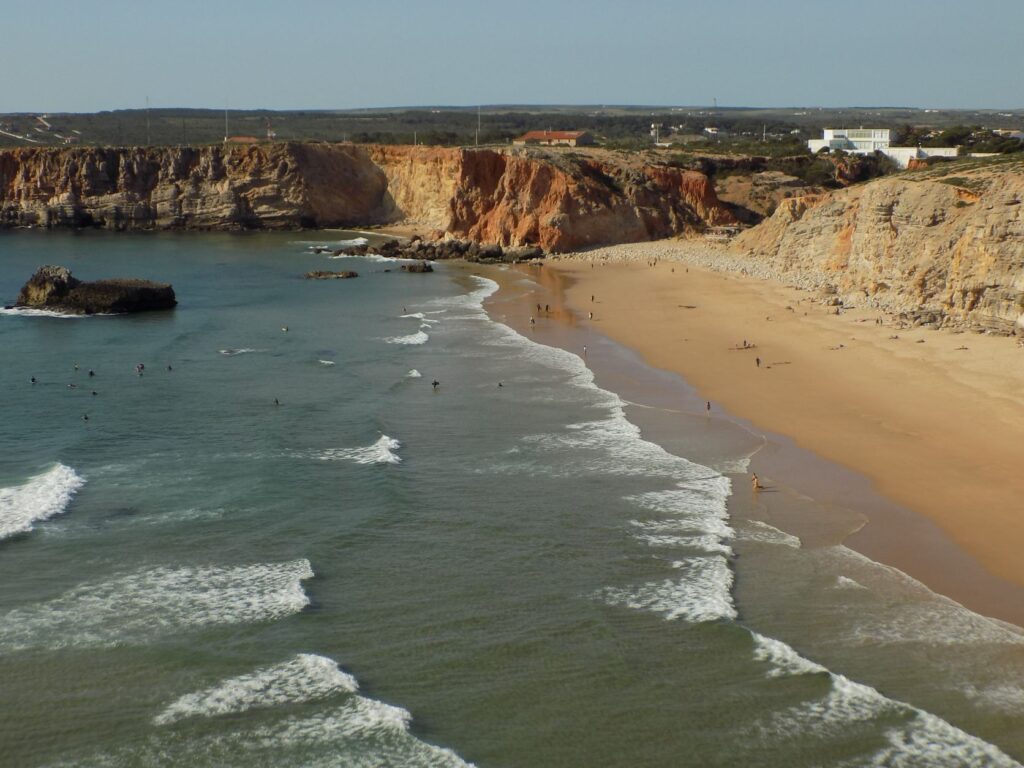
Move east to Salema (another charming town that I liked but that also felt a bit small and isolated) and you can find long stretches of accessible sandy beaches. A little farther east – just 30 kilometers from Sagres – you reach Lagos where you can find some sandy beaches but only a few that are easily accessible. Almost all of them abound with seemingly otherworldly formations.
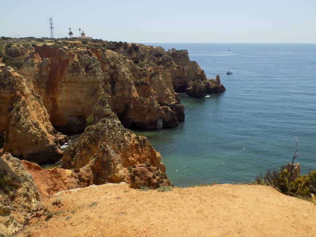
Continue on to Tavira the largest town in the Algarve’s east and you’ll find the closest beaches are more like sandbars. For this post, I’m going to focus on the section with those dramatic cliffs that are comprised of layers of different types of rocks deposited over tens of millions of years.
I’m getting sedimentary over you.
Those of you who have read the “time before humans” posts in my Olympic cities series should have a reasonable basis for the terminology you’ll encounter herein. For those who haven’t, I’ll warn you in advance that I’m not going to define terms unless they’re new.
About 100 million years ago (M Y A), continental Europe looked nothing like it does today.
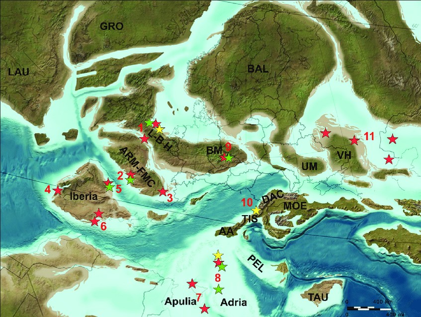
[Illustrative map from Researchgate uploaded by Zoltan Csiki-Sava.]
Iberia was essentially an island that hadn’t yet fused with the mainland and the part of the peninsula that would become Portugal had a nearly east-west orientation versus its current north-south alignment. (It’s marked above by the number four.) As Iberia approached the other segments of Europe, it rotated counter clockwise opening space for the Atlantic Ocean to flow into the Mediterranean and creating greater separation between it and both North America and Africa. Even though they hadn’t yet joined, by the late Cretaceous some 70 M Y A, events in other parts of Europe – that I’ll return to below – would impact the geology of Iberia.
If we had an orbital view of Earth from the late Miocene Epoch (about 5M Y A), the southwestern corner of Europe would now look reasonably familiar. It required a combination of tectonic movement and volcanism over that 95 million year period beginning with the first map above in the Upper Cretaceous to create Portugal’s dramatic southern coast – the area geologists would call the Algarve Basin.
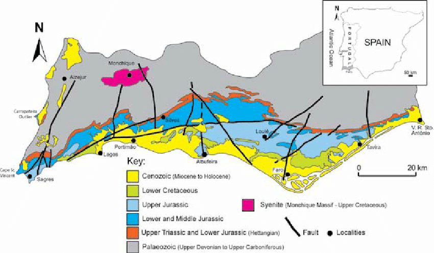
[Illustrative map from Researchgate uploaded by Jose Tomas Oliveira.]
Let’s first take a WABAC ride to the early Jurassic when a particularly active period of volcanism associated with the Central Atlantic Magmatic Province (CAMP) laid magma rocks over the existing upper Triassic strata. This activity was followed by a substantial period of marine carbonite sedimentation. The dominant lithofacies from this time are shallow water limestones and marls that sank slowly through the ocean water. (Lithofacies are a mappable subdivision of a volume of rock of identifiable origin defined by distinctive, easily mapped, and recognizable petrographic or lithologic characteristics that can be distinguished by its facies or its lithology {stratigraphic unit.} This is the texture, mineralogy, grain size, and the depositional environment that produced it.)
Moving forward from the Jurassic into the early Cretaceous, we begin to see a mix of clastic (mudstone and sandstone – deposited fragments of eroded rocks and minerals) and carbonate deposition both inland and in the coastal areas. Everything looks to be progressing in a direct temporal line as we watch this orderly sequential deposition and layering of rocks. But then there’s a gap. About 65 or 70 million years ago, sedimentation seems to have stopped. No matter how closely we look, late Cretaceous rock strata are absent from the Algarve Basin.
This is when the “events in other parts of Europe” I mentioned above come into play. At about the same time as that meteor was causing a mass extinction event (give or take five million years), the Earth decided to begin lifting up a new set of mountains we call the Alps. The intraplate, relaxational response to forces developed during the rapid reconfigurations of the Alpine-Tethys (Europe-Africa) convergent plate boundary throughout this orogeny prompted the inversion of sedimentary basins all across Europe including Iberia and the Algarve. Some of the best evidence for this comes from the deposition of syenite (a coarse grained intrusive igneous granite-like rock that lacks compositional quartz) in the mountainous area called Monchique roughly 30 km inland from the west central Algarve.
Interestingly, at Ponta da Piedade – just a few kilometers walk from my hotel –
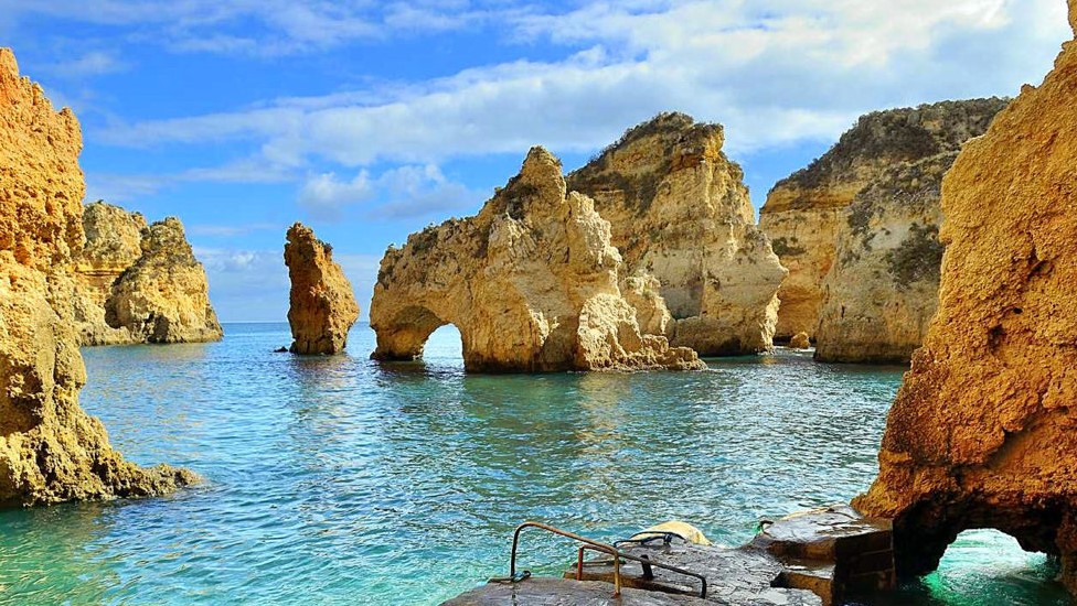
we can see the youngest sedimentary rocks of the basin. Ninety percent of these rocks are fossils cemented together by calcite cement (biogenic carbonate in shallow marine sandstones). The geomorphological features of the cliffs in this area provide evidence of excessive erosion and sediment karstification.
Now, when you visit the Algarve and admire the stunning coastline, you’ll know that you are looking at 90 million years of geologic history involving volcanism, sedimentation, inversion, and plate tectonics as well. Or maybe you’ll just think, “Wow! That’s beautiful.”
Leave a Reply