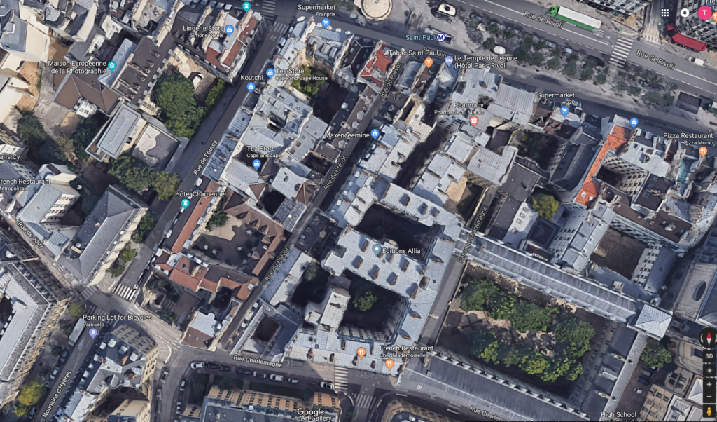
In a previous post I included a map that showed the location of our flat and pointed out our proximity to many Parisian sites. I wrote about the veritable cornucopia of specialty shops lining the rue de Rivoli and mentioned that we had “the Métro almost right outside our door.” Now, I want you to look at this satellite image from Google.
Even without enlarging the image, you should be able to see the two orange symbols near the bottom. Our flat was essentially on the fourth floor between those two symbols and you can clearly see the two main courtyards of the building. What you can’t see as clearly is that beyond the second courtyard the passage continues to the main street visible in the top right and that is the rue de Rivoli. If you enlarge the photo, you’ll see a marker for the Pharmacie du Marais and the passage from our building continues just to its right from this viewpoint. You’ll also see the Métro entrance identified just to the right of the round building at the top center.
So, if we wanted to walk south toward the Seine, we would exit onto rue de Charlemagne but if we wanted the Métro or shopping, we’d go out the gate onto rue de Rivoli. (Okay, technically we exited onto rue Saint-Antoine but even Celeste called it Rivoli and rue Saint-Antoine hardly felt like a street – at least until you heard the impatient beep of a car or bus horn as a reminder.)
All around the arrondissement.
We’d returned from the cruise at mid-morning Thursday and had four more full days and nights before our respective Tuesday departures – Pat’s early in the morning and mine a bit after noon. Friday was the only day for which we had any specific plan and it was a plan we’d begun months before. When I finished reading David Downie’s book about Paris, the brief biographical blurb on the last page noted that he had a website for walking tours. I suggested to Pat that we should at least explore hiring him for a guided tour. She agreed and we did just that. (Our timing was fortunate because David had hinted that he was planning a break for the summer while he finished work on his novel and that he was winding down his guide services.)
We decided to have a full day tour spending the morning exploring le Marais and the afternoon at another of David’s favorite haunts – and a place that was among my Paris must sees – Père Lachaise Cemetery. We met a mildly unhappy David waiting for us on rue Charlemagne at 09:00. I’ll explain.
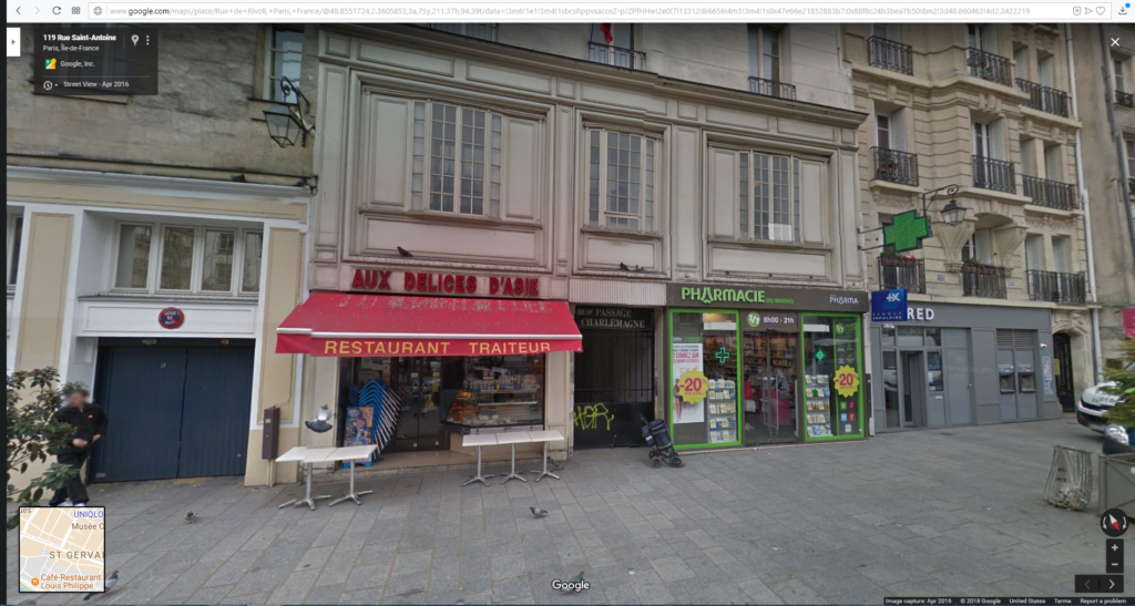
David chafes a bit at the coded entry needed to enter the premises from both the Charlemagne and Rivoli sides. You see, David has lived in the Marais since sometime in the 1980’s and, at that time, this was a public passage. (In fact, it’s clearly marked above the gate on the Rivoli side – Passage de Charlemagne which you can see if you enlarge the Google Street View.
These interiors always interested David and ours had an old bookstore, a design studio, and another shop of some sort. One result of the area’s gentrification, however, has been the installation of these coded entries thereby making private what had once been public spaces. David finds them nettlesome. (By the way, the traiteur is a carryout restaurant.)
We had a pleasant surprise as David’s wife, the photographer Alison Harris, had decided to join us for the day. We had a sense of the value David would add to our day within seconds of our introductions. (Because I, too, try to add value when I write these posts, I’m not going to adhere to a linear chronology. This entry will cover some of the highlights of our morning walk and end with our dinner. I judged two of the places we visited in the morning as meriting their own posts as did our afternoon at Père Lachaise.)
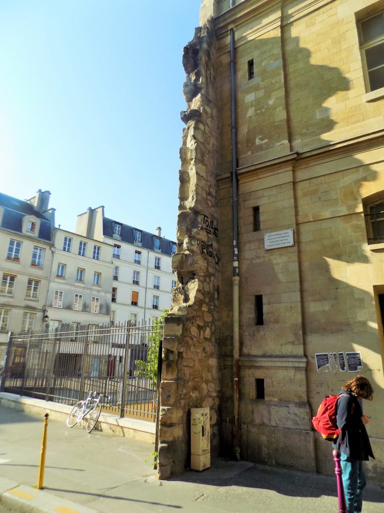
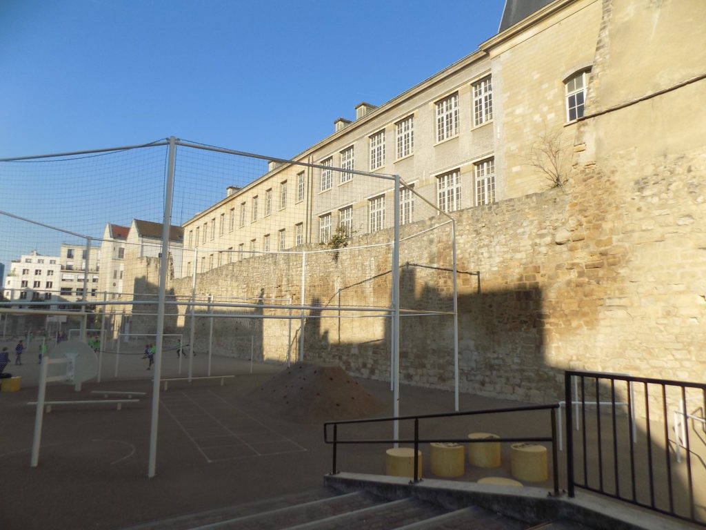
In front of us was a jagged stone wall that Pat and I had walked past without noticing on our way to dinner last night. It jutted onto the sidewalk like an inverted leg of a pair of tapered pants – wide at the bottom and narrow at the top – daring a student from one of the nearby schools to scale its lower section that was perhaps a bit more than two meters high and tag it with some graffiti. Apparently, at least one person had accepted the challenge.
But this is no mere remnant of a random stone wall.
The wall of the first King of France.
When I wrote about Honfleur, I mentioned that Philippe II (also known as Philippe Auguste) was the first monarch to call himself King of France rather than King of the Franks. This is not a distinction without a difference. One claims to rule over people while the other asserts its rule over territory. Philippe II ruled France from 18 September 1180 until his death on (presciently?) 14 July 1223.
(You might read that Philippe had his coronation on 1 November 1179 and wonder why I mark the beginning of his rule nearly a year later. The customary practice of the Capetian kings was to crown their heirs apparent while they were still alive, thereby averting any succession disputes. With his health declining, a 59 year old Louis VII crowned his 14 year old son Philippe on 1 November 1179 conferring upon him the title Junior King.
Generally, the junior king had no real authority but his ascent to the throne was guaranteed upon the death of the ruling monarch. However, with his father showing signs of dementia and an advantageous marriage in April 1180 to Isabelle of Hainaut, Philippe began exercising his authority almost immediately.)
Philippe was an ambitious and rather bellicose monarch. In 1181 he began a war with another Philippe – Philippe, Count of Flanders who had given the county of Artois to his niece Isabelle as her dowry when she married Philippe. That war lasted until the Treaty of Boves was signed in 1185 and it significantly increased the territory under Philippe’s rule.
Meanwhile, in 1183, Philippe had also begun a war with Henry II of England. This one centered on a monarchical dispute over control of the duchy of Burgundy. Philippe’s sister Alys was betrothed to Henry’s son Richard. Richard, who would eventually be known as Richard I (the Lionheart) initially sided with Philippe against his father Henry.
In 1189, Philippe and Richard joined with other European kings on the Third or King’s Crusade. Before leaving on the Third Crusade, Philippe ordered the construction of a defensive wall to protect Paris during his absence. Construction of the wall began on the Rive Droite in 1190 and required nearly two decades to complete. Work on the Rive Gauche section began in 1200 and was completed in 1215.
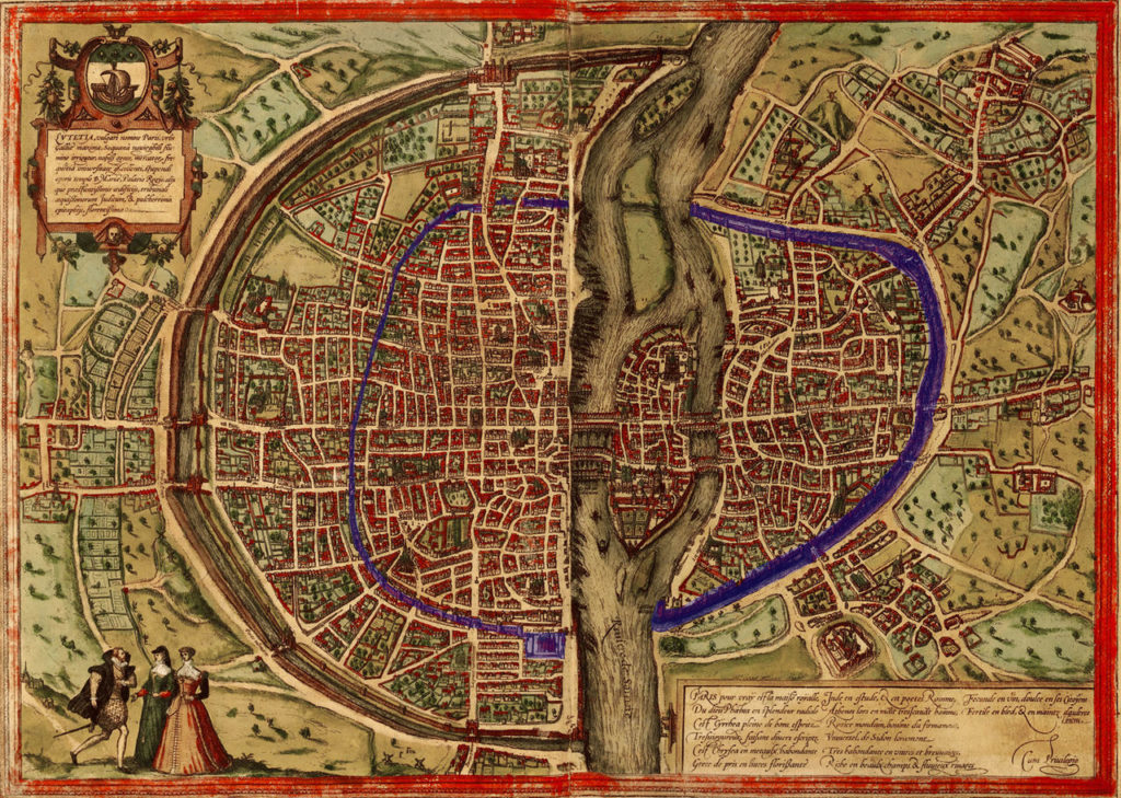
This map (from Wikipedia) drawn by Sebastian Münster in 1572 shows Philippe’s wall in blue. The section of the wall we were looking at on rue Charlemagne is, in fact, part of the longest remaining section of the wall – as we would see when we walked to its other side.
(To find our approximate location on Münster’s map, find the two unoccupied islands [Île Notre Dame and Île aux Vaches its smaller counterpart to the east that were joined in 1614 to become the present day Île Saint-Louis] and look north. {The map’s orientation has west at the bottom and east at the top.} The section of wall we’re looking at is likely the longer section north of the river.)
Until David pointed it out, Pat and I had no idea we had more than eight centuries of history mere meters from our door.
Note: In keeping with my 2022-2023 reformation of the blog into shorter entries, backdated to maintain their sequence, any comments on this post might pertain to its new configuration. See the full explanation in the post Conventions and Conversions.
Yes it was a very pleasant-potentially life-saving (not saying whose life/lives) – surprise to be joined by Alison. Her photographer’s eye and longevity in the city she also loves make her an excellent guide without those let’s say “distracting” pun barrages. You are the cemetery guy, but Pere Lachise with the Downies is the best.
👏👍💯
And I will have a lot to say about Pere Lachaise after two more posts about the morning in le Marais.