Salt Lake City in the time before humans (Salt Lake City and Me supplement two)
Recently, I was talking with someone about this Olympic host cities project and he expressed surprise that Salt Lake City had hosted a Winter Olympics because his impression of the city was that it’s relatively flat. He isn’t wrong. SLC lies in a valley between the Oquirrh Mountains on its west and the Wasatch Mountains to the east. (This shouldn’t come as a great surprise, either. As you might recall from the post about Sarajevo’s geography, valleys are the most common landform on Earth.) On the other hand, Park City which is home to several noted ski resorts is less than forty miles from downtown SLC and that’s where the athletes and spectators had to travel for the Alpine skiing, freestyle skiing, and snowboarding competitions. So, let’s take a look at some of the forces that shaped the region.
We’re doing physiography.
Even if you’ve been plowing through all the geology in this blog, I think this is the first time you will have encountered the term physiography. The simple way to think of physiography is as physical geography. The precise definition of a physiographic region is “an area with a particular pattern of relief features or land forms with a characteristic geomorphology, and often specific subsurface rock type or structural elements that differ significantly from that of adjacent regions.” The United States is comprised of eight physiographic regions that can be divided into 25 physiographic provinces which, in turn can be further divided into 85 sections.
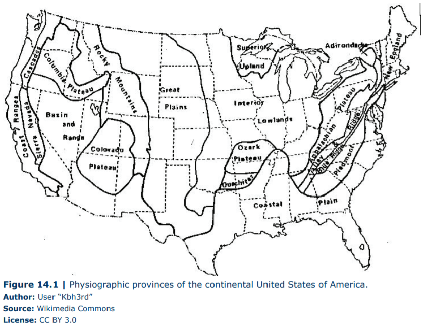
[Physiographic map from geo.libretexts.]
Looking at the map, you can see that the Basin and Range covers a substantial part of the southwestern U S and SLC in is a section of the province called the Great Basin. The topography of the Basin and Range Province is characterized by steep, narrow, north-south trending (or south-north depending on your perspective) fault-tilted mountain ranges such as the Wasatch that are separated by wide, flat, sediment-filled valleys. The mountain ranges are slowly shedding sedimentary rocks that are filling the wide flat basins. Lakes such as Lake Bonneville that have intermittently covered the valley floors have also deposited sediments that have modified and reshaped the basins.
I’ve introduced this concept now because while SLC is in the Basin and Range Province, the broader area sits essentially at the junction of three physiographic provinces – the Basin and Range, the Colorado Plateau, and the Middle Rocky Mountains. This characteristic contributed to creating and coalescing many of the elements that allowed it to be such a suitable host for the Winter Games.
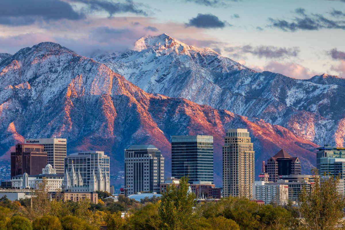
[Photo from visitutah by JayDashPhotography.]
Wasatch you say?
The province nearest SLC is the Middle Rocky Mountain Province and it’s here that we find the Wasatch Mountains (also the Teton, Absaroka, Bighorn, and Wind River chains). At their core, the Wasatch Mountains are extremely old. Some of its rocks date to the pre-Cambrian with an age of 2,600,000,000 years but that have been altered by multiple cycles of orogeny, erosion, and other forms of destruction and burial.
However, the mountains we see in the photo above are relatively young. The uplift of the current Wasatch range began a mere 17 million years ago. But there’s a lot more to the region than what happened in the past 17 million years so, after some time in the shop for a tune-up, it’s time to fire up the old WABAC and take a look at the North American west in the Mesozoic so we’ll be buzzing back about 165 million years to the late Jurassic and into the Cretaceous Period.
At this time. the continent that would become North America probably looked something like this:.
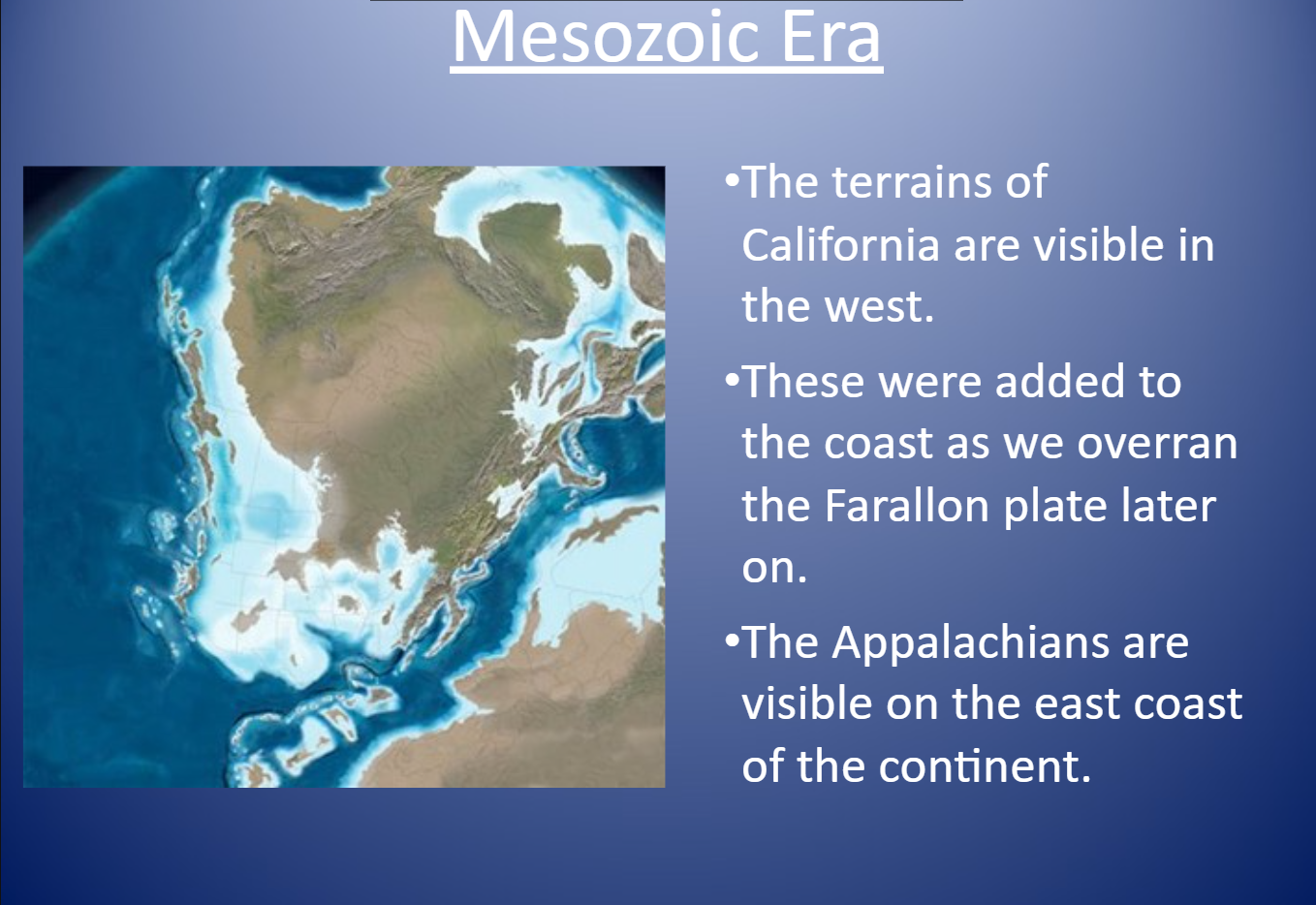
[Image from slideshow.com.]
Note that the land that eventually became California is separated from the main land mass by a continental shelf covered with shallow, warm sea water. At around this time, the North American Plate, which had been moving toward the east shifted directions and began making its move on the Pacific plate to its west. But, if you recall from the Los Angeles geological addendum, the Farallon plate stood between them. Because the Farallon was the heavier of the two plates, about 30 M Y A it began subducting the North American plate. This process initiated the Laramide orogeny which gave rise to the Rocky Mountains.
The Wasatch were once considered part of the Rocky Mountains and few, if any, geologists would classify them otherwise at the time of the Laramide and Sevier orogenies. However, some debate now exists because the processes that gave rise to the Wasatch as we see them – normal faulting and pull apart tectonics – are more typical of the Basin and Range physiography than they are of the deformational compressive uplifts that characterize the Rockies. While I’m going to side with the Basin and Range folks, it may be best in the end to view the Wasatch as a transitional zone.
The shrinking Wasatch is not the fault’s fault.
Geologically speaking, western North America was a busy and active place throughout the Cretaceous period and deep into the Cenozoic era. From the late Mesozoic to the beginning of the Cenozoic, compressional forces in the earth’s crust formed mountains by thrusting up large sheets of rock in the two above mentioned orogenies. Over a period of 30 million years or so, erosional forces in Utah wore down this thrust belt.
But things were heating up as the plates continued their dirty dancing. All of this activity created hot spots about 38 to 24 million years ago. Hot spots lead to volcanoes and volcanoes push large bodies of magma to the surface. In this instance, the magma intruded parts of what is now the Wasatch Range. These intrusions, eroded thrust sheets, and the older sedimentary rocks are what comprise the uplifted Wasatch Range as it is seen today.
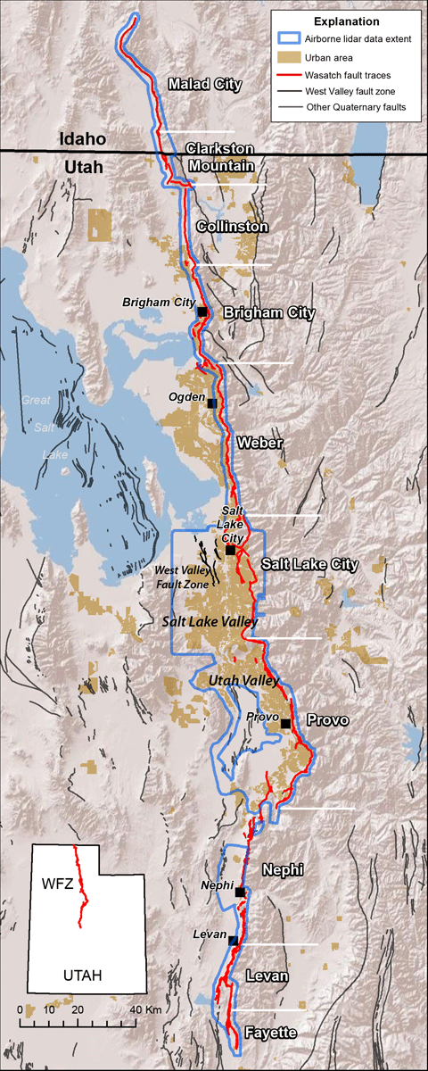
[Map from geology.utah.gov.]
All geological faults lie at some sort of tectonic boundary or margin. As you look at the map of the Wasatch fault above, the boundary is a relatively stable North American plate on the east side with the stretching and sinking crustal segment of the Basin and Range on the west. The Wasatch is a normal fault. At a normal fault, blocks of rock shift vertically and the rock mass above the fault moves down. Like so:.
It’s the movement along this fault that began about 17 million years ago that lifted up today’s Wasatch Mountains.
While movement along the fault has been the principal driver lifting the mountains, other forces have contributed to shaping them. Explore the range and you’ll encounter smooth U-shaped valleys shaped by glaciers. In other spots you’ll see V-shaped valleys cut by rivers flowing into prehistoric Lake Bonneville and what remains of it – the Great Salt Lake.
Erosion by wind, rain, snow, hail, and occasionally avalanches has not only sculpted the rock, stripped it off the surface, and worn it down to dirt but has done so at a pace that outstrips the uplift activity of the still active fault which averages about 1 mm of vertical displacement annually. (The most recent noteworthy tectonic activity was the 5.7 magnitude earthquake in SLC on 18 March 2020.) Even so, the Wasatch are gradually shrinking.
-

Here are the songs from the México City and México City Olympics posts
May 18, 2026 -

Notes on the XIX Olympiad – the quiet protest – (México City and Me addendum three)
May 18, 2026 -

Notes on the XIX Olympiad – Successes, failures, and a Flop – (México City and Me addendum two)
May 15, 2026 -

Notes on the XIX Olympiad – Understanding Carlos and Smith – (México City and Me addendum one)
May 13, 2026 -

Y no te puedo hallar
May 11, 2026