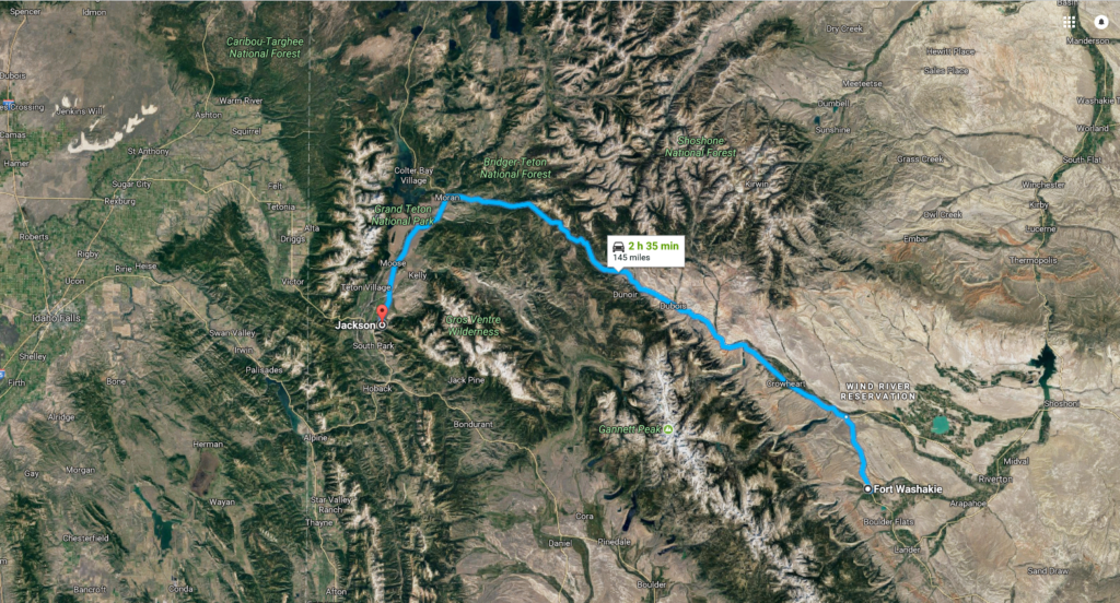
My report on the Tetons will be among the shortest posts of this trip. As shown on the map below, the remainder of the drive from Fort Washakie to Jackson follows a straightforward route – essentially Route 287 to left on Route 26. However, I’ve included the map not simply to trace my drive but to provide a reminder of the stark difference between the land on the Wind River Reservation and the land off it.
Perhaps my judgment on the quality and beauty of the land is rash. It’s certainly not thorough. Remember, the Wind River Reservation is huge. At 2,200,000 acres it’s about as large as Yellowstone National Park, the eighth largest American Indian reservation, and larger than both Delaware and Rhode Island. My drive across this reservation was admittedly limited. I entered from the southeast, made a single stop, and confined my transit to a small strip of land near the southern boundary of this territory set aside for the Eastern Shoshone and Northern Arapaho tribes.
It’s possible that there are areas on the reservation that are breathtaking. However, that isn’t particularly consonant with my experience of southern Wyoming, my (albeit limited) knowledge of the U S government’s relationship with and treatment of the land’s first peoples, and the type of land generally ceded by the government for reservations, or the look of the satellite photo below – that appears to show Wind River Reservation as relatively flat prairie with a few narrow strips of arable land.
If you enlarge the map, the town of Crowheart is on the reservation and the town of Dubois is not. None of the mountainous green area is part of Wind River and one of the notes I dictated into my recorder as I drove along supports the notion that there’s a stark contrast in the scenery between most of southern Wyoming and the approach to the Tetons.
Uplift, drift and convection.
Although the sky was surprisingly clear while I was at Fort Washakie, it wouldn’t remain so as I continued westward toward Jackson and Grand Teton National Park. Let me settle one point early in this section. According to the website jacksonhole.net, “Jackson Hole commonly refers to the entire valley beginning six miles south of Yellowstone National Park following the Snake River south to Hoback Jct. Our valley is 80 miles long and 15 miles wide. “Jackson” commonly refers to the main town or downtown area of the valley.”
Jackson is where I’ll spend the next two nights while traveling through the park and valley. My plan was to explore Grand Teton National Park and Jackson Hole the afternoon of 2 September, all day on the third and, perhaps, the morning of the fourth. However, those plans would change for reasons explained by Jerome Kern and Otto Harbach:.
But I can’t allow a little smoke to cut short a good geology lesson so let’s take a look at the formation of the Grand Tetons.
The Teton range is something of a study in contrasts. It’s one of the youngest mountain ranges in North America and the youngest of the various ranges of the Rocky Mountains. At the same time, the area consists of some of the oldest rocks on the continent.
The Tetons are a fault block mountain range. This is a type of mountain range that has been carved from a segment of the earth’s crust and uplifted along a fault. A mere six to nine million years ago movement along the Teton fault stretched and thinned two blocks of the earth’s crust. The fault’s west block rose to form the Teton range while its east block fell forming the valley called Jackson Hole.
Rolling through the rocks, however, we find that the geological processes that led to the current composition of the oldest rocks in the Teton range began about 2,500,000,000 years ago. At that time, sand and volcanic debris settled into an ancient ocean. Additional sediment was deposited for millions of years and eventually heat and pressure metamorphosed the sediment into gneiss. (Geology.com defines gneiss as, “a foliated metamorphic rock identified by its bands and lenses of varying composition, while other bands contain granular minerals with an interlocking texture. Other bands contain platy or elongate minerals with evidence of preferred orientation. It is this banded appearance and texture – rather than composition – that define a gneiss.”)
Subsequently, magma was forced up through the cracks in the gneiss to form granite, anywhere from inches to hundreds of feet thick.
During the Cambrian period (541-485 million years ago), deep deposits of sedimentary rock were deposited in shallow seas over the metamorphic basement rocks. Erosion and uplift have exposed the metamorphic and intrusive igneous rocks that are now visible on the east slope of the range as well as in the Cathedral Group and the Paleozoic and Cenozoic sedimentary rocks on the west slope. Later Paleozoic rocks were deposited in warm shallow seas while Mesozoic (250 m y a) deposition transitioned back and forth from marine to non-marine sediments with the Cretaceous Seaway (not to be confused with the Western Interior Seaway discussed elsewhere) periodically covering the area late in that era.
Note: In keeping with my 2022-2023 reformation of the blog into shorter entries, backdated to maintain their sequence, any comments on this post might pertain to its new configuration. See the full explanation in the post Conventions and Conversions.

Okay you got me with short and music which I love to sing alongside alongside the with in the privacy of my living room–and of course the-ahem-tetons story.
Have hardly been able to do much print reading over the past few weeks. Been listening to audiobooks and podcasts and watching PBS and my sports teams until what we will call my eye strain is gone.
Any hook that works!