Double Dutch – part 1
It was past noon when we finished our tour of Monument Valley. Or, I should say, I was reasonably certain that the time on my cell phone showing it as past noon was correct since both the Navajo Nation and Utah switch to daylight saving time and I was in one of those places. Since it was lunch time, I went up to the Visitor’s Center and The View Hotel. The line was long and the restaurant’s menu didn’t impress me enough to wait so I decided to head back to Kayenta and get started on my way to Kanab. It might seem counterintuitive since Kanab, like Monument Valley, is in Utah but traveling back into Arizona is the only reasonable way to drive there from Tse Bii’ Ndzisgaii.
(By the way, although it’s a bit pricey, you should consider staying at The View if you plan to visit Monument Valley. Every room has a private balcony and a view of some of the park’s iconic formations so I’d think it well worth any added expense. I missed it because, once again, my search for area hotels was too casual.)
However, before I made that turn back south, on Albert’s advice, I turned right and drove a few miles north. Here’s why:.
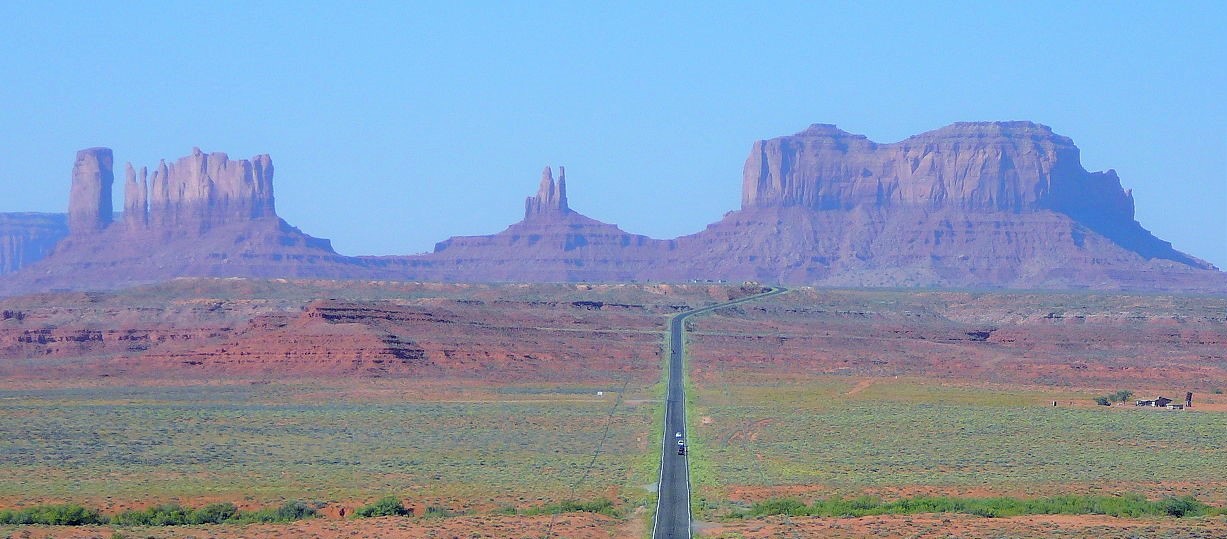
That view (and it’s one fans of Forrest Gump should recognize) strikes me as well worth the 10- or 15-minute delay it added to the trip before I could eat lunch.
I decided to try the Blue Coffee Pot in Kayenta. Red meat dominated the menu so I had a perfectly ordinary chicken sandwich and fries but at least felt some satisfaction in supporting a local business.
Bryce yourselves – Can you handle the truth?
On my way to Kanab, the route took me through Page, Arizona where I thought about stopping by the Powell Museum (you remember John Wesley Powell, I hope) but the drive to Kanab was a bit longer than three hours and, given where I was staying, (I’ll have more to write about that in a subsequent entry.) I thought it best to check-in before driving on another hour or more to reach Bryce Canyon.
(I will say that if I ever return to this area – even if I’m in Las Vegas which is four or five hours drive distant – I’d think about driving up to Page because of some exceptionally beautiful nearby sites such as Antelope Canyon and Horseshoe Bend.)
Here’s the truth about Bryce Canyon. It’s not a canyon! That’s right. Simply calling a place a canyon doesn’t necessarily make it a canyon and, a bit later, I’ll reveal how it came to be called Bryce Canyon.
Thus far on this trip we (that is you, the reader, and I and not the “royal” we) have visited three real canyons – Grand, Walnut, and de Chelly and I’ve written about the principal forces of uplift and erosion that shape them. While wind can play a role as an erosive force and sedimentation can play a shaping role of its own, the first commonality to all canyons is erosion initiated from a central stream – the Colorado River for the Grand Canyon, Walnut Creek for Walnut Canyon, and so on. This isn’t what happened at Bryce so technically, it’s not a canyon (although, since canyon is part of the park’s official name, I’ll use it, too, for commonality of reference). Bryce is actually a collection of giant natural amphitheaters along the eastern side of the Paunsaugunt Plateau. Since strictly speaking, it’s not a canyon let’s take a look at how these amphitheaters came to be.
We’ve already established (I think) that the uplift of the Colorado Plateau began some 80 million years ago in the late Cretaceous Period of the Mesozoic Era. It continued at a consistent rate for 30 million years into the Paleogene Period of the early Cenozoic Era before it paused for 15 million years. The process recommenced about 35 million years ago but at a rate more than double the initial expansion. It’s this second period that created the Paunsaugunt Plateau between 10 and 20 million years ago.
This relatively rapid second period of uplift caused joints to form along the side of the plateau. In geology, a joint is “a break of natural origin in the continuity of either a layer or body of rock that lacks any visible or measurable movement parallel to the surface (plane) of the fracture.”
Subsequently, a process called headward erosion (“the process by which a river erodes its source region, seemingly lengthening its channel in a direction opposite to that of flow”) took place, especially along the eastern side of what is now Bryce Canyon National Park, that excavated large amphitheater-shaped features. A series of amphitheaters extends more than 20 miles north-to-south (or south to north if you prefer) within the park. The largest of these is the 12 mile long and three-mile-wide Bryce Amphitheater that reaches a depth of 800 feet.
Subsequent erosion within the amphitheaters created the signature features for which Bryce is known – the colorful and delicate looking formations called hoodoos. (What a great word! No?)
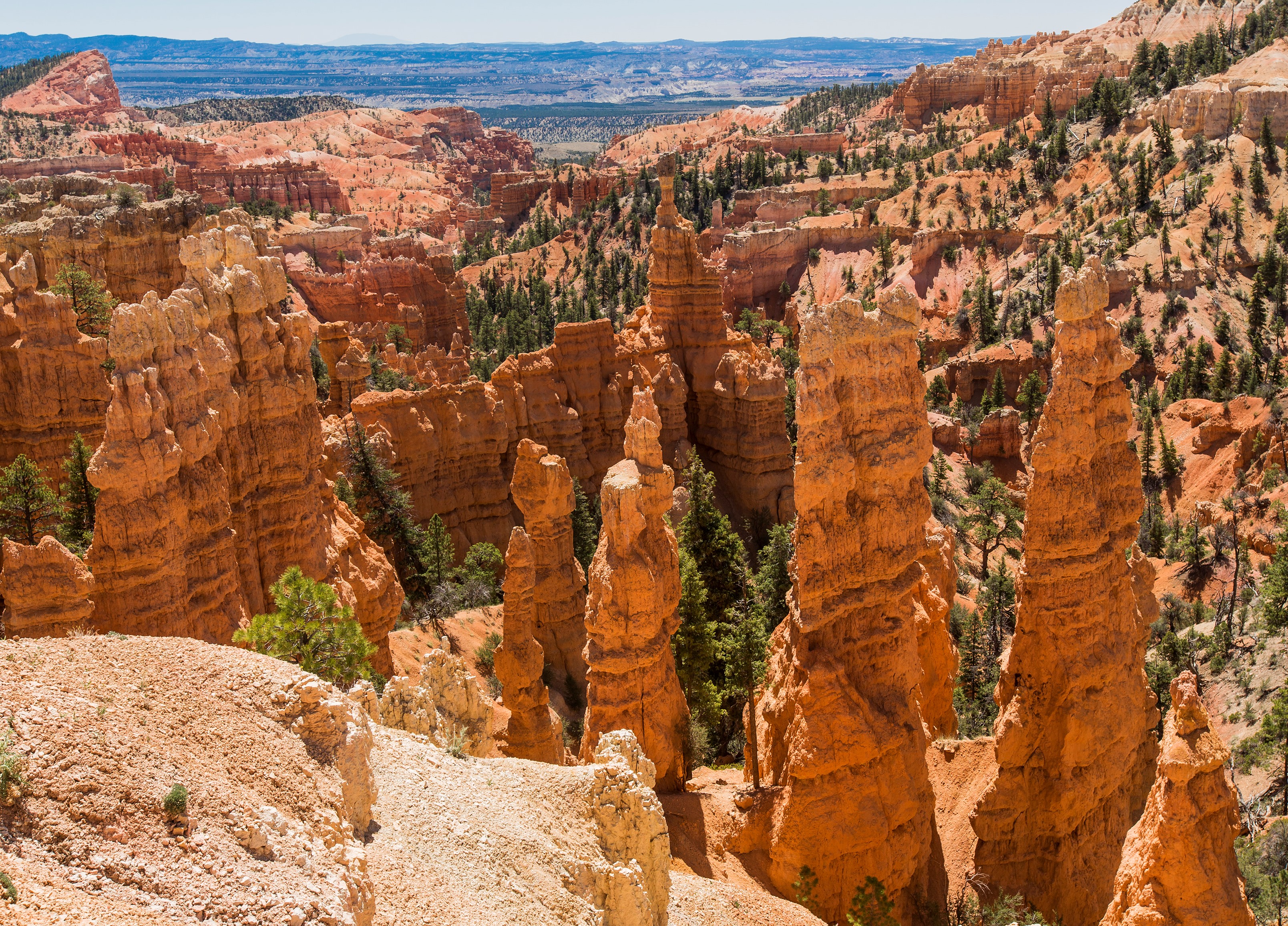
Now, I’m going to tell you about hoodoos. (You really didn’t think you were going to escape without a description of what hoodoos are and how they form, did you?) Sometimes called a tent rock or a fairy chimney, a hoodoo is a tall, thin spire of rock that protrudes from the bottom of an arid drainage basin or badland and that may range from five feet to 200 feet tall.
(The photo above is at a spot called Fairyland Point and was my first encounter with the hoodoos of Bryce. I’d have certainly missed it had one of the folks at Best Friends Animal Society not told me about it when I checked into my cabin. The turnoff to Fairyland Point is about half a mile before the entrance gate and isn’t well marked – if it’s marked at all – because I don’t recall seeing a sign. Fortunately, I was driving slowly and the GPS was working. Seeing it, I could only think to sing to Bryce, “Do do that hoodoo that you do so well.“)
Most hoodoos consist of relatively soft rock that’s capped by harder, less easily eroded stone (a caprock) that provides some protection from the elements. They generally form within sedimentary rock but can also be found in volcanic rock formations.
There’s a similar looking formation sometimes called a pinnacle or a spire that’s slightly different from a hoodoo. The former have variable thicknesses and are often described as having “totem pole-shaped bodies” while the latter have a smoother profile or uniform thickness that tapers from the ground upward. Now that you know the difference, we can move on.
Note: In keeping with my 2022-2023 reformation of the blog into shorter entries, backdated to maintain their sequence, any comments on this post might pertain to its new configuration. See the full explanation in the post Conventions and Conversions.
-

Here are the songs from the México City and México City Olympics posts
May 18, 2026 -

Notes on the XIX Olympiad – the quiet protest – (México City and Me addendum three)
May 18, 2026 -

Notes on the XIX Olympiad – Successes, failures, and a Flop – (México City and Me addendum two)
May 15, 2026 -

Notes on the XIX Olympiad – Understanding Carlos and Smith – (México City and Me addendum one)
May 13, 2026 -

Y no te puedo hallar
May 11, 2026
3 responses to “Double Dutch – part 1”
I haven’t finished this yet, but Who Knew that You Knew that Hoodoo So Well?
(See what you started with the Route 66 song…)
A perfect comment.
My brother recommended this website.
For once, he was right. I enjoyed this story. Thanks!